- ความพร้อมใช้งานของชุดข้อมูล
- 1981-01-01T00:00:00Z–2026-04-30T00:00:00Z
- ผู้ผลิตชุดข้อมูล
- UCSB/CHG
- ความถี่การบันทึก
- 1 วัน
- แท็ก
คำอธิบาย
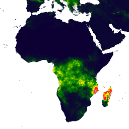
ข้อมูลปริมาณน้ำฝนแบบกึ่งทั่วโลกที่มีมานานกว่า 30 ปีคือข้อมูลปริมาณน้ำฝนจากรังสีอินฟราเรดของศูนย์อันตรายจากสภาพอากาศพร้อมข้อมูลสถานี (CHIRPS) CHIRPS ผสานรวมภาพจากดาวเทียมความละเอียด 0.05° กับข้อมูลสถานีภาคพื้นดิน เพื่อสร้างอนุกรมเวลาของปริมาณน้ำฝนแบบกริดสำหรับการวิเคราะห์แนวโน้มและการตรวจสอบภัยแล้งตามฤดูกาล
ย่านความถี่
ย่านความถี่
ขนาดพิกเซล: 5,566 เมตร (ทุกแถบ)
| ชื่อ | หน่วย | ต่ำสุด | สูงสุด | ขนาดพิกเซล | คำอธิบาย |
|---|---|---|---|---|---|
precipitation |
มม./ว | 0* | 1444.34* | 5,566 เมตร | หยาดน้ำฟ้า |
ข้อกำหนดในการใช้งาน
ข้อกำหนดในการใช้งาน
ชุดข้อมูลนี้เป็นสาธารณสมบัติ ตามขอบเขตที่กฎหมายอนุญาต Pete Peterson ได้สละสิทธิ์ในลิขสิทธิ์และสิทธิที่เกี่ยวข้องหรือสิทธิข้างเคียงทั้งหมดของ ปริมาณน้ำฝนที่วัดได้จากสถานีตรวจวัดในย่านที่เกิดอันตรายจากสภาพอากาศ (CHIRPS)
การอ้างอิง
Funk, Chris, Pete Peterson, Martin Landsfeld, Diego Pedreros, James Verdin, Shraddhanand Shukla, Gregory Husak, James Rowland, Laura Harrison, Andrew Hoell และ Joel Michaelsen "ปริมาณน้ำฝนที่วัดด้วยรังสีอินฟราเรดจากอันตรายด้านสภาพอากาศ พร้อมสถานี - บันทึกด้านสิ่งแวดล้อมใหม่สำหรับการตรวจสอบเหตุการณ์สุดขั้ว" Scientific Data 2, 150066. doi:10.1038/sdata.2015.66 2015.
สำรวจด้วย Earth Engine
ตัวแก้ไขโค้ด (JavaScript)
var dataset = ee.ImageCollection('UCSB-CHG/CHIRPS/DAILY')
                  .filter(ee.Filter.date('2018-05-01', '2018-05-03'));
var precipitation = dataset.select('precipitation');
var precipitationVis = {
  min: 1,
  max: 17,
  palette: ['001137', '0aab1e', 'e7eb05', 'ff4a2d', 'e90000'],
};
Map.setCenter(17.93, 7.71, 2);
Map.addLayer(precipitation, precipitationVis, 'Precipitation');
import ee
import geemap.core as geemap
Colab (Python)
dataset = ee.ImageCollection('UCSB-CHG/CHIRPS/DAILY').filter(
    ee.Filter.date('2018-05-01', '2018-05-03')
)
precipitation = dataset.select('precipitation')
precipitation_vis = {
    'min': 1,
    'max': 17,
    'palette': ['001137', '0aab1e', 'e7eb05', 'ff4a2d', 'e90000'],
}

m = geemap.Map()
m.set_center(17.93, 7.71, 2)
m.add_layer(precipitation, precipitation_vis, 'Precipitation')
m