- ความพร้อมใช้งานของชุดข้อมูล
- 2016-01-01T00:00:00Z–2017-01-02T00:00:00Z
- ผู้ผลิตชุดข้อมูล
- สำนักงานสำมะโนประชากรสหรัฐอเมริกา
- แท็ก
คำอธิบาย
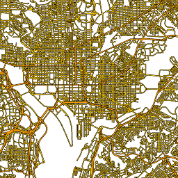
ชุดข้อมูล TIGER ของสำนักสำรวจประชากรสหรัฐอเมริกานี้มีส่วนถนนทั้งหมด จากการเผยแพร่ในปี 2016 ซึ่งมีฟีเจอร์เส้นแต่ละรายการมากกว่า 19 ล้านรายการ ที่ครอบคลุมสหรัฐอเมริกา เขตปกครองโคลัมเบีย เปอร์โตริโก และพื้นที่ที่เป็นเกาะ ฟีเจอร์แต่ละรายการแสดงถึงรูปเรขาคณิตของส่วนถนน (เส้นทางเชิงเส้นที่นำทางได้เส้นเดียวซึ่งเชื่อมต่อกับทางแยกอย่างน้อย 1 แห่ง)
ดูรายละเอียดทางเทคนิคทั้งหมดเกี่ยวกับผลิตภัณฑ์ TIGER 2016 ได้ที่เอกสารประกอบทางเทคนิคของ TIGER
สคีมาของตาราง
สคีมาของตาราง
| ชื่อ | ประเภท | คำอธิบาย |
|---|---|---|
| ชื่อเต็ม | STRING | ชื่อถนนที่มนุษย์อ่านได้ |
| linearid | STRING | ตัวระบุหลักที่ใช้เพื่ออ้างอิงถึงแถวนี้ในผลิตภัณฑ์ TIGER อื่นๆ |
| mtfcc | STRING | รหัสลำดับความสำคัญของถนน เช่น แสดงถึงถนนหลัก ถนนรอง ถนนท้องถิ่น เป็นต้น |
| rttyp | STRING | รหัสประเภทเส้นทาง |
ข้อกำหนดในการใช้งาน
ข้อกำหนดในการใช้งาน
สำนักสำรวจสำมะโนประชากรสหรัฐฯ มีข้อมูลสาธารณะบางส่วน ในรูปแบบที่เครื่องอ่านได้ผ่าน Application Programming Interface (API) เนื้อหา เอกสารประกอบ โค้ด และสื่อที่เกี่ยวข้องทั้งหมด ซึ่งพร้อมใช้งานผ่าน API จะอยู่ภายใต้ข้อกำหนดและ เงื่อนไขเหล่านี้
การอ้างอิง
ผู้ใช้ควรอ้างอิงสำนักสำรวจสำมะโนประชากรของสหรัฐอเมริกาสำหรับการสร้างรายงาน สิ่งพิมพ์ ชุดข้อมูลใหม่ ผลิตภัณฑ์ที่ได้มา หรือบริการที่ได้จากชุดข้อมูล
สำรวจด้วย Earth Engine
ตัวแก้ไขโค้ด (JavaScript)
var dataset = ee.FeatureCollection('TIGER/2016/Roads');
var roads = dataset.style({color: '#4285F4', width: 1});
Map.setCenter(-73.99172, 40.74101, 12);
Map.addLayer(roads, {}, 'TIGER/2016/Roads');
แสดงภาพเป็น FeatureView
FeatureView คือการแสดงFeatureCollectionแบบเร่งความเร็วที่ดูได้อย่างเดียว ดูรายละเอียดเพิ่มเติมได้ที่
เอกสารประกอบของ FeatureView
ตัวแก้ไขโค้ด (JavaScript)
var fvLayer = ui.Map.FeatureViewLayer('TIGER/2016/Roads_FeatureView');

var visParams = {
  color: '4285f4'
};

fvLayer.setVisParams(visParams);
fvLayer.setName('US census roads');

Map.setCenter(-73.99172, 40.74101, 14);
Map.add(fvLayer);