- Veri Kümesi Kullanılabilirliği
- 2012-02-01T00:00:00Z–2021-02-01T00:00:00Z
- Veri Kümesi Üreticisi
- TERN Landscapes / CSIRO Land and Water
- Etiketler
Açıklama
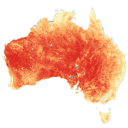
Bu veri kümesi, CMRSET algoritması kullanılarak Avustralya için doğru gerçek evapotranspirasyon (AET veya ETa) verileri sağlar. AET bandı ("ETa" olarak adlandırılır), o ay içinde bulutsuz tüm Landsat gözlemleri için CMRSET modelinden elde edilen ortalama günlük değeri içerir (AET Veri Kaynağı QA bitlerinde 3 değeriyle gösterilir). Landsat 7 ETM+ Taramalı Çizgi Düzeltici (SLC) 31 Mayıs 2003'te arızalandıktan sonra Landsat 7 ETM+ verileri yalnızca o ay için bulutsuz Landsat 5 TM veya Landsat 8 OLI verileri yoksa kullanılır. Bulutsuz Landsat yoksa pikseller Landsat-VIIRS karışık çıkışıyla doldurulur (AET Veri Kaynağı Kalite Kontrolü bitlerinde 2 değeriyle gösterilir). Bir ayda VIIRS yoksa eksik aylık AET değerleri doğrusal olarak enterpolasyon yapılır (AET veri kaynağı kalite güvencesi bitlerinde 1 değeriyle gösterilir). Bu, Avustralya'nın tamamını kapsayan ve bulut nedeniyle boşluk içermeyen aylık 30 milyon AET verisinin kullanıma hazır olduğu anlamına gelir.
Doğru AET bilgileri sulama, gıda güvenliği ve çevre yönetimi için önemlidir. Dünyanın birçok yerinde olduğu gibi Avustralya'da da su kaynakları sınırlıdır ve AET, su dengesinin en büyük tüketim bileşenidir. Avustralya'da mevcut suyun% 70'i mahsul ve otlak sulaması için kullanılmaktadır. Daha iyi izleme, bu sektörde su kullanım verimliliğinin artırılmasına yardımcı olacak ve su tasarrufu, çevresel akış olarak kullanılabilecektir. Ayrıca, yeraltı suyuna bağımlı ekosistemler (GDE) küçük bir alanı kaplar ancak "biyoçeşitlilik açısından önemli bölgelerdir". Su ihtiyaçlarını bilmek bu kritik alanların daha iyi yönetilmesini sağlar. AET, su toplama alanındaki su dengesini modellemek için de kullanılabilir. Su dengesi (kütle dengesi) hesaplamalarında kullanılıyorsa bu AET değerinin aydaki gün sayısıyla çarpılması gerekir.
Bu veri kümesini kullandığınızı geliştiricilere bildirmek, güncellemeler hakkında bilgi almak veya sorularınızı sormak için lütfen şu adreslerle iletişime geçin: tim.mcvicar@csiro.au, tom.vanniel@csiro.au, jamie.vleeshouwer@csiro.au .
Bantlar
Bantlar
Piksel boyutu: 30 metre (tüm bantlar)
| Ad | Birim | Piksel Boyutu | Açıklama | ||||||||||||||||||||||||||||||||||||||||||||||||||||||||||||||||||||||||||||||||||||||||||||||||
|---|---|---|---|---|---|---|---|---|---|---|---|---|---|---|---|---|---|---|---|---|---|---|---|---|---|---|---|---|---|---|---|---|---|---|---|---|---|---|---|---|---|---|---|---|---|---|---|---|---|---|---|---|---|---|---|---|---|---|---|---|---|---|---|---|---|---|---|---|---|---|---|---|---|---|---|---|---|---|---|---|---|---|---|---|---|---|---|---|---|---|---|---|---|---|---|---|---|---|---|
ETa |
mm/d | 30 metre | Ortalama günlük evapotranspirasyon (mm/gün) |
||||||||||||||||||||||||||||||||||||||||||||||||||||||||||||||||||||||||||||||||||||||||||||||||
pixel_qa |
30 metre | Pixel QA özellikleri |
|||||||||||||||||||||||||||||||||||||||||||||||||||||||||||||||||||||||||||||||||||||||||||||||||
Kullanım Şartları
Kullanım Şartları
Alıntılar
Juan P. Guerschman, Tim R. McVicar, Jamie Vleeshower, Thomas G. Van Niel, Jorge L. Peña-Arancibia, Yun Chen. Estimating actual evapotranspiration at field-to-continent scales by calibrating the CMRSET algorithm with MODIS, VIIRS, Landsat and Sentinel-2 data, Journal of Hydrology, Volume 605, 2022, 127318, doi:10.1016/j.jhydrol.2021.127318.
DOI'lar
Earth Engine ile Keşif
Kod Düzenleyici (JavaScript)
var dataset = ee.ImageCollection('TERN/AET/CMRSET_LANDSAT_V2_1');

var visualization = {
  bands: ['ETa'],
  min: 1,
  max: 7,
  palette: ['d7191c', 'fdae61', 'ffffbf', 'abd9e9', '2c7bb6']
};

Map.setCenter(132, -27, 4);

Map.addLayer(
    dataset, visualization, 'Average daily evapotranspiration (mm/day)');