Page Summary
-
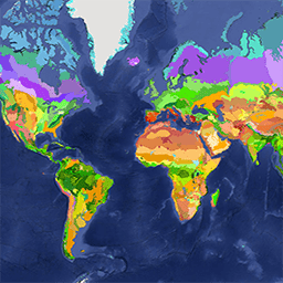
The RESOLVE Ecoregions dataset from 2017 maps 846 terrestrial ecoregions globally.
-
Ecoregions are defined as ecosystems of regional extent that represent distinct assemblages of biodiversity.
-
The dataset groups ecoregions into 14 biomes and 8 realms, with detailed analysis on habitat remaining and protected areas.
-
Each ecoregion is assigned one of four "Nature Needs Half" (NNH) categories based on habitat protection status.
-
This updated dataset is used to track progress towards the goal of protecting half of Earth's land.
- Dataset Availability
- 2017-04-05T00:00:00Z–2017-04-05T00:00:00Z
- Dataset Producer
- RESOLVE Biodiversity and Wildlife Solutions
- Tags
Description
The RESOLVE Ecoregions dataset, updated in 2017, offers a depiction of the 846 terrestrial ecoregions that represent our living planet. View the stylized map at https://ecoregions2017.appspot.com/ or in Earth Engine.
Ecoregions, in the simplest definition, are ecosystems of regional extent. Specifically, ecoregions represent distinct assemblages of biodiversity-all taxa, not just vegetation-whose boundaries include the space required to sustain ecological processes. Ecoregions provide a useful basemap for conservation planning in particular because they draw on natural, rather than political, boundaries, define distinct biogeographic assemblages and ecological habitats within biomes, and assist in representation of Earth's biodiversity.
This dataset is based on recent advances in biogeography - the science concerning the distribution of plants and animals. The original ecoregions dataset has been widely used since its introduction in 2001, underpinning the most recent analyses of the effects of global climate change on nature by ecologists to the distribution of the world's beetles to modern conservation planning.
The 846 terrestrial ecoregions are grouped into 14 biomes and 8 realms. Six of these biomes are forest biomes and remaining eight are non-forest biomes. For the forest biomes, the geographic boundaries of the ecoregions (Dinerstein et al., 2017) and protected areas (UNEP-WCMC 2016) were intersected with the Global Forest Change data (Hansen et al. 2013) for the years 2000 to 2015, to calculate percent of habitat in protected areas and percent of remaining habitat outside protected areas. Likewise, the boundaries of the non-forest ecoregions and protected areas (UNEP-WCMC 2016) were intersected with Anthropogenic Biomes data (Anthromes v2) for the year 2000 (Ellis et al., 2010) to identify remaining habitats inside and outside the protected areas. Each ecoregion has a unique ID, area (sq. degrees), and NNH (Nature Needs Half) categories 1-4. NNH categories are based on percent of habitat in protected areas and percent of remaining habitat outside protected areas.
- Half Protected: More than 50% of the total ecoregion area is already protected.
- Nature Could Reach Half: Less than 50% of the total ecoregion area is protected but the amount of remaining unprotected natural habitat could bring protection to over 50% if new conservation areas are added to the system.
- Nature Could Recover: The amount of protected and unprotected natural habitat remaining is less than 50% but more than 20%. Ecoregions in this category would require restoration to reach Half Protected.
- Nature Imperiled: The amount of protected and unprotected natural habitat remaining is less than or equal to 20%. Achieving half protected is not possible in the short term and efforts should focus on conserving remaining, native habitat fragments.
The updated Ecoregions 2017 is the most-up-to-date (as of February 2018) dataset on remaining habitat in each terrestrial ecoregion. It was released to chart progress towards achieving the visionary goal of Nature Needs Half, to protect half of all the land on Earth to save a living terrestrial biosphere.
Note - a number of ecoregions are very complex polygons with over a million vertices, such as Rock & Ice. These ecoregions were split when necessary, with attributes like Eco_ID being preserved. If you'd like to see all ecoregions that have been split, please run this script.
Table Schema
Table Schema
| Name | Type | Description |
|---|---|---|
| BIOME_NAME | STRING | Biome name |
| BIOME_NUM | DOUBLE | Biome number |
| COLOR | STRING | Color |
| COLOR_BIO | STRING | Biome color |
| COLOR_NNH | STRING | NNH color |
| ECO_ID | DOUBLE | Ecoregion unique ID |
| ECO_NAME | STRING | Ecoregion name |
| LICENSE | STRING | CC-BY 4.0 |
| NNH | DOUBLE | NNH category (1-4) based on percent of habitat in protected areas and percent of remaining habitat outside protected areas |
| NNH_NAME | STRING | Half Protected, Nature Could Reach Half, Nature Could Recover, or Nature Imperiled |
| OBJECTID | DOUBLE | Object id |
| REALM | STRING | Realm name |
| SHAPE_AREA | DOUBLE | Area of ecoregion polygon in square degrees |
| SHAPE_LENG | DOUBLE | Length of ecoregion polygon in degrees |
Terms of Use
Terms of Use
Citations
Explore with Earth Engine
Code Editor (JavaScript)
var ecoRegions = ee.FeatureCollection('RESOLVE/ECOREGIONS/2017');

// patch updated colors
var colorUpdates = [
{ECO_ID: 204, COLOR: '#B3493B'},
{ECO_ID: 245, COLOR: '#267400'},
{ECO_ID: 259, COLOR: '#004600'},
{ECO_ID: 286, COLOR: '#82F178'},
{ECO_ID: 316, COLOR: '#E600AA'},
{ECO_ID: 453, COLOR: '#5AA500'},
{ECO_ID: 317, COLOR: '#FDA87F'},
{ECO_ID: 763, COLOR: '#A93800'},
];

// loop over all other features and create a new style property for styling
// later on
var ecoRegions = ecoRegions.map(function(f) {
  var color = f.get('COLOR');
  return f.set({style: {color: color, width: 0}});
});

// make styled features for the regions we need to update colors for,
// then strip them from the main asset and merge in the new feature
for (var i=0; i < colorUpdates.length; i++) {
  colorUpdates[i].layer = ecoRegions
      .filterMetadata('ECO_ID','equals',colorUpdates[i].ECO_ID)
      .map(function(f) {
        return f.set({style: {color: colorUpdates[i].COLOR, width: 0}});
      });

  ecoRegions = ecoRegions
      .filterMetadata('ECO_ID','not_equals',colorUpdates[i].ECO_ID)
      .merge(colorUpdates[i].layer);
}

// use style property to color shapes
var imageRGB = ecoRegions.style({styleProperty: 'style'});

Map.setCenter(16, 49, 4);
Map.addLayer(imageRGB, {}, 'RESOLVE/ECOREGIONS/2017');
import ee
import geemap.core as geemap
Colab (Python)
eco_regions = ee.FeatureCollection('RESOLVE/ECOREGIONS/2017')

# patch updated colors
color_updates = [
    {'ECO_ID': 204, 'COLOR': '#B3493B'},
    {'ECO_ID': 245, 'COLOR': '#267400'},
    {'ECO_ID': 259, 'COLOR': '#004600'},
    {'ECO_ID': 286, 'COLOR': '#82F178'},
    {'ECO_ID': 316, 'COLOR': '#E600AA'},
    {'ECO_ID': 453, 'COLOR': '#5AA500'},
    {'ECO_ID': 317, 'COLOR': '#FDA87F'},
    {'ECO_ID': 763, 'COLOR': '#A93800'},
]

# loop over all other features and create a new style property for styling
# later on
eco_regions = eco_regions.map(
    lambda f: f.set({'style': {'color': f.get('COLOR'), 'width': 0}})
)

# make styled features for the regions we need to update colors for,
# then strip them from the main asset and merge in the new feature
for i in range(len(color_updates)):
  color_updates[i]['layer'] = eco_regions.filterMetadata(
      'ECO_ID', 'equals', color_updates[i]['ECO_ID']
  ).map(
      lambda f: f.set(
          {'style': {'color': color_updates[i]['COLOR'], 'width': 0}}
      )
  )

  eco_regions = eco_regions.filterMetadata(
      'ECO_ID', 'not_equals', color_updates[i]['ECO_ID']
  ).merge(color_updates[i]['layer'])

# use style property to color shapes
image_rgb = eco_regions.style(styleProperty='style')

m = geemap.Map()
m.set_center(16, 49, 4)
m.add_layer(image_rgb, {}, 'RESOLVE/ECOREGIONS/2017')
m
Visualize as a FeatureView
A FeatureView is a view-only, accelerated representation of a
FeatureCollection. For more details, visit the
FeatureView documentation.
Code Editor (JavaScript)
var fvLayer = ui.Map.FeatureViewLayer('RESOLVE/ECOREGIONS/2017_FeatureView');

var visParams = {
  opacity: 1,
  polygonFillColor: {
    property: 'NNH_NAME',
    categories: [
      ['Half Protected', 'blue'],
      ['Nature Could Reach Half Protected', 'green'],
      ['Nature Could Recover', 'yellow'],
      ['Nature Imperiled', 'orange']
    ],
    defaultValue: 'lightgrey'
  }
};

fvLayer.setVisParams(visParams);
fvLayer.setName('Ecoregions (Nature Needs Half category)');

Map.setCenter(16, 49, 4);
Map.add(fvLayer);
import ee
import geemap.core as geemap
Colab (Python)
eco_regions = ee.FeatureCollection('RESOLVE/ECOREGIONS/2017')

# patch updated colors
color_updates = [
    {'ECO_ID': 204, 'COLOR': '#B3493B'},
    {'ECO_ID': 245, 'COLOR': '#267400'},
    {'ECO_ID': 259, 'COLOR': '#004600'},
    {'ECO_ID': 286, 'COLOR': '#82F178'},
    {'ECO_ID': 316, 'COLOR': '#E600AA'},
    {'ECO_ID': 453, 'COLOR': '#5AA500'},
    {'ECO_ID': 317, 'COLOR': '#FDA87F'},
    {'ECO_ID': 763, 'COLOR': '#A93800'},
]

# loop over all other features and create a new style property for styling
# later on
eco_regions = eco_regions.map(
    lambda f: f.set({'style': {'color': f.get('COLOR'), 'width': 0}})
)

# make styled features for the regions we need to update colors for,
# then strip them from the main asset and merge in the new feature
for i in range(len(color_updates)):
  color_updates[i]['layer'] = eco_regions.filterMetadata(
      'ECO_ID', 'equals', color_updates[i]['ECO_ID']
  ).map(
      lambda f: f.set(
          {'style': {'color': color_updates[i]['COLOR'], 'width': 0}}
      )
  )

  eco_regions = eco_regions.filterMetadata(
      'ECO_ID', 'not_equals', color_updates[i]['ECO_ID']
  ).merge(color_updates[i]['layer'])

# use style property to color shapes
image_rgb = eco_regions.style(styleProperty='style')

m = geemap.Map()
m.set_center(16, 49, 4)
m.add_layer(image_rgb, {}, 'RESOLVE/ECOREGIONS/2017')
m