- Disponibilidade do conjunto de dados
- 2019-01-01T00:00:00Z–2020-01-01T00:00:00Z
- Produtor de conjunto de dados
- Malaria Atlas Project
- Tags
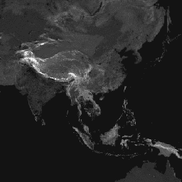
Descrição
Essa superfície de fricção global enumera a velocidade de deslocamento terrestre para todos os pixels de terra entre 85 graus norte e 60 graus sul para um ano nominal de 2019. Ela também inclui a velocidade de deslocamento "somente a pé", usando apenas meios de transporte não motorizados. Este mapa foi produzido em colaboração entre a MAP (Universidade de Oxford), o Telethon Kids Institute (Perth, Austrália), o Google e a Universidade de Twente, na Holanda. Este projeto se baseia em trabalhos anteriores publicados por Weiss et al 2018 (doi:10.1038/nature25181). Weiss et al. (2018) usaram conjuntos de dados de vias (que compreendem o primeiro uso em escala global do Open Street Map e dos conjuntos de dados de vias do Google), ferrovias, rios, lagos, oceanos, condições topográficas (inclinação e elevação), tipos de cobertura do solo e fronteiras nacionais. Cada um desses conjuntos de dados recebeu uma ou mais velocidades de deslocamento em termos de tempo para atravessar cada pixel desse tipo. Em seguida, os conjuntos de dados foram combinados para produzir uma "superfície de fricção", um mapa em que cada pixel recebe uma velocidade geral nominal de deslocamento com base nos tipos que ocorrem nele. Para o projeto atual, foi criada uma superfície de atrito atualizada para incorporar melhorias recentes nos dados de vias do OSM. As diferenças entre essa superfície de atrito e a versão de 2015 (Weiss et al., 2018) não indicam necessariamente mudanças na infraestrutura (por exemplo, construção de novas estradas). Essas discrepâncias têm muito mais chances de estar associadas à melhoria da qualidade de dados, principalmente atualizações feitas na cobertura de vias do OSM. Por isso, as comparações entre as superfícies de fricção e os mapas de tempo de viagem resultantes precisam ser feitas com cuidado e geralmente não devem ser interpretadas como representando mudanças no acesso ao longo do tempo. Esse mapa representa a velocidade de viagem desse processo de alocação, expressa em unidades de minutos necessários para viajar um metro. Ele forma o conjunto de dados subjacente por trás do mapa global de acessibilidade de assistência médica descrito no artigo referenciado.
Os créditos do conjunto de dados de origem são descritos no artigo acompanhante.
Bandas
Bandas
Tamanho do pixel: 927,67 metros (todas as bandas)
| Nome | Unidades | Mín. | Máx. | Tamanho do pixel | Descrição |
|---|---|---|---|---|---|
friction |
minutos/metro | 0,000429 | 87,3075 | 927,67 metros | Velocidade de viagem terrestre. |
friction_walking_only |
minutos/metro | 0.012 | 87,3075 | 927,67 metros | Velocidade de deslocamento terrestre usando transporte não motorizado. |
Termos de Uso
Termos de Uso
Este trabalho está licenciado sob uma Licença Creative Commons Atribuição 4.0 Internacional.
Citações
D.J. Weiss, A. Nelson, C.A. Vargas-Ruiz, K. Gligorić, S. Bavadekar, E. Gabrilovich, A. Bertozzi-Villa, J. Rozier, H.S. Gibson, T. Shekel, C. Kamath, A. Lieber, K. Schulman, Y. Shao, V. Qarkaxhija, A.K. Nandi, S.H. Keddie, S. Rumisha, E. Cameron, K.E. Battle, S. Bhatt, P.W. Gething. Mapas globais do tempo de viagem até as instituições de saúde. Nature Medicine (2020).
Explore com o Earth Engine
Editor de código (JavaScript)
var dataset = ee.Image('Oxford/MAP/friction_surface_2019');
var landBasedTravelSpeed = dataset.select('friction');
var visParams = {
  min: 0.0022,
  max: 0.04,
  palette: [
    '313695', '4575b4', '74add1', 'abd9e9', 'e0f3f8', 'ffffbf', 'fee090',
    'fdae61', 'f46d43', 'd73027', 'a50026'
  ],
};
Map.setCenter(43.55, 36.98, 4);
Map.addLayer(landBasedTravelSpeed, visParams, 'Land-based travel speed');