- ความพร้อมใช้งานของชุดข้อมูล
- 1950-01-01T00:00:00Z–2018-01-01T00:00:00Z
- ผู้ผลิตชุดข้อมูล
- EnvirometriX Ltd
- แท็ก
คำอธิบาย
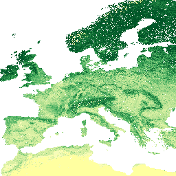
ปริมาณคาร์บอนอินทรีย์ในดินในหน่วย x 5 กรัม / กก. ที่ความลึกมาตรฐาน 6 ระดับ (0, 10, 30, 60, 100 และ 200 ซม.) ที่ความละเอียด 250 ม.
คาดการณ์จากจุดดินที่รวบรวมจากทั่วโลก ขั้นตอนการประมวลผลมีคำอธิบายโดยละเอียดที่นี่ ไม่รวมทวีปแอนตาร์กติกา
หากต้องการเข้าถึงและแสดงภาพแผนที่ภายนอก Earth Engine ให้ใช้หน้านี้
หากพบข้อบกพร่อง อาร์ติแฟกต์ หรือความไม่สอดคล้องกันในแผนที่ LandGIS หรือหากมีคำถาม โปรดใช้ช่องทางต่อไปนี้
ย่านความถี่
ย่านความถี่
ขนาดพิกเซล: 250 เมตร (ทุกแถบ)
| ชื่อ | หน่วย | ต่ำสุด | สูงสุด | สเกล | ขนาดพิกเซล | คำอธิบาย |
|---|---|---|---|---|---|---|
b0 |
ก./กก. | 0* | 120* | 5 | 250 เมตร | ปริมาณคาร์บอนอินทรีย์ในดินที่ความลึก 0 ซม. |
b10 |
ก./กก. | 0* | 120* | 5 | 250 เมตร | ปริมาณคาร์บอนอินทรีย์ในดินที่ความลึก 10 ซม. |
b30 |
ก./กก. | 0* | 120* | 5 | 250 เมตร | ปริมาณคาร์บอนอินทรีย์ในดินที่ความลึก 30 ซม. |
b60 |
ก./กก. | 0* | 120* | 5 | 250 เมตร | ปริมาณคาร์บอนอินทรีย์ในดินที่ความลึก 60 ซม. |
b100 |
ก./กก. | 0* | 120* | 5 | 250 เมตร | ปริมาณคาร์บอนอินทรีย์ในดินที่ความลึก 100 ซม. |
b200 |
ก./กก. | 0* | 120* | 5 | 250 เมตร | ปริมาณคาร์บอนอินทรีย์ในดินที่ความลึก 200 ซม. |
ข้อกำหนดในการใช้งาน
ข้อกำหนดในการใช้งาน
การอ้างอิง
Tomislav Hengl และ Ichsani Wheeler (2018) ปริมาณคาร์บอนอินทรีย์ในดินในหน่วย x 5 กรัม / กก. ที่ความลึกมาตรฐาน 6 ระดับ (0, 10, 30, 60, 100 และ 200 ซม.) ที่ความละเอียด 250 ม. (เวอร์ชัน v02) [ชุดข้อมูล] Zenodo 10.5281/zenodo.1475457
DOI
สำรวจด้วย Earth Engine
ตัวแก้ไขโค้ด (JavaScript)
var dataset = ee.Image('OpenLandMap/SOL/SOL_ORGANIC-CARBON_USDA-6A1C_M/v02');

var visualization = {
  bands: ['b0'],
  min: 0.0,
  max: 120.0,
  palette: [
    'ffffa0','f7fcb9','d9f0a3','addd8e','78c679','41ab5d',
    '238443','005b29','004b29','012b13','00120b',
  ]
};

Map.centerObject(dataset);

Map.addLayer(dataset, visualization, 'Soil organic carbon content in x 5 g / kg');