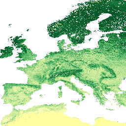
250m 해상도에서 6개의 표준 깊이(0, 10, 30, 60, 100, 200cm)의 토양 유기 탄소 함량(x 5g / kg)입니다. 전 세계 토양 지점의 컴파일에서 예측되었습니다. 처리 단계는 여기에 자세히 설명되어 있습니다. 남극은 포함되지 않습니다. 지도에 액세스하고 시각화하려면 다음 단계를 따르세요.
[[["이해하기 쉬움","easyToUnderstand","thumb-up"],["문제가 해결됨","solvedMyProblem","thumb-up"],["기타","otherUp","thumb-up"]],[["필요한 정보가 없음","missingTheInformationINeed","thumb-down"],["너무 복잡함/단계 수가 너무 많음","tooComplicatedTooManySteps","thumb-down"],["오래됨","outOfDate","thumb-down"],["번역 문제","translationIssue","thumb-down"],["샘플/코드 문제","samplesCodeIssue","thumb-down"],["기타","otherDown","thumb-down"]],[],[],["The dataset provides soil organic carbon content data in g/kg at six depths (0, 10, 30, 60, 100, and 200 cm) with a 250m resolution from 1950 to 2018, excluding Antarctica. EnvirometriX Ltd. is the provider. Data is derived from global soil point compilations and is accessible via Google Earth Engine, which includes a visualization tool and code editor. Data can be accessed with the `ee.Image` function and it has a CC-BY-SA-4.0 license.\n"]]