- Доступность набора данных
- 1950-01-01T00:00:00Z–2018-01-01T00:00:00Z
- Производитель наборов данных
- EnvirometriX Ltd
- Теги
- объем
Описание
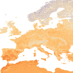
Плотность грунта (мелкозернистой почвы) 10 х кг/ м³ на 6 стандартных глубинах (0, 10, 30, 60, 100 и 200 см) с разрешением 250 м.
Этапы обработки подробно описаны здесь . Антарктида не включена.
Для доступа к картам и их визуализации вне Earth Engine используйте эту страницу .
Если вы обнаружили ошибку, артефакт или несоответствие на картах LandGIS, или если у вас есть вопрос, пожалуйста, используйте следующие каналы связи:
Группы
Группы
Размер пикселя: 250 метров (все диапазоны)
| Имя | Единицы | Мин | Макс | Шкала | Размер пикселя | Описание |
|---|---|---|---|---|---|---|
b0 | кг/м³ | 5* | 185* | 10 | 250 метров | Плотность грунта на глубине 0 см |
b10 | кг/м³ | 5* | 185* | 10 | 250 метров | Плотность грунта на глубине 10 см |
b30 | кг/м³ | 5* | 185* | 10 | 250 метров | Плотность грунта на глубине 30 см |
b60 | кг/м³ | 5* | 185* | 10 | 250 метров | Плотность грунта на глубине 60 см |
b100 | кг/м³ | 5* | 185* | 10 | 250 метров | Плотность грунта на глубине 100 см |
b200 | кг/м³ | 5* | 185* | 10 | 250 метров | Плотность грунта на глубине 200 см |
Условия эксплуатации
Условия эксплуатации
Цитаты
Томислав Хенгл. (2018). Плотность грунта (мелкозернистая почва) 10 x кг/м³ на 6 стандартных глубинах (0, 10, 30, 60, 100 и 200 см) с разрешением 250 м (версия v02) [Набор данных]. Zenodo. 10.5281/zenodo.1475970
DOI
Исследуйте мир с помощью Earth Engine.
Редактор кода (JavaScript)
var dataset = ee.Image('OpenLandMap/SOL/SOL_BULKDENS-FINEEARTH_USDA-4A1H_M/v02');

var visualization = {
  bands: ['b0'],
  min: 5.0,
  max: 185.0,
  palette: ['5e3c99', 'b2abd2', 'f7e0b2', 'fdb863', 'e63b01']
};

Map.centerObject(dataset);

Map.addLayer(dataset, visualization, 'Soil bulk density in x 10 kg / m3');