Page Summary
-
This dataset provides soil bulk density at six standard depths with a 250m resolution.
-
The dataset covers the period from 1950 to 2018 but excludes Antarctica.
-
Data is provided in units of 10 x kg/m^3^, with a scale factor of 10 to convert to kg/m^3.
-
The data is available under the CC-BY-SA-4.0 license.
-
The dataset was published by EnvirometriX Ltd and can be cited using the provided DOI.
- Dataset Availability
- 1950-01-01T00:00:00Z–2018-01-01T00:00:00Z
- Dataset Producer
- EnvirometriX Ltd
- Tags
Description
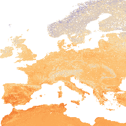
Soil bulk density (fine earth) 10 x kg / m3 at 6 standard depths (0, 10, 30, 60, 100 and 200 cm) at 250 m resolution.
Processing steps are described in detail here. Antarctica is not included.
To access and visualize maps outside of Earth Engine, use this page.
If you discover a bug, artifact or inconsistency in the LandGIS maps or if you have a question please use the following channels:
Bands
Bands
Pixel size: 250 meters (all bands)
| Name | Units | Min | Max | Scale | Pixel Size | Description |
|---|---|---|---|---|---|---|
b0 |
kg/m^3 | 5* | 185* | 10 | 250 meters | Soil bulk density at 0 cm depth |
b10 |
kg/m^3 | 5* | 185* | 10 | 250 meters | Soil bulk density at 10 cm depth |
b30 |
kg/m^3 | 5* | 185* | 10 | 250 meters | Soil bulk density at 30 cm depth |
b60 |
kg/m^3 | 5* | 185* | 10 | 250 meters | Soil bulk density at 60 cm depth |
b100 |
kg/m^3 | 5* | 185* | 10 | 250 meters | Soil bulk density at 100 cm depth |
b200 |
kg/m^3 | 5* | 185* | 10 | 250 meters | Soil bulk density at 200 cm depth |
Terms of Use
Terms of Use
Citations
Tomislav Hengl. (2018). Soil bulk density (fine earth) 10 x kg / m-cubic at 6 standard depths (0, 10, 30, 60, 100 and 200 cm) at 250 m resolution (Version v02) [Data set]. Zenodo. 10.5281/zenodo.1475970
DOIs
Explore with Earth Engine
Code Editor (JavaScript)
var dataset = ee.Image('OpenLandMap/SOL/SOL_BULKDENS-FINEEARTH_USDA-4A1H_M/v02');

var visualization = {
  bands: ['b0'],
  min: 5.0,
  max: 185.0,
  palette: ['5e3c99', 'b2abd2', 'f7e0b2', 'fdb863', 'e63b01']
};

Map.centerObject(dataset);

Map.addLayer(dataset, visualization, 'Soil bulk density in x 10 kg / m3');