- Dataset Availability
- 2014-04-03T00:00:00Z–2014-04-04T00:00:00Z
- Dataset Producer
- NASA JPL
- Tags
Description
This product contains static radar geometry layers associated with the OPERA Radiometric Terrain Corrected SAR Backscatter from Sentinel-1 dataset.
Due to the S1 mission’s narrow orbital tube, radar-geometry layers such as incidence angle, local incidence angle, number of looks, and RTC Area Normalization Factor (ANF) vary slightly over time for each position on the ground, and therefore are considered static. These static layers are provided separately from the OPERA RTC-S1 product, as they are produced only once or a limited number of times, to account for changes in the DEM, in the S1 orbit, or in the static-layers generation algorithm.
Bands
Bands
Pixel size: 30 meters (all bands)
| Name | Units | Pixel Size | Description |
|---|---|---|---|
local_incidence_angle |
deg | 30 meters | Angle between LOS vector and terrain normal vector at the target provided in the same geographic grid as the geocoded imagery. |
incidence_angle |
deg | 30 meters | Angle between LOS vector and the ellipsoid normal at the target provided in the same geographic grid as the geocoded imagery. |
number_of_looks |
30 meters | The number of radar samples used to compute each RTC-S1 imagery pixel, provided in the same geographic grid as the RTC-S1 product imagery. |
|
rtc_anf_gamma0_to_beta0 |
30 meters | The factors to normalize the gamma0 backscatter to beta0, provided in the same grid as the corresponding RTC-S1 imagery. |
|
rtc_anf_gamma0_to_sigma0 |
30 meters | The factors to normalize the gamma0 backscatter to sigma0, provided in the same grid as the associated RTC-S1 imagery. |
|
mask |
30 meters | Mask layer containing valid/invalid, layover, and shadow classification computed using the RTC-S1 burst orbit, provided over the same geographic grid as the associated geocoded imagery. |
mask Class Table
| Value | Color | Description |
|---|---|---|
| 0 | #000000 | Valid sample not affected by layover or shadow |
| 1 | #FF0000 | Valid sample affected by shadow |
| 2 | #00FF00 | Valid sample affected by layover |
| 3 | #FFFF00 | Valid sample affected by layover and shadow |
| 255 | #FFFFFF | Invalid sample |
Image Properties
Image Properties
| Name | Type | Description |
|---|---|---|
| ABSOLUTE_ORBIT_NUMBER | DOUBLE | Absolute orbit number |
| ACQUISITION_MODE | STRING | Acquisition mode |
| BURST_ID | STRING | Burst identification string |
| INPUT_L1_SLC_GRANULES | STRING_LIST | List of input L1 SLC granules |
| INPUT_ORBIT_FILES | STRING_LIST | List of input orbit files |
| INSTRUMENT_NAME | STRING | Name of the instrument used to collect the remote sensing data provided in this product |
| LOOK_DIRECTION | STRING | Look direction |
| ORBIT_PASS_DIRECTION | STRING | Orbit pass direction |
| PROCESSING_DATETIME | STRING | Product generation time in UTC. Format: YYYY-MM-DDTHH:MM:SSZ |
| PROCESSING_TYPE | STRING | Processing type. One of: "NOMINAL", "URGENT", "CUSTOM", or "UNDEFINED" |
| SUB_SWATH_ID | STRING | Sub-swath identifier |
| TRACK_NUMBER | DOUBLE | Track number |
Terms of Use
Terms of Use
This dataset is openly shared, without restriction, in accordance with the EOSDIS Data Use and Citation Guidance
Citations
NASA/JPL/OPERA. (2023). OPERA Radiometric Terrain Corrected SAR Backscatter from Sentinel-1 Static Layers validated product (Version 1) [Data set]. NASA Alaska Satellite Facility Distributed Active Archive Center. doi:10.5067/SNWG/OPERA_L2_RTC-S1-STATIC_V1
DOIs
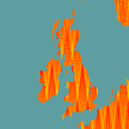
Explore with Earth Engine
Code Editor (JavaScript)
var geometry = ee.Geometry.BBox(-18, 49, 8, 60);
var waterLandMask =
    ee.Image('NOAA/NGDC/ETOPO1').select('bedrock').gte(0.0).clip(geometry);

var rtc_s1_static = ee.ImageCollection('OPERA/RTC/L2_V1/S1_STATIC')
                        .filterBounds(geometry)
                        .mean()
                        .mask(waterLandMask);

Map.centerObject(geometry);
Map.addLayer(
    rtc_s1_static.select('number_of_looks'),
    {min: 15, max: 19, palette: ['yellow', 'red']}, 'Number of Looks');