Page Summary
-
This dataset contains daily measurements of nocturnal visible and near-infrared light from the VIIRS sensor on the Suomi National Polar-orbiting Partnership satellite.
-
The VNP46A2 dataset provides daily moonlight- and atmosphere-corrected Nighttime Lights (NTL) using the Bidirectional Reflectance Distribution Function (BRDF).
-
This dataset has been superseded by NASA/VIIRS/002/VNP46A2.
- Dataset Availability
- 2012-01-19T00:00:00Z–2024-12-26T00:00:00Z
- Dataset Producer
- NASA LAADS DAAC
- Cadence
- 1 Day
- Tags
Description
The Suomi National Polar-orbiting Partnership (SNPP) Visible Infrared Imaging Radiometer Suite (VIIRS) supports a Day-Night Band (DNB) sensor that provides global daily measurements of nocturnal visible and near-infrared (NIR) light that are suitable for Earth system science and applications. The VIIRS DNB's ultra-sensitivity in lowlight conditions enables us to generate a new set of science-quality nighttime products that manifest substantial improvements in sensor resolution and calibration when compared to the previous era of Defense Meteorological Satellite Program/Operational Linescan System's (DMSP/OLS) nighttime lights image products.
VNP46A2 dataset is a daily moonlight- and atmosphere-corrected Nighttime Lights (NTL) product using the Bidirectional Reflectance Distribution Function (BRDF).
Documentation:
Bands
Bands
Pixel size: 500 meters (all bands)
| Name | Min | Max | Pixel Size | Description | |||||||||||||||||||||||||||||||||||||||||||||||||||||||||||||||||||||||||||||||||||||||||||||||
|---|---|---|---|---|---|---|---|---|---|---|---|---|---|---|---|---|---|---|---|---|---|---|---|---|---|---|---|---|---|---|---|---|---|---|---|---|---|---|---|---|---|---|---|---|---|---|---|---|---|---|---|---|---|---|---|---|---|---|---|---|---|---|---|---|---|---|---|---|---|---|---|---|---|---|---|---|---|---|---|---|---|---|---|---|---|---|---|---|---|---|---|---|---|---|---|---|---|---|---|
DNB_BRDF_Corrected_NTL |
0 | 6553.4 | 500 meters | BRDF corrected DNB NTL |
|||||||||||||||||||||||||||||||||||||||||||||||||||||||||||||||||||||||||||||||||||||||||||||||
Gap_Filled_DNB_BRDF_Corrected_NTL |
0 | 6553.4 | 500 meters | Gap Filled BRDF corrected DNB NTL |
|||||||||||||||||||||||||||||||||||||||||||||||||||||||||||||||||||||||||||||||||||||||||||||||
DNB_Lunar_Irradiance |
0 | 6553.4 | 500 meters | DNB Lunar Irradiance |
|||||||||||||||||||||||||||||||||||||||||||||||||||||||||||||||||||||||||||||||||||||||||||||||
Latest_High_Quality_Retrieval |
500 meters | Latest high quality BRDF corrected DNB radiance retrieval |
|||||||||||||||||||||||||||||||||||||||||||||||||||||||||||||||||||||||||||||||||||||||||||||||||
Mandatory_Quality_Flag |
0 | 3 | 500 meters | Mandatory quality flag |
|||||||||||||||||||||||||||||||||||||||||||||||||||||||||||||||||||||||||||||||||||||||||||||||
Snow_Flag |
0 | 1 | 500 meters | Flag for snow cover |
|||||||||||||||||||||||||||||||||||||||||||||||||||||||||||||||||||||||||||||||||||||||||||||||
QF_Cloud_Mask |
500 meters | Quality flag for cloud mask |
|||||||||||||||||||||||||||||||||||||||||||||||||||||||||||||||||||||||||||||||||||||||||||||||||
Mandatory_Quality_Flag Class Table
| Value | Color | Description |
|---|---|---|
| 0 | None | High-quality, Persistent nighttime lights |
| 1 | None | High-quality, Ephemeral nighttime Lights |
| 2 | None | Poor-quality, Outlier, potential cloud contamination, or other issues |
| 255 | None | No retrieval, Fill value (masked out on ingestion) |
Snow_Flag Class Table
| Value | Color | Description |
|---|---|---|
| 0 | None | No Snow/Ice |
| 1 | None | Snow/Ice |
Terms of Use
Terms of Use
LP DAAC NASA data are freely accessible; however, when an author publishes these data or works based on the data, it is requested that the author cite the datasets within the text of the publication and include a reference to them in the reference list.
Citations
Please visit LP DAAC 'Citing Our Data' page
DOIs
Explore with Earth Engine
Code Editor (JavaScript)
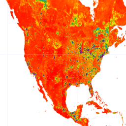
var dataset = ee.ImageCollection('NOAA/VIIRS/001/VNP46A2').filter(
  ee.Filter.date('2013-01-01', '2013-07-01'));

// Bidirectional Reflectance Distribution Function (BRDF)
var brdf = dataset.select('DNB_BRDF_Corrected_NTL');
var brdfVis = {
  min: 0,
  max: 100,
  palette: ['black', 'purple', 'cyan', 'green', 'yellow', 'red', 'white'],
};

Map.setCenter(-79.4, 43.1, 8);
// Day/Night Band (DNB)
// NightTime Light (NTL)
Map.addLayer(brdf, brdfVis, 'DNB_BRDF_Corrected_NTL');