Page Summary
-
The VNP43IA2 product provides daily BRDF and Albedo quality at 500m resolution using 16 days of VIIRS data.
-
It includes information on band quality, days of valid observation for VIIRS imagery bands, land/water type, and snow presence.
-
This dataset is available from January 17, 2012, to June 9, 2024, and is provided by the NASA LP DAAC at the USGS EROS Center.
-
The VNP43 products are designed to continue NASA's MODIS BRDF/Albedo data suite.
-
LP DAAC NASA data is freely accessible, and proper citation is requested when used in publications.
- Dataset Availability
- 2012-01-17T00:00:00Z–2024-06-09T00:00:00Z
- Dataset Producer
- NASA LP DAAC at the USGS EROS Center
- Cadence
- 1 Day
- Tags
Description
The Suomi National Polar-Orbiting Partnership (Suomi NPP) NASA Visible Infrared Imaging Radiometer Suite (VIIRS) Bidirectional Reflectance Distribution Function (BRDF) and Albedo Quality (VNP43IA2) Version 1 product provides BRDF and Albedo quality at 500m resolution. The VNP43IA2 product is produced daily using 16 days of VIIRS data and is weighted temporally to the ninth day, which is reflected in the file name. The VNP43IA2 product provides information regarding band quality and days of valid observation within a 16-day period for the VIIRS imagery bands. The VNP43 data products are designed to promote the continuity of NASA's Moderate Resolution Imaging Spectroradiometer (MODIS) BRDF/Albedo data product suite.
Documentation:
Bands
Bands
Pixel size: 500 meters (all bands)
| Name | Units | Pixel Size | Description |
|---|---|---|---|
BRDF_Albedo_Band_Quality_I1 |
500 meters | BRDF inversion information I1 |
|
BRDF_Albedo_Band_Quality_I2 |
500 meters | BRDF inversion information I2 |
|
BRDF_Albedo_Band_Quality_I3 |
500 meters | BRDF inversion information I3 |
|
BRDF_Albedo_LandWaterType |
500 meters | Land/Water type |
|
BRDF_Albedo_LocalSolarNoon |
deg | 500 meters | Solar zenith angle at local solar noon |
BRDF_Albedo_Platform |
500 meters | Platform name |
|
BRDF_Albedo_Uncertainty |
500 meters | Weight of Determination (WoD) of WSA |
|
BRDF_Albedo_ValidObs_I1 |
d | 500 meters | Days of valid observation within 16-day period for band I1 |
BRDF_Albedo_ValidObs_I2 |
d | 500 meters | Days of valid observation within 16-day period for band I2 |
BRDF_Albedo_ValidObs_I3 |
d | 500 meters | Days of valid observation within 16-day period for band I3 |
Snow_BRDF_Albedo |
500 meters | Snow flag |
BRDF_Albedo_Band_Quality_I1 Class Table
| Value | Color | Description |
|---|---|---|
| 0 | None | best quality, full inversion (WoDs, RMSE majority good) |
| 1 | None | good quality, full inversion |
| 2 | None | Magnitude inversion (numobs ≥ 7) |
| 3 | None | Magnitude inversion (numobs ≥ 2 & 7) |
BRDF_Albedo_Band_Quality_I2 Class Table
| Value | Color | Description |
|---|---|---|
| 0 | None | best quality, full inversion (WoDs, RMSE majority good) |
| 1 | None | good quality, full inversion |
| 2 | None | Magnitude inversion (numobs ≥ 7) |
| 3 | None | Magnitude inversion (numobs ≥ 2 & 7) |
BRDF_Albedo_Band_Quality_I3 Class Table
| Value | Color | Description |
|---|---|---|
| 0 | None | best quality, full inversion (WoDs, RMSE majority good) |
| 1 | None | good quality, full inversion |
| 2 | None | Magnitude inversion (numobs ≥ 7) |
| 3 | None | Magnitude inversion (numobs ≥ 2 & 7) |
BRDF_Albedo_LandWaterType Class Table
| Value | Color | Description |
|---|---|---|
| 0 | None | Shallow ocean |
| 1 | None | Land (Nothing else but land) |
| 2 | None | Ocean and lake shorelines |
| 3 | None | Shallow inland water |
| 4 | None | Ephemeral water |
| 5 | None | Deep inland water |
| 6 | None | Moderate or continental ocean |
| 7 | None | Deep ocean |
Snow_BRDF_Albedo Class Table
| Value | Color | Description |
|---|---|---|
| 0 | None | snow-free albedo retrieved |
| 1 | None | snow albedo retrieved |
Terms of Use
Terms of Use
LP DAAC NASA data are freely accessible; however, when an author publishes these data or works based on the data, it is requested that the author cite the datasets within the text of the publication and include a reference to them in the reference list.
Citations
Please visit LP DAAC 'Citing Our Data' page for information on citing LP DAAC datasets.
DOIs
Explore with Earth Engine
Code Editor (JavaScript)
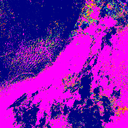
var dataset = ee.ImageCollection('NOAA/VIIRS/001/VNP43IA2')
                .filter(ee.Filter.date('2021-06-01', '2021-06-03'));

var visualization = {
  bands: ['BRDF_Albedo_ValidObs_I1'],
  min: 35550,
  max: 45535,
  palette: [
    '000080', '0000d9', '4000ff', '8000ff', '0080ff', '00ffff',
    '00ff80', '80ff00', 'daff00', 'ffff00', 'fff500', 'ffda00',
    'ffb000', 'ffa400', 'ff4f00', 'ff2500', 'ff0a00', 'ff00ff',
  ]
};

Map.setCenter(89, 58, 6);

Map.addLayer(dataset, visualization, 'Days of valid observation for band I1');