- 利用可能なデータセットの期間
- 2025-04-07T00:00:00Z–2026-06-28T10:20:21Z
- データセット プロデューサー
- NOAA
- 観測間隔
- 10 分
- タグ
説明
Fire(HSC)プロダクトには 4 枚の画像が含まれています。1 枚は火災マスクの形式で、残りの 3 枚は火災の温度、火災の範囲、火災の放射エネルギーを特定するピクセル値が含まれています。
ABI L2+ FHS メタデータ マスクは、FHS アルゴリズムに対する地球ナビゲーションされたすべてのピクセルに、その配置を示すフラグを割り当てます。誤報に対する許容度が最も低い運用ユーザーは、「処理済み」と「飽和状態」のカテゴリ(マスクコード 10、11、30、31)に注目する必要がありますが、これらのカテゴリ内でも誤報が発生する可能性があります。
GOES-19 の運用データ生成は 2025 年 4 月 7 日に開始されました。この日付より前のデータはすべて暫定値です。
NOAA は、推奨されるカテゴリ、カラーマップ、可視化用に次のスクリプトを提供しています。
NOAA の衛星・プロダクト運用局には、ステータス更新情報が掲載された衛星に関する一般的なメッセージ チャンネルがあります。
バンド
バンド
ピクセルサイズ: 2,000 メートル(すべてのバンド)
| 名前 | 単位 | 最小 | 最大 | スケール | オフセット | ピクセルサイズ | 説明 |
|---|---|---|---|---|---|---|---|
Area |
m^2 | 0* | 16723* | 60.98 | 4000 | 2,000 メートル | 火災の範囲 |
Temp |
K | 0* | 32642* | 0.0549367 | 400 | 2,000 メートル | 火災の温度 |
Mask |
2,000 メートル | 火災マスクのカテゴリ。火災マスク画像内のピクセル値は、火災カテゴリと、アルゴリズムの実行に関連付けられた診断情報を表します。6 つの火災カテゴリには、良質の火災ピクセルまたは時間的にフィルタリングされた良質の火災ピクセル、飽和した火災ピクセルまたは時間的にフィルタリングされた飽和した火災ピクセル、雲の影響を受けている火災ピクセルまたは時間的にフィルタリングされた雲の影響を受けている火災ピクセル、火災の可能性が高いピクセルまたは時間的にフィルタリングされた火災の可能性が高いピクセル、火災の可能性が中程度のピクセルまたは時間的にフィルタリングされた火災の可能性が高いピクセル、火災の可能性が低いまたは時間的にフィルタリングされた火災の可能性が高いが含まれます。時間的にフィルタリングされた火災ピクセルは、空間的、時間的に近接している火災ピクセルから得られたものです。 |
|||||
Power |
MW | 0 | 200000 | 2,000 メートル | 火災の放射エネルギー |
||
DQF |
0 | 5 | 2,000 メートル | データ品質フラグ |
マスククラス テーブル
| 値 | 色 | 説明 |
|---|---|---|
| 10 | red | 処理済みの火災 |
| 11 | white | 飽和した火災 |
| 12 | slategray | 雲の影響を受けている火災 |
| 13 | orange | 火災の可能性が高い |
| 14 | violet | 火災の可能性が中程度 |
| 15 | blue | 火災の可能性が低い |
| 30 | darkred | 処理済みの火災(フィルタリング) |
| 31 | ゴーストホワイト | 飽和した火災(フィルタリング) |
| 32 | ダークスレートグレー | 雲の影響を受けている火災(フィルタリング) |
| 33 | ダークオレンジ | 火災の可能性が高い(フィルタリング) |
| 34 | ダークバイオレット | 火災の可能性が中程度(フィルタリング) |
| 35 | ダークブルー | 火災の可能性が低い(フィルタリング) |
DQF クラステーブル
| 値 | 色 | 説明 |
|---|---|---|
| 0 | #ffffff | 良質の火災 |
| 1 | #ff00ff | 火災のない良質な土地 |
| 2 | #0000ff | 雲に遮られたため無効 |
| 3 | #00ffff | 地表の種類、太陽光の反射、LZA しきい値の超過、地球外、入力データの欠落が原因で無効 |
| 4 | #ffff00 | 入力データが正しくないため無効 |
| 5 | #ff0000 | アルゴリズムの失敗のため無効 |
利用規約
利用規約
NOAA のデータ、情報、プロダクトは、配信方法にかかわらず、著作権の対象ではなく、一般ユーザーによるその後の使用に制限はありません。取得したデータは、合法な目的であればどのような用途にも使用できます。
引用
Early characterization of the active fire detection products derived from the next generation NPOESS/VIIRS and GOES-R/ABI instruments. Schroeder, W., Csiszar, I., et al, (2010), Early characterization of the active fire detection products derived from the next generation NPOESS/VIIRS and GOES-R/ABI instruments, paper presented at 2010 IEEE International Geoscience and Remote Sensing Symposium (IGARSS), Honolulu, HI. doi:10.1109/IGARSS.2010.5650863
Schmit, T., Griffith, P., et al、(2016)、A closer look at the ABI on the GOES-R series(GOES-R シリーズ上の ABI の詳細な検討)、Bull。 Amer. Meteor. Soc.、98(4), 681-698。 doi:10.1175/BAMS-D-15-00230.1
DOI
Earth Engine で探索する
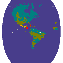
コードエディタ(JavaScript)
// NOAA GOES-19 full disk fire product for a single time slice.

var image = ee.Image('NOAA/GOES/19/FDCF/2025097022020500000');
var fireAreaImage = image.select('Area');
var temperatureImage = image.select('Temp');
var dataQualityFlagsImage = image.select('DQF');

var xMin = -142;  // On station as GOES-E
var xMax = xMin + 135;
Map.setCenter((xMin + xMax) / 2, 15, 3);
var geometry = ee.Geometry.Rectangle([xMin, -65, xMax, 65], null, true);

var dataQualityFlagsVis = {
  min: 0,
  max: 5,
  palette: [
    'blanchedalmond',  // Good quality fire pixel
    'olive',           // Good quality fire free land
    'teal',            // Opaque cloud
    'darkslateblue',   // Bad surface type, sunglint, LZA threshold exceeded,
                       // off Earth, or missing input data
    'lemonchiffon',    // Bad input data
    'burlywood'        // Algorithm failure
  ]
};
Map.addLayer(
    dataQualityFlagsImage, dataQualityFlagsVis, 'Data Quality Flags (DQF)');

var fireAreaVectors = fireAreaImage.reduceToVectors({
  geometry: geometry,
  scale: 2000,
  geometryType: 'centroid',
  labelProperty: 'area',
  maxPixels: 1e10,
});
// Fires are small enough that they are difficult to see at the scale of
// an entire GOES image.  Buffer fires based on area to make them stand out.
var fireAreaFeatureCollection = fireAreaVectors.map(function(feature) {
  return feature.buffer(feature.getNumber('area').add(1).pow(1.76));
});
Map.addLayer(fireAreaFeatureCollection, {color: 'orange'}, 'Fire area (orange)');

var temperatureVector = temperatureImage.reduceToVectors({
  geometry: geometry,
  scale: 2000,
  geometryType: 'centroid',
  labelProperty: 'temp',
  maxPixels: 1e10,
});
// Buffer fires based on temperature to make them stand out.
var temperature = temperatureVector.map(function(feature) {
  return feature.buffer(feature.getNumber('temp').add(2).pow(1.3));
});
Map.addLayer(temperature, {color: 'red'}, 'Temperature (red)');