- 資料集開放期間
- 2025-04-07T00:00:00Z–2026-06-25T05:26:17.200000Z
- 資料集產生者
- NOAA
- 觀測頻率
- 10 分鐘
- 標記
說明
GOES 衛星是由 NOAA 營運的地球靜止天氣衛星。
Fire (HSC) 產品包含四張圖片:一張是火災遮罩,另外三張則以像素值標示火災溫度、火災面積和火災輻射功率。
ABI L2+ FHS 中繼資料遮罩會為每個地球導引像素指派標記,指示 FHS 演算法運算出的分類。如果作業人員對誤報只有最低容忍度,應著重於「已處理」和「飽和」類別 (遮罩代碼 10、11、30 和 31),但這些類別仍可能出現誤報。
GOES-19 的作業資料製作於 2025 年 4 月 7 日開始。該日期前的任何資料僅為暫時性資料。
NOAA 提供下列指令碼,適用於建議類別、顏色對照和視覺化效果:
NOAA 的衛星及產品操作辦公室設有「一般衛星訊息」資訊管道,提供狀態更新。
頻帶
波段
像素大小:2000 公尺 (所有頻段)
| 名稱 | 單位 | 最小值 | 最大值 | 規模 | 偏移 | 像素大小 | 說明 |
|---|---|---|---|---|---|---|---|
Area |
m^2 | 0* | 16723* | 60.98 | 4000 | 2000 公尺 | 火災面積 |
Temp |
K | 0* | 32642* | 0.0549367 | 400 | 2000 公尺 | 火災溫度 |
Mask |
2000 公尺 | 火災遮罩類別。火災遮罩圖像中的像素值會識別火災類別,以及與演算法執行相關的診斷資訊。這六個火災類別包括:品質良好或經過時間濾波的品質良好火災像素;飽和火災像素或經過時間濾波的飽和火災像素;雲遮蔽或經過時間濾波的雲層汙染火災像素;高機率或經過時間濾波的高機率火災像素;中機率或經過時間濾波的高機率火災像素;低機率或經過時間濾波的高機率火災像素。經過時間濾波的火災像素是指在空間和時間上都非常接近的火災像素。 |
|||||
Power |
MW | 0 | 200000 | 2000 公尺 | 火災輻射功率 |
||
DQF |
0 | 5 | 2000 公尺 | 資料品質標記 |
遮罩類別表
| 值 | 顏色 | 說明 |
|---|---|---|
| 10 | 紅色 | 已處理火災 |
| 11 | 白色 | 飽和火災 |
| 12 | 灰色 | 雲遮蔽火災 |
| 13 | 橘色 | 高機率火災 |
| 14 | 紫色 | 中機率火災 |
| 15 | 藍色 | 低機率火災 |
| 30 | 深紅色 | 經過濾波的已處理火災 |
| 31 | 淺灰白 | 經過濾波的飽和火災 |
| 32 | 深灰色 | 經過濾波的雲遮蔽火災 |
| 33 | 深橘色 | 經過濾波的高機率火災 |
| 34 | 深紫色 | 經過濾波的中機率火災 |
| 35 | 深藍色 | 經過濾波的低機率火災 |
DQF 類別表
| 值 | 顏色 | 說明 |
|---|---|---|
| 0 | #ffffff | 品質良好,火災 |
| 1 | #ff00ff | 品質良好,無火土地 |
| 2 | #0000ff | 無效,因不透明雲層 |
| 3 | #00ffff | 無效,因地表類型、陽光、超出 LZA 門檻、不在地球上或缺少輸入資料 |
| 4 | #ffff00 | 無效,因輸入資料有誤 |
| 5 | #ff0000 | 無效,因演算法失敗 |
使用條款
使用條款
無論傳送方式為何,NOAA 資料、資訊和產品均不受著作權限制,可供大眾隨意使用,且取得前述資源後,可用於合法用途。
參考資料
Early characterization of the active fire detection products derived from the next generation NPOESS/VIIRS and GOES-R/ABI instruments. Schroeder, W., Csiszar, I. 等人 (2010 年)。〈Early characterization of the active fire detection products derived from the next generation NPOESS/VIIRS and GOES-R/ABI instruments〉論文發表於 2010 年 IEEE International Geoscience and Remote Sensing Symposium (IGARSS),夏威夷檀香山。 doi:10.1109/IGARSS.2010.5650863
Schmit, T., Griffith, P. 等人 (2016 年),〈A closer look at the ABI on the GOES-R series〉,《美國氣象學會公報》,98(4),681-698。 doi:10.1175/BAMS-D-15-00230.1
DOI
使用 Earth Engine 探索
程式碼編輯器 (JavaScript)
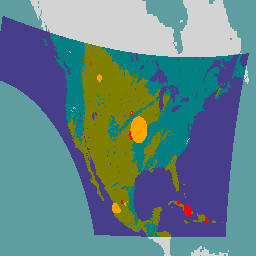
// NOAA GOES-19 conterminous fire product for a single time slice.

var image = ee.Image('NOAA/GOES/19/FDCC/2025097000117300000');

var area = image.select('Area');
var temp = image.select('Temp');
var dqf = image.select('DQF');

Map.centerObject(image, 3);
var xMin = -145;
var yMin = 15;
var xMax = -55;
var yMax = 54;
Map.setCenter((xMin + xMax) / 2, 15, 3);
var geometry = ee.Geometry.Rectangle([xMin, yMin, xMax, yMax], null, true);


var DQFVis = {
  min: 0,
  max: 5,
  palette: [
    'blanchedalmond',  // Good quality fire pixel
    'olive',           // Good quality fire free land
    'teal',            // Opaque cloud
                       // Bad surface type, sunglint, LZA threshold exceeded,
    'darkslateblue',   // off Earth, or missing input data
    'lemonchiffon',    // Bad input data
    'burlywood'        // Algorithm failure
  ]};
Map.addLayer(dqf, DQFVis, 'DQF');

// Fires are small enough that they are difficult to see at the scale of
// an entire GOES image.  Buffer fires based on area to make them stand out.
var area = area.reduceToVectors({
  geometry: geometry,
  scale: 2000,
  geometryType: 'centroid',
  labelProperty: 'area',
  maxPixels: 1e10,
}).map(function(feature){
  return feature.buffer(ee.Number(feature.get('area')).add(1).pow(1.4));
});
Map.addLayer(area, {color: 'orange'}, 'area');

// Buffer fires based on temperature to make them stand out.
var temp = temp.reduceToVectors({
  geometry: geometry,
  scale: 2000,
  geometryType: 'centroid',
  labelProperty: 'temp',
  maxPixels: 1e10,
}).map(function(feature){
  return feature.buffer(ee.Number(feature.get('temp')).add(2).pow(1.2));
});
Map.addLayer(temp, {color: 'red'}, 'temp');