
- זמינות קבוצת הנתונים
- 2015-07-01T00:00:00Z–2026-10-13T06:00:00Z
- מפיק קבוצת הנתונים
- NOAA/NCEP/EMC
- קצב
- 6 שעות
- תגים
תיאור
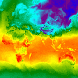
מערכת החיזוי הגלובלית (GFS) היא מודל לחיזוי מזג האוויר שנוצר על ידי National Centers for Environmental Prediction (המרכזים הלאומיים לחיזוי סביבתי, NCEP). מערך הנתונים של GFS מורכב מפלט נבחר של מודלים (שמתוארים בהמשך) כמשתני חיזוי ברשת. התחזיות ל-384 שעות, עם מרווחי תחזית של שעה (עד 120 שעות) ו-3 שעות (אחרי 120 שעות), נוצרות ברזולוציה זמנית של 6 שעות (כלומר, מתעדכנות ארבע פעמים ביום). כדי לבחור את הנתונים הרצויים, משתמשים במאפיינים creation_time ו-forecast_time.
GFS הוא מודל משולב שמורכב ממודל אטמוספרי, מודל אוקיינוס, מודל קרקע/אדמה ומודל קרח ימי, שפועלים יחד כדי לספק תמונה מדויקת של תנאי מזג האוויר. שימו לב שהמודל הזה עשוי להשתנות. מידע נוסף זמין בהיסטוריה של שינויים אחרונים במערכת הגלובלית של תחזיות וניתוחים ובמאמרי העזרה. יכולות להיות תנודות משמעותיות משעה לשעה ומיום ליום, שדורשות שימוש בטכניקות להפחתת רעשים לפני הניתוח.
שימו לב שהשעות והמרווחים הזמינים בתחזית לגבי זמינות שטחי הפרסום השתנו עם הזמן:
- מ-1 באפריל 2015 עד 9 ביולי 2017: תחזיות ל-36 שעות, לא כולל שעה 0, במרווחים של 3 שעות.
- מ-9 ביולי 2017 עד 11 ביוני 2021: תחזיות ל-384 שעות, במרווחים של שעה אחת משעה 0 עד 120, במרווחים של 3 שעות משעה 120 עד 240 ובמרווחים של 12 שעות משעה 240 עד 384.
- מ-2021/06/12: תחזיות ל-384 שעות, במרווחים של שעה אחת בין שעות 0 ל-120, ובמרווחים של 3 שעות בין שעות 120 ל-384.
חלק מהטווחים זמינים רק החל מ-15 בינואר 2025, כפי שמצוין בתיאורי הטווחים.
תחום תדרים
תחום תדרים
גודל הפיקסל: 27,830 מטרים (כל הרצועות)
| שם | יחידות | מינימום | מקסימום | גודל הפיקסל | תיאור |
|---|---|---|---|---|---|
temperature_2m_above_ground |
°C | -69.18* | 52.25* | 27,830 מטרים | הטמפרטורה בגובה 2 מטרים מעל פני הקרקע |
specific_humidity_2m_above_ground |
אחוז מסה | 0* | 0.03* | 27,830 מטרים | לחות ספציפית בגובה 2 מטרים מעל פני הקרקע |
dew_point_temperature_2m_above_ground |
°C | -81.05* | 29.05* | 27,830 מטרים | טמפרטורת נקודת הטל בגובה 2 מטרים מעל פני השטח (זמינה החל מ-15 בינואר 2025) |
relative_humidity_2m_above_ground |
% | 1* | 100.05* | 27,830 מטרים | לחות יחסית בגובה 2 מטרים מעל פני הקרקע |
maximum_temperature_2m_above_ground |
°C | -60.73* | 59.28* | 27,830 מטרים | טמפרטורה מקסימלית בגובה 2 מטרים מעל פני הקרקע (זמינה החל מ-15 בינואר 2025, אבל רק לנכסים עם forecast_hours > 0) |
minimum_temperature_2m_above_ground |
°C | -63.78* | 59.39* | 27,830 מטרים | הטמפרטורה המינימלית בגובה 2 מטרים מעל פני הקרקע (הנתון זמין החל מ-15 בינואר 2025, אבל רק לנכסים עם forecast_hours > 0) |
u_component_of_wind_10m_above_ground |
מ"ש | -60.73* | 59.28* | 27,830 מטרים | רכיב U של הרוח בגובה 10 מטרים מעל פני הקרקע |
v_component_of_wind_10m_above_ground |
מ"ש | -63.78* | 59.39* | 27,830 מטרים | רכיב V של הרוח בגובה 10 מטרים מעל פני השטח |
total_precipitation_surface |
ק"ג למ"ר | 0* | 626.75* | 27,830 מטרים | כמות המשקעים המצטברת על פני השטח ב-1 עד 6 השעות הקודמות, בהתאם לערך של המאפיין forecast_hours לפי הנוסחה ((F - 1) % 6) + 1 (ורק לנכסים עם forecast_hours > 0). לכן, כדי לחשב את כמות המשקעים הכוללת בשעה X, צריך להימנע מספירה כפולה ולסכום רק את הערכים של forecast_hours שהם כפולות של 6, בתוספת השארית שנותרה עד שמגיעים ל-X. המשמעות היא שצריך להחסיר את הערך של השעה הקודמת כדי לקבוע את כמות המשקעים רק בשעה X, אלא אם X היא השעה הראשונה בחלון של 6 שעות. |
precipitable_water_entire_atmosphere |
ק"ג למ"ר | 0* | 100* | 27,830 מטרים | כמות המים שניתן להמטיר מכל האטמוספירה |
u_component_of_wind_planetary_boundary_layer |
מ"ש | -66.8* | 62.18* | 27,830 מטרים | רכיב U של שכבת הגבולות הפלנטריים של הרוח (זמין החל מ-15 בינואר 2025) |
v_component_of_wind_planetary_boundary_layer |
מ"ש | -63.08* | 57.6* | 27,830 מטרים | רכיב V של הרוח בשכבת הגבולות הפלנטרית (זמין החל מ-15 בינואר 2025) |
gust |
מ"ש | 0* | 57.41* | 27,830 מטרים | מהירות הרוח (משב) (זמין החל מ-15 בינואר 2025) |
precipitation_rate |
ק"ג/מ"ר/שנייה | 0* | 0.032* | 27,830 מטרים | שיעור המשקעים (זמין החל מ-15 בינואר 2025) |
haines_index |
2* | 6* | 27,830 מטרים | מדד היינס (זמין החל מ-15 בינואר 2025) |
|
ventilation_rate |
מ"ר לשנייה | 0* | 234000* | 27,830 מטרים | קצב האוורור (זמין החל מ-15.01.2025) |
total_cloud_cover_entire_atmosphere |
% | 0* | 100* | 27,830 מטרים | כיסוי העננים הכולל באטמוספירה כולה (בעבר רק לנכסים עם forecast_hours > 0, אבל זמין לנכסים עם forecast_hours == 0 החל מ-2025/01/15) |
downward_shortwave_radiation_flux |
W/m^2 | 0* | 1230* | 27,830 מטרים | שטף קרינת גלים קצרים כלפי מטה (רק לנכסים עם forecast_hours > 0) |
downward_longwave_radiation_flux |
W/m^2 | 0* | 100* | 27,830 מטרים | שטף קרינה ארוכת גל כלפי מטה (זמין החל מ-15 בינואר 2025, אבל רק לנכסים עם forecast_hours > 0) |
upward_shortwave_radiation_flux |
W/m^2 | 0* | 1230* | 27,830 מטרים | שטף קרינת גלים קצרים כלפי מעלה (זמין החל מ-15 בינואר 2025, אבל רק לנכסים עם forecast_hours > 0) |
upward_longwave_radiation_flux |
W/m^2 | 0* | 100* | 27,830 מטרים | שטף קרינה ארוכת גל כלפי מעלה (זמין החל מ-15 בינואר 2025, אבל רק לנכסים עם forecast_hours > 0) |
planetary_boundary_layer_height |
m | 7.77* | 6,312.67* | 27,830 מטרים | גובה שכבת הגבולות הפלנטריים (זמין החל מ-15 בינואר 2025) |
מאפייני תמונה
מאפייני תמונה
| שם | סוג | תיאור |
|---|---|---|
| creation_time | נקודה צפה בדיוק כפול (Double Precision Floating Point) | מועד היצירה |
| forecast_hours | נקודה צפה בדיוק כפול (Double Precision Floating Point) | שעות התחזית |
| forecast_time | נקודה צפה בדיוק כפול (Double Precision Floating Point) | זמן התחזית |
תנאים והגבלות
תנאים והגבלות
הנתונים, המידע והמוצרים של NOAA, ללא קשר לשיטת המסירה, לא כפופים לזכויות יוצרים ואין הגבלות על השימוש בהם על ידי הציבור. אחרי שמקבלים אותם, אפשר להשתמש בהם לכל מטרה חוקית. הנתונים שצוינו הם נחלת הכלל ואנחנו מספקים אותם ללא הגבלה על השימוש וההפצה.
ציטוטים ביבליוגרפיים
Alpert, J., 2006 Sub-Grid Scale Mountain Blocking at NCEP, 20th Conf. WAF/16 Conf. NWP P2.4.
Alpert, J. C., S-Y. Hong ו-Y-J. Kim: 1996, Sensitivity of cyclogenesis to lower troposphere enhancement of gravity wave drag using the EMC MRF", Proc. 11 Conf. On NWP, Norfolk, 322-323.
Alpert,J,, M. Kanamitsu, P. M. Caplan, J. ז. Sela, G. ח. White ו-E. Kalnay, 1988: Mountain induced gravity wave drag parameterization in the NMC medium-range forecast model. Pre-prints, Eighth Conf. on Numerical Weather Prediction, Baltimore, MD, Amer. Meteor. Soc., 726-733.
Buehner, M., י. Morneau ו-C. Charette, 2013: Four-dimensional ensemble-variational data assimilation for global deterministic weather prediction. Nonlinear Processes Geophys., 20, 669-682.
Chun, H.-Y., and J.-J. Baik, 1998: Momentum Flux by Thermally Induced Internal Gravity Waves and Its Approximation for Large-Scale Models. י. Atmos. Sci., 55, 3299-3310.
Chun, H.-Y., Song, I.-S., Baik, J.-J. and Y.-J. קים. 2004: השפעה של פרמטריזציה של גרר גלי כבידה שנכפה על ידי הסעה ב-NCAR CCM3. י. Climate, 17, 3530-3547.
Chun, H.-Y., Song, M.-D., Kim, J.-W., and J.-J. Baik, 2001: Effects of Gravity Wave Drag Induced by Cumulus Convection on the Atmospheric General Circulation. י. Atmos. Sci., 58, 302-319.
Clough, S.A., M.W. Shephard, E.J. Mlawer, J.S. Delamere, M.J. Iacono, K.Cady-Pereira, S. Boukabara, and P.D. Brown, 2005: Atmospheric radiative transfer modeling: A summary of the AER codes, J. כמות Spectrosc. קרינה Transfer, 91, 233-244. doi:10.1016/j.jqsrt.2004.05.058
Ebert, E.E., and J.A. Curry, 1992: A parameterization of ice cloud optical properties for climate models. י. Geophys. Res., 97, 3831-3836.
Fu, Q., 1996: An Accurate Parameterization of the Solar Radiative Properties of Cirrus Clouds for Climate Models. י. Climate, 9, 2058-2082.
Han, J., and H.-L. Pan, 2006: Sensitivity of hurricane intensity forecast to convective momentum transport parameterization. מזג אוויר ביום שני הכנסות, 134, 664-674.
Han, J., and H.-L. Pan, 2011: Revision of convection and vertical diffusion schemes in the NCEP global forecast system. Weather and Forecasting, 26, 520-533.
Han, J., M. Witek, J. Teixeira, R. Sun, H.-L. Pan, J. K. Fletcher, and C. S. Bretherton, 2016: Implementation in the NCEP GFS of a hybrid eddy-diffusivity mass-flux (EDMF) boundary layer parameterization with dissipative heating and modified stable boundary layer mixing. Weather and Forecasting, 31, 341-352.
Hou, Y., S. Moorthi and K. Campana, 2002: Parameterization of Solar Radiation Transfer in the NCEP Models, NCEP Office Note #441, pp46. זמין כאן
Hu, Y.X., and K. Stamnes, 1993: פרמטריזציה מדויקת של מאפייני הקרינה של ענני מים שמתאימה לשימוש במודלים אקלימיים. י. Climate, 6, 728-74.
Iacono, M.J., E.J. Mlawer, S.A. Clough, and J.-J. Morcrette, 2000: Impact of an improved longwave radiation model, RRTM, on the energy budget and thermodynamic properties of the NCAR community climate model, CCM3, J. Geophys. Res., 105(D11), 14,873-14,890.2.
Johansson, Ake, 2008: Convectively Forced Gravity Wave Drag in the NCEP Global Weather and Climate Forecast Systems, SAIC/Environmental Modelling Center internal report.
Juang, H-M, et al. 2014:Regional Spectral Model workshop in memory of John Roads and Masao Kanamitsu, BAMS, A. בוצע. Soc, ES61-ES65.
Kim, Y.-J., and A. Arakawa (1995), Improvement of orographic gravity wave parameterization using a mesoscale gravity-wave model, J. Atmos. Sci.,52, 875-1902.
Kleist, D. T., 2012: An evaluation of hybrid variational-ensemble data assimilation for the NCEP GFS , עבודת דוקטורט, המחלקה למדעי האטמוספרה והאוקיינוס, אוניברסיטת מרילנד בקולג' פארק, 149 עמודים.
Lott, F and M. י. Miller: 1997, "A new subgrid-scale orographic drag parameterization: Its formulation and testing", QJRMS, 123, pp101-127.
Mlawer, E.J., S.J. Taubman, P.D. Brown, M.J. Iacono, and S.A. Clough, 1997: Radiative transfer for inhomogeneous atmospheres: RRTM, a validated correlated-k model for the longwave. י. Geophys. Res., 102, 16663-16682.
Sela, J., 2009: הטמעה של קואורדינטה היברידית של לחץ סיגמה ב-GFS. NCEP Office Note #461, pp25.
Sela, J., 2010: גזירת משוואות מודל חצי-לגראנז'יאני של קואורדינטה היברידית של לחץ סיגמא עבור GFS. NCEP Office Note #462 pp31.
Yang, F., 2009: On the Negative Water Vapor in the NCEP GFS: Sources and Solution. 23rd Conference on Weather Analysis and Forecasting/19th Conference on Numerical Weather Prediction, 1-5 June 2009, Omaha, NE.
Yang, F., K. Mitchell, Y. Hou, Y. Dai, X. Zeng, Z. Wang ו-X. Liang, 2008: Dependence of land surface albedo on solar zenith angle: observations and model parameterizations. Journal of Applied Meteorology and Climatology.No.11, Vol 47, 2963-2982.
מזהי DOI
סיור עם פלטפורמת Earth Engine
Code Editor (JavaScript)
var dataset = ee.ImageCollection('NOAA/GFS0P25')
                  .filter(ee.Filter.date('2018-03-01', '2018-03-02'));
var temperatureAboveGround = dataset.select('temperature_2m_above_ground');
var visParams = {
  min: -40.0,
  max: 35.0,
  palette: ['blue', 'purple', 'cyan', 'green', 'yellow', 'red'],
};
Map.setCenter(71.72, 52.48, 3.0);
Map.addLayer(temperatureAboveGround, visParams, 'Temperature Above Ground');
import ee
import geemap.core as geemap
Colab (Python)
dataset = ee.ImageCollection('NOAA/GFS0P25').filter(
    ee.Filter.date('2018-03-01', '2018-03-02')
)

temperature_above_ground = dataset.select('temperature_2m_above_ground')

vis_params = {
    'min': -40.0,
    'max': 35.0,
    'palette': ['blue', 'purple', 'cyan', 'green', 'yellow', 'red'],
}

m = geemap.Map()
m.set_center(71.72, 52.48, 3.0)
m.add_layer(temperature_above_ground, vis_params, 'Temperature Above Ground')
m