- Disponibilidad del conjunto de datos
- 1979-01-01T00:00:00Z–2025-12-02T00:00:00Z
- Proveedor del conjunto de datos
- Centros Nacionales de Predicción Ambiental (NCEP) del Servicio Nacional del Clima (NWS) de la NOAA
- Cadencia
- 6 horas
- Etiquetas
Descripción
El Sistema de Previsión Climática (CFS) de los Centros Nacionales de Predicción Ambiental (NCEP) es un modelo completamente acoplado que representa la interacción entre la atmósfera, los océanos, la tierra y el hielo marino de la Tierra. El CFS se desarrolló en el Centro de Modelado Ambiental (EMC) del NCEP. El CFS operativo se actualizó a la versión 2 (CFSv2) el 30 de marzo de 2011.
Las previsiones se inicializan cuatro veces al día (0000, 0600, 1200 y 1800 UTC). Este es el mismo modelo que se usó para crear el reanálisis del Sistema de Pronóstico Climático (CFS) del NCEP, y el propósito del conjunto de datos de CFSv2 es extender el CFSR. Solo transferimos un subconjunto de bandas de los archivos que coinciden con cdas1.t??z.sfluxgrbf06.grib2.
Para obtener más información sobre el CFS, consulta el sitio del CFS de la NOAA.
Bandas
Tamaño de píxel
22,264 metros
Bandas
| Nombre | Unidades | Mín. | Máx. | Tamaño de píxel | Descripción |
|---|---|---|---|---|---|
Downward_Long-Wave_Radp_Flux_surface_6_Hour_Average |
W/m² | 41.76* | 532.67* | metros | Flujo de radiación de onda larga descendente en la superficie, promedio de 6 horas |
Downward_Short-Wave_Radiation_Flux_surface_6_Hour_Average |
W/m² | 0* | 1125.23* | metros | Flujo de radiación de onda corta descendente en la superficie, promedio de 6 horas |
Geopotential_height_surface |
gpm | -292* | 5938.65* | metros | Altura geopotencial en la superficie |
Latent_heat_net_flux_surface_6_Hour_Average |
W/m² | -628* | 2357* | metros | Flujo neto de calor latente en la superficie, promedio de 6 horas |
Maximum_specific_humidity_at_2m_height_above_ground_6_Hour_Interval |
Fracción de masa | 0* | 0.1* | metros | Humedad específica máxima a 2 m sobre el nivel del suelo, intervalo de 6 horas |
Maximum_temperature_height_above_ground_6_Hour_Interval |
K | 189.8* | 334.89* | metros | Temperatura máxima a 2 m sobre el nivel del suelo, intervalo de 6 horas |
Minimum_specific_humidity_at_2m_height_above_ground_6_Hour_Interval |
Fracción de masa | 0* | 0.02* | metros | Humedad específica mínima a 2 m sobre el nivel del suelo, intervalo de 6 horas |
Minimum_temperature_height_above_ground_6_Hour_Interval |
K | 188.39* | 324.39* | metros | Temperatura mínima a 2 m sobre el nivel del suelo, intervalo de 6 horas |
Potential_Evaporation_Rate_surface_6_Hour_Average |
W/m² | -202* | 6277* | metros | Tasa de evaporación potencial en la superficie, promedio de 6 horas |
Precipitation_rate_surface_6_Hour_Average |
kg/m²s | 0* | 0.03* | metros | Tasa de precipitación en la superficie, promedio de 6 horas |
Pressure_surface |
Pa | 47,200* | 109,180* | metros | Presión en la superficie |
Sensible_heat_net_flux_surface_6_Hour_Average |
W/m² | -2295* | 3112* | metros | Flujo neto de calor sensible en la superficie, promedio de 6 horas |
Specific_humidity_height_above_ground |
Fracción de masa | 0* | 0.06* | metros | Humedad específica a 2 m sobre el nivel del suelo |
Temperature_height_above_ground |
K | 188.96* | 328.68* | metros | Temperatura a 2 m sobre el nivel del suelo |
u-component_of_wind_height_above_ground |
m/s | -57.2* | 57.99* | metros | Componente U del viento a 10 m sobre el nivel del suelo |
Upward_Long-Wave_Radp_Flux_surface_6_Hour_Average |
W/m² | 59* | 757* | metros | Flujo de radiación de onda larga ascendente en la superficie, promedio de 6 horas |
Upward_Short-Wave_Radiation_Flux_surface_6_Hour_Average |
W/m² | 0* | 812* | metros | Flujo de radiación de onda corta ascendente en la superficie, promedio de 6 horas |
v-component_of_wind_height_above_ground |
m/s | -53.09* | 57.11* | metros | Componente V del viento a 10 m sobre el nivel del suelo |
Volumetric_Soil_Moisture_Content_depth_below_surface_layer_5_cm |
Fracción | 0.02* | 1* | metros | Contenido de humedad volumétrica del suelo a 5 cm por debajo de la capa superficial |
Volumetric_Soil_Moisture_Content_depth_below_surface_layer_25_cm |
Fracción | 0.02* | 1* | metros | Contenido de humedad volumétrica del suelo a 25 cm por debajo de la capa superficial |
Volumetric_Soil_Moisture_Content_depth_below_surface_layer_70_cm |
Fracción | 0.02* | 1* | metros | Contenido de humedad volumétrica del suelo a 70 cm por debajo de la capa superficial |
Volumetric_Soil_Moisture_Content_depth_below_surface_layer_150_cm |
Fracción | 0.02* | 1* | metros | Contenido de humedad volumétrica del suelo a 150 cm por debajo de la capa superficial |
Propiedades de la imagen
Propiedades de la imagen
| Nombre | Tipo | Descripción |
|---|---|---|
| end_hour | DOUBLE | Hora de finalización |
| start_hour | DOUBLE | Hora de inicio |
Condiciones de Uso
Condiciones de Uso
Los datos, la información y los productos de la NOAA, independientemente del método de entrega, no están sujetos a derechos de autor y no tienen restricciones sobre su uso público posterior. Una vez que se obtienen, se pueden usar para cualquier fin legal. Los datos anteriores son de dominio público y se proporcionan sin restricciones de uso ni distribución. Para obtener más información, visita el sitio de renuncia de responsabilidad de NWS.
Citas
Saha, S., et al. 2011, actualizado diariamente. Productos cada 6 horas del Sistema de pronóstico climático (CFSv2) versión 2 del NCEP. Archivo de datos de investigación en el Centro Nacional de Investigación Atmosférica, Laboratorio de Sistemas de Información y Computación. https://doi.org/10.5065/D61C1TXF. Consultado el dd de mmm de aaaa.
DOI
Explora con Earth Engine
Editor de código (JavaScript)
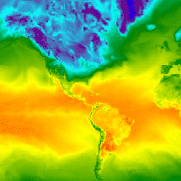
var dataset = ee.ImageCollection('NOAA/CFSV2/FOR6H')
                  .filter(ee.Filter.date('2018-03-01', '2018-03-14'));
var temperatureAboveGround = dataset.select('Temperature_height_above_ground');
var visParams = {
  min: 220.0,
  max: 310.0,
  palette: ['blue', 'purple', 'cyan', 'green', 'yellow', 'red'],
};
Map.setCenter(-88.6, 26.4, 1);
Map.addLayer(temperatureAboveGround, visParams, 'Temperature Above Ground');