Page Summary
-
The Sea Surface Temperature - WHOI dataset provides a high quality Climate Data Record of sea surface temperature over ice-free oceans.
-
This dataset is available from 1988-01-01 to 2021-08-31 with a 3-hour cadence.
-
The dataset includes sea surface temperature and quality control flags bands.
-
Data is publicly available and free to use with no restrictions.
- Dataset Availability
- 1988-01-01T00:00:00Z–2021-08-31T00:00:00Z
- Dataset Producer
- NOAA
- Cadence
- 3 Hours
- Tags
Description
The Sea Surface Temperature - WHOI dataset is part of the NOAA Ocean Surface Bundle (OSB) and provides a high quality Climate Data Record (CDR) of sea surface temperature over ice-free oceans.
The SST values are found through modeling the diurnal variability in combination with AVHRR observations of sea surface temperature.
Bands
Bands
Pixel size: 27830 meters (all bands)
| Name | Units | Min | Max | Pixel Size | Description | ||||||||||||||||||||||||||||||||||||||||||||||||||||||||||||||||||||||||||||||||||||||||||||||
|---|---|---|---|---|---|---|---|---|---|---|---|---|---|---|---|---|---|---|---|---|---|---|---|---|---|---|---|---|---|---|---|---|---|---|---|---|---|---|---|---|---|---|---|---|---|---|---|---|---|---|---|---|---|---|---|---|---|---|---|---|---|---|---|---|---|---|---|---|---|---|---|---|---|---|---|---|---|---|---|---|---|---|---|---|---|---|---|---|---|---|---|---|---|---|---|---|---|---|---|
sea_surface_temperature |
°C | -1.79* | 35* | 27830 meters | Optimum Interpolation Sea Surface Temperature (OISST), with a diurnal warming correction |
||||||||||||||||||||||||||||||||||||||||||||||||||||||||||||||||||||||||||||||||||||||||||||||
fill_missing_qc |
27830 meters | Quality control flags |
|||||||||||||||||||||||||||||||||||||||||||||||||||||||||||||||||||||||||||||||||||||||||||||||||
Terms of Use
Terms of Use
The NOAA CDR Program's official distribution point for CDRs is NOAA's National Climatic Data Center which provides sustained, open access and active data management of the CDR packages and related information in keeping with the United States' open data policies and practices as described in the President's Memorandum on "Open Data Policy" and pursuant to the Executive Order of May 9, 2013, "Making Open and Machine Readable the New Default for Government Information". In line with these policies, the CDR data sets are nonproprietary, publicly available, and no restrictions are placed upon their use. For more information, see the Fair Use of NOAA's CDR Data Sets, Algorithms and Documentation pdf.
Citations
Clayson, Carol Anne, Brown, Jeremiah, and NOAA CDR Program (2016). NOAA Climate Data Record Ocean Surface Bundle (OSB) Climate Data Record (CDR) of Sea Surface Temperature - WHOI, Version 2. [indicate subset used]. NOAA National Climatic Data Center. doi:10.7289/V5FB510W.
DOIs
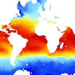
Explore with Earth Engine
Code Editor (JavaScript)
var dataset = ee.ImageCollection('NOAA/CDR/SST_WHOI/V2')
                  .filter(ee.Filter.date('2018-03-01', '2018-03-14'));
var seaSurfaceTemperature = dataset.select('sea_surface_temperature');
var visParams = {
  min: 0.0,
  max: 30.0,
  palette: [
    '040274', '040281', '0502a3', '0502b8', '0502ce', '0502e6',
    '0602ff', '235cb1', '307ef3', '269db1', '30c8e2', '32d3ef',
    '3be285', '3ff38f', '86e26f', '3ae237', 'b5e22e', 'd6e21f',
    'fff705', 'ffd611', 'ffb613', 'ff8b13', 'ff6e08', 'ff500d',
    'ff0000', 'de0101', 'c21301', 'a71001', '911003'
  ],
};
Map.setCenter(-4.92, -21.09, 2);
Map.addLayer(seaSurfaceTemperature, visParams, 'Sea Surface Temperature');