- Disponibilidad del conjunto de datos
- 1981-08-24T00:00:00Z–2023-12-30T21:35:08Z
- Proveedor del conjunto de datos
- NOAA
- Cadencia
- 12 horas
- Etiquetas
Descripción
El conjunto de datos de temperatura de la superficie del mar de AVHRR Pathfinder, versión 5.3 (PFV53), es una colección de datos globales de temperatura de la superficie del mar de 4 km, recopilados dos veces al día, que se producen en una asociación entre el Centro Nacional de Datos Oceanográficos de la NOAA y la Escuela Rosenstiel de Ciencias Marinas y Atmosféricas de la Universidad de Miami. El PFV53 se calculó a partir de los datos de los instrumentos AVHRR a bordo de la serie de satélites en órbita polar de la NOAA con un sistema completamente modernizado basado en SeaDAS. Los datos de PFV53 cumplen casi en un 100% con la versión 2.0 de la especificación de datos de GHRSST para los productos L3C y solo se desvían de ese estándar en que las variables "sses_bias", "sses_standard_deviation" y "sst_dtime" están vacías y, por lo tanto, no se incluyen en los recursos de EE. Los datos de PFV53 se recopilaron durante los períodos operativos de los satélites operativos ambientales polares (POES) NOAA-7 a NOAA-19, y están disponibles desde 1981 hasta 2014. Puedes encontrar más información en el sitio de Pathfinder de la NOAA.
Puedes encontrar detalles adicionales sobre las correas en la página de Especificaciones Técnicas.
Estos datos fueron proporcionados por el GHRSST y los Centros Nacionales de Información Ambiental (NCEI) de la NOAA de EE.UU. Este proyecto se financió en parte con una subvención del Programa de registros de datos climáticos (CDR) de la NOAA para satélites.
Bandas
Bandas
Tamaño de píxel: 4,000 metros (todas las bandas)
| Nombre | Unidades | Mín. | Máx. | Escala | Desplazamiento | Tamaño de los píxeles | Descripción | ||||||||||||||||||||||||||||||||||||||||||||||||||||||||||||||||||||||||||||||||||||||||||||
|---|---|---|---|---|---|---|---|---|---|---|---|---|---|---|---|---|---|---|---|---|---|---|---|---|---|---|---|---|---|---|---|---|---|---|---|---|---|---|---|---|---|---|---|---|---|---|---|---|---|---|---|---|---|---|---|---|---|---|---|---|---|---|---|---|---|---|---|---|---|---|---|---|---|---|---|---|---|---|---|---|---|---|---|---|---|---|---|---|---|---|---|---|---|---|---|---|---|---|---|
sea_surface_temperature |
K | -300* | 3999* | 0.01 | 273.15 | 4,000 metros | Temperatura cutánea del océano |
||||||||||||||||||||||||||||||||||||||||||||||||||||||||||||||||||||||||||||||||||||||||||||
dt_analysis |
K | -127* | 127* | 0.1 | 4,000 metros | Es la diferencia entre este SST y el del día anterior. |
|||||||||||||||||||||||||||||||||||||||||||||||||||||||||||||||||||||||||||||||||||||||||||||
wind_speed |
m/s | 0* | 47* | 4,000 metros | Estas velocidades del viento se crearon con el proyecto de comparación de modelos atmosféricos (AMIP-II) de reanálisis (R-2) del NCEP-DOE y representan vientos a 10 metros sobre la superficie del mar. |
||||||||||||||||||||||||||||||||||||||||||||||||||||||||||||||||||||||||||||||||||||||||||||||
sea_ice_fraction |
8* | 100* | 0.01 | 4,000 metros | Los datos de concentración de hielo marino se obtienen del conjunto de datos de reprocesamiento de la concentración global diaria de hielo marino accession.nodc.noaa.gov/0068294 de la Instalación de Aplicaciones Satelitales de Hielo Marino y Océanos de EUMETSAT (OSISAF) cuando estos datos están disponibles. Los datos se reproyectan y se interpolan desde su proyección estereográfica polar original con una resolución espacial de 10 km a la cuadrícula de 4 km de Pathfinder versión 5.3. Cuando los datos de OSISAF no están disponibles para ambos hemisferios en un día determinado, los datos de concentración de hielo marino se toman de la variable sea_ice_fraction que se encuentra en el producto SST DailyOI de L4 GHRSST de NOAA/NCDC y se interpolan de la cuadrícula DailyOI de 25 km a la cuadrícula Pathfinder versión 5.3 de 4 km. |
||||||||||||||||||||||||||||||||||||||||||||||||||||||||||||||||||||||||||||||||||||||||||||||
aerosol_dynamic_indicator |
-127* | 127* | 0.01 | 1.1 | 4,000 metros | Los datos del espesor óptico de aerosoles (100 km) se toman de los productos CLASS AERO100, que se crean a partir de las recuperaciones del espesor óptico del canal 1 del AVHRR de los datos de cobertura global (GAC) del AVHRR. Las mediciones del espesor óptico de aerosoles se interpolan desde su resolución original de 1 grado x 1 grado hasta la cuadrícula de 4 km de la versión 5.3 de Pathfinder. |
|||||||||||||||||||||||||||||||||||||||||||||||||||||||||||||||||||||||||||||||||||||||||||||
quality_level |
0 | 5 | 4,000 metros | Ten en cuenta que el sistema de procesamiento nativo de Pathfinder devuelve niveles de calidad que van del 0 al 7 (7 es la mejor calidad; -1 representa datos faltantes) y se convirtió en la medida de lo posible a los seis niveles que requiere GDS2 (del 0 al 5, donde 5 es el mejor). A continuación, se muestra la tabla de conversión:
El nivel de calidad original de Pathfinder se registra en la variable opcional pathfinder_quality_level. |
|||||||||||||||||||||||||||||||||||||||||||||||||||||||||||||||||||||||||||||||||||||||||||||||
pathfinder_quality_level |
0 | 7 | 4,000 metros | Niveles de calidad del sistema de procesamiento nativo de Pathfinder, que van del 0 al 7, donde 0 es el peor y 7 es el mejor. |
|||||||||||||||||||||||||||||||||||||||||||||||||||||||||||||||||||||||||||||||||||||||||||||||
l2p_flags |
4,000 metros | Se usa para especificar el tipo de datos de SST de entrada y pasar marcas nativas del conjunto de datos de SST de L2 de entrada. |
|||||||||||||||||||||||||||||||||||||||||||||||||||||||||||||||||||||||||||||||||||||||||||||||||
Propiedades de imágenes
Propiedades de la imagen
| Nombre | Tipo | Descripción |
|---|---|---|
| aerosol_dynamic_indicator_offset | DOUBLE | Ajuste del indicador dinámico de aerosol |
| aerosol_dynamic_indicator_scale | DOUBLE | Escala del indicador dinámico de aerosol |
| date_created | DOUBLE | Fecha de creación |
| day_or_night | STRING | De día y de noche |
| dt_analysis_scale | DOUBLE | Escala de análisis de Dt |
| orbit_node | STRING | Nodo Orbit |
| plataforma | STRING | Plataforma |
| principal_day_for_collated_orbits | STRING | Día principal para las órbitas recopiladas |
| principal_year_for_collated_orbits | DOUBLE | Año principal para las órbitas recopiladas |
| sea_ice_fraction_scale | DOUBLE | Escala de fracción de hielo marino |
| sea_surface_temperature_offset | DOUBLE | Desviación de la temperatura de la superficie marina |
| sea_surface_temperature_scale | DOUBLE | Escala de temperatura de la superficie marina |
| uuid | STRING | Identificador único universal |
Condiciones de Uso
Condiciones de Uso
Los datos, la información y los productos de la NOAA, independientemente del método de entrega, no están sujetos a derechos de autor y no tienen restricciones sobre su uso público posterior. Una vez que se obtienen, se pueden usar para cualquier fin legal. Los datos anteriores son de dominio público y se proporcionan sin restricciones de uso ni distribución. Para obtener más información, consulta la sección "constraints" en https://data.nodc.noaa.gov/cgi-bin/iso?id=gov.noaa.nodc:AVHRR_Pathfinder-NCEI-L3C-v5.3.
Citas
Baker-Yeboah, S., K. Saha, D. Zhang, K. S. Casey, R. Evans y K. A. Kilpatrick (2016). "Pathfinder Version 5.3 AVHRR Sea Surface Temperature Climate Data Record", Fall AGU 2016 Poster (manuscrito en curso)
DOI
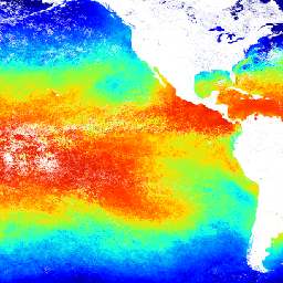
Explora con Earth Engine
Editor de código (JavaScript)
var dataset = ee.ImageCollection('NOAA/CDR/SST_PATHFINDER/V53')
                  .filter(ee.Filter.date('2014-05-01', '2014-05-14'));
var seaSurfaceTemperature = dataset.select('sea_surface_temperature');
var visParams = {
  min: 0.0,
  max: 2500.0,
  palette: [
    '030d81', '0519ff', '05e8ff', '11ff01', 'fbff01', 'ff9901', 'ff0000',
    'ad0000'
  ],
};
Map.setCenter(-121.99, -2.11, 2);
Map.addLayer(seaSurfaceTemperature, visParams, 'Sea Surface Temperature');