- ความพร้อมใช้งานของชุดข้อมูล
- 1981-09-01T00:00:00Z–2020-04-26T00:00:00Z
- ผู้ผลิตชุดข้อมูล
- NOAA
- ความถี่การบันทึก
- 1 วัน
- แท็ก
คำอธิบาย
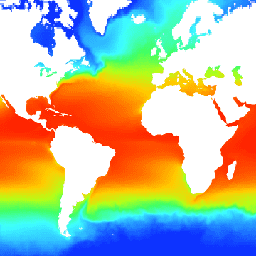
อุณหภูมิผิวน้ำทะเลที่เหมาะสมที่สุดรายวันของ NOAA ที่ 1/4 องศา (OISST) ให้ข้อมูลอุณหภูมิของมหาสมุทรที่สมบูรณ์ซึ่งสร้างขึ้นโดยการรวมการสังเกตที่ปรับอคติจากแพลตฟอร์มต่างๆ (ดาวเทียม เรือ ทุ่นลอย) ในตารางกริดทั่วโลกเป็นประจำ โดยมีการเติมช่องว่างด้วยการประมาณค่า ข้อมูลดาวเทียมจาก Advanced Very High Resolution Radiometer (AVHRR) เป็นอินพุตหลักที่ทำให้เราสามารถเก็บข้อมูลครอบคลุมทั้งมิติเวลาและพื้นที่ได้อย่างละเอียด ตั้งแต่ปลายปี 1981 จนถึงปัจจุบัน
ชุดข้อมูล OISST มีข้อมูลวันเดียวที่ประมวลผล 2 ครั้ง โดยจะเปิดตัวเวอร์ชันเบื้องต้นแบบเกือบเรียลไทม์ก่อน ซึ่งจะมีความล่าช้า 1 วัน และเวอร์ชันสุดท้าย ซึ่งจะมีความล่าช้า 14 วัน เวอร์ชันสุดท้ายจะใช้เวลาเพิ่มขึ้นเพื่อ ปรับการทำงานให้ลื่นไหลและการแก้ไขอคติแบบแบ่งโซน นอกเหนือจากการแทนที่เวอร์ชัน เบื้องต้น
ย่านความถี่
ย่านความถี่
ขนาดพิกเซล: 27830 เมตร (ทุกแถบ)
| ชื่อ | หน่วย | ต่ำสุด | สูงสุด | สเกล | ขนาดพิกเซล | คำอธิบาย |
|---|---|---|---|---|---|---|
sst |
°C | -180* | 3764* | 0.01 | 27830 เมตร | อุณหภูมิผิวน้ำทะเลรายวัน |
anom |
°C | -1887* | 1902* | 0.01 | 27830 เมตร | ความผิดปกติของอุณหภูมิ; OISST รายวันลบด้วยค่าเฉลี่ยทางภูมิอากาศ 30 ปี |
ice |
% | 1* | 100* | 0.01 | 27830 เมตร | ค่ามัธยฐาน 7 วันของความเข้มข้นของน้ำแข็งในทะเลรายวัน |
err |
°C | 11* | 171* | 0.01 | 27830 เมตร | ข้อผิดพลาดโดยประมาณ ส่วนเบี่ยงเบนมาตรฐานของอุณหภูมิพื้นผิวทะเลที่วิเคราะห์แล้ว |
พร็อพเพอร์ตี้รูปภาพ
พร็อพเพอร์ตี้รูปภาพ
| ชื่อ | ประเภท | คำอธิบาย |
|---|---|---|
| สถานะ | STRING | "ชั่วคราว" หรือ "ถาวร" |
ข้อกำหนดในการใช้งาน
ข้อกำหนดในการใช้งาน
จุดกระจายข้อมูล CDR อย่างเป็นทางการของโครงการ NOAA คือศูนย์ข้อมูลสภาพภูมิอากาศแห่งชาติของ NOAA ซึ่งให้บริการการเข้าถึงข้อมูลแบบเปิดอย่างต่อเนื่องและการจัดการข้อมูลเชิงรุกสำหรับชุดข้อมูล CDR และข้อมูลที่เกี่ยวข้อง โดยสอดคล้องกับนโยบายและแนวปฏิบัติเกี่ยวกับการเปิดให้เข้าถึงข้อมูลของสหรัฐอเมริกา ตามที่อธิบายไว้ในบันทึกข้อตกลงของประธานาธิบดีเรื่อง "นโยบายการเปิดเผยข้อมูลเปิดภาครัฐ" และตามคำสั่งบริหารเมื่อวันที่ 9 พฤษภาคม 2556 เรื่อง "การทำให้ข้อมูลภาครัฐเป็นแบบเปิดและอ่านได้ด้วยเครื่องเป็นมาตรฐานเริ่มต้นใหม่" ตามนโยบายเหล่านี้ ชุดข้อมูล CDR จะไม่มีการหวงห้าม เป็นข้อมูลที่เปิดเผยต่อสาธารณะ และไม่มีการจำกัดการใช้งาน ดูข้อมูลเพิ่มเติมได้ที่ การใช้งานชุดข้อมูล อัลกอริทึม และเอกสารประกอบของ NOAA ในลักษณะที่เป็นธรรม pdf
การอ้างอิง
Richard W. Reynolds, Viva F. Banzon และ NOAA CDR Program (2008): การวิเคราะห์อุณหภูมิผิวน้ำทะเล (OISST) รายวันของ NOAA ที่ 1/4 องศา ฉบับที่ 2 [ระบุชุดย่อยที่ใช้] NOAA National Centers for Environmental Information. doi:10.7289/V5SQ8XB5 [วันที่เข้าถึง]
DOI
สำรวจด้วย Earth Engine
ตัวแก้ไขโค้ด (JavaScript)
var dataset = ee.ImageCollection('NOAA/CDR/OISST/V2')
                  .filter(ee.Filter.date('2017-05-01', '2017-05-14'));
var seaSurfaceTemperature = dataset.select('sst');
var visParams = {
  min: -180.0,
  max: 3000.0,
  palette: [
    '040274', '040281', '0502a3', '0502b8', '0502ce', '0502e6',
    '0602ff', '235cb1', '307ef3', '269db1', '30c8e2', '32d3ef',
    '3be285', '3ff38f', '86e26f', '3ae237', 'b5e22e', 'd6e21f',
    'fff705', 'ffd611', 'ffb613', 'ff8b13', 'ff6e08', 'ff500d',
    'ff0000', 'de0101', 'c21301', 'a71001', '911003'
  ],
};
Map.setCenter(20.3, -20.39, 2);
Map.addLayer(seaSurfaceTemperature, visParams, 'Sea Surface Temperature');