- 利用可能なデータセットの期間
- 2015-04-02T12:00:00Z–2022-08-02T12:00:00Z
- データセット プロデューサー
- NASA GSFC
- ケイデンス
- 3 日間
- タグ
説明
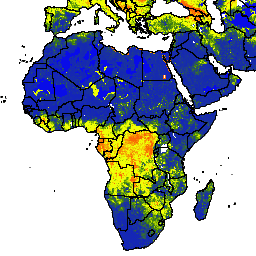
NASA-USDA 拡張版 SMAP 世界の土壌水分データは、地球全体の土壌水分情報を 10 km の空間解像度で提供します。このデータセットには、地表、地表下、土壌水分(mm)、土壌水分プロファイル(%)、地表と地表下の土壌水分異常(-)が含まれています。
このデータセットは、衛星から得られた Soil Moisture Active Passive(SMAP)レベル 3 の土壌水分観測データを、1 次元アンサンブル カルマン フィルタ(EnKF)データ同化アプローチを使用して、修正された 2 層の Palmer モデルに統合することで生成されます。土壌水分量の異常は、対象日の気候学から計算されました。気候学は、SMAP 衛星観測の完全なデータ記録と 31 日間の中心移動ウィンドウ アプローチに基づいて推定されました。SMAP 土壌水分観測の同化は、特に降水量のデータ品質が低い、世界の計測が不十分な地域で、モデルベースの土壌水分予測の改善に役立ちます。
このデータセットは、NASA の Goddard Space Flight Center の Hydrological Science Laboratory が、USDA Foreign Agricultural Services および USDA Hydrology and Remote Sensing Lab と協力して開発したものです。
バンド
バンド
ピクセルサイズ: 10,000 メートル(すべてのバンド)
| 名前 | 単位 | 最小 | 最大 | ピクセルサイズ | 説明 |
|---|---|---|---|---|---|
ssm |
mm | 0* | 25.39* | 10,000 メートル | 地表の土壌水分 |
susm |
mm | 0* | 274.6* | 10,000 メートル | 地表下の土壌水分 |
smp |
分数 | 0* | 1* | 10,000 メートル | 土壌水分プロファイル |
ssma |
無次元 | -4* | 4* | 10,000 メートル | 地表土壌水分異常 |
susma |
無次元 | -4* | 4* | 10,000 メートル | 地表下の土壌水分異常 |
利用規約
利用規約
このデータセットはパブリック ドメインにあり、使用と配布に制限はありません。詳しくは、NASA の地球科学データと情報に関するポリシーをご覧ください。
引用
Sazib, N.、J. D. Bolten、I. E. Mladenova。2021 年。NASA の Soil Moisture Active Passive を活用したオーストラリアとカリフォルニアにおける火災の発生しやすさと潜在的な影響の評価。IEEE Journal of Selected Topics in Applied Earth Observations and Remote Sensing, 15: 779-787. doi:10.1109/jstars.2021.3136756
Mladenova, I.E.、Bolten, J.D.、Crow, W.、Sazib, N. and Reynolds, C., 2020 年。SMAP 土壌水分抽出をグローバル土壌水収支モデルに同化させることによる農業干ばつモニタリング。前面。Big Data、3(10)。 doi:10.3389/fdata.2020.00010
Sazib, N.、J. D. Bolten、I. E. Mladenova。2021 年。NASA の Soil Moisture Active Passive を活用したオーストラリアとカリフォルニアにおける火災の発生しやすさと潜在的な影響の評価。IEEE Journal of Selected Topics in Applied Earth Observations and Remote Sensing, 15: 779-787. doi:10.1109/jstars.2021.3136756
Mladenova, I.E.、Bolten, J.D.、Crow, W.T.、Sazib, N.、Cosh, M.H.、Tucker, C.J.、Reynolds, C.、2019 年。全球の農業干ばつモニタリングにおける SMAP の運用アプリケーションの評価。IEEE Journal of Selected Topics in Applied Earth Observations and Remote Sensing、12(9): 3387-3397。 doi:10.1109/JSTARS.2019.2923555
Sazib, N.、Mladenova, I.、& Bolten, J. (2020 年)。地球観測データを使用したアフリカの農業に対する ENSO の影響の評価。Frontiers in Sustainable Food Systems、4、188。 doi:10.3389/fsufs.2020.509914 Google Scholar
Sazib, N.、Mladenova, I.、Bolten, J.、2018 年。世界中の土壌水分データを使用して干ばつを評価するために Google Earth Engine を活用します。Remote sensing, 10(8): 1265. doi:10.3390/rs10081265
Bolten, J.、W.T. Crow、X. Zhan、T.J. Jackson、C.A. Reynolds(2010 年)。Evaluating the Utility of Remotely Sensed Soil Moisture Retrievals for Operational Agricultural Drought Monitoring(運用上の農業干ばつモニタリングのためのリモート センシングによる土壌水分量推定の有用性の評価)、IEEE Transactions on Geoscience and Remote Sensing、3(1): 57-66。 doi:10.1109/JSTARS.2009.2037163 Google Scholar
Bolten, J., and W. T. Crow(2012 年)。リモート センシングされた地表土壌水分を使用した準地球規模の植生状態の予測の改善、Geophysical Research Letters、39: (L19406)。[doi:10.1029/2012GL053470][https://doi.org/10.1029/2012GL053470) Google Scholar
Entekhabi, D, Njoku, EG, O'Neill, PE, Kellogg, KH, Crow, WT, Edelstein, WN, Entin, JK, Goodman, SD, Jackson, TJ, Johnson, J, Kimball, J, Piepmeier, JR, Koster, RD, Martin, N, McDonald, KC, Moghaddam, M, Moran, S, Reichle, R, Shi, JC, Spencer, MW, Thurman, SW, Tsang, L & Van Zyl, J(2010 年)。The soil moisture active passive (SMAP) mission, Proceedings of the IEEE, 98(5): 704-716. doi:10.1109/JPROC.2010.2043918
I. E. Mladenova、J.D. Bolten、W.T. Crow、M.C. Anderson、C.R. Hain、D.M. Johnson、R. Mueller(2017 年)。米国におけるトウモロコシと大豆の収量を推定するための土壌水分、蒸発ストレス、植生指数の相互比較IEEE Journal of Selected Topics in Applied Earth Observations and Remote Sensing、10(4): 1328-1343。 doi:10.1109/JSTARS.2016.2639338
O'Neill, P. E., S. Chan, E. G. Njoku, T. Jackson、R. Bindlish(2016 年)。SMAP L3 Radiometer Global Daily 36 km EASE-Grid Soil Moisture, Version 4。Boulder, Colorado USA. NASA National Snow and Ice Data Center Distributed Active Archive Center.doi:10.5067/ZX7YX2Y2LHEB
DOI
- https://doi.org/10.1029/2012GL053470
- https://doi.org/10.1109/JPROC.2010.2043918
- https://doi.org/10.1109/JSTARS.2009.2037163
- https://doi.org/10.1109/JSTARS.2016.2639338
- https://doi.org/10.1109/JSTARS.2019.2923555
- https://doi.org/10.1109/jstars.2021.3136756
- https://doi.org/10.3389/fsufs.2020.509914
- https://doi.org/10.3390/rs10081265
- https://doi.org/10.5067/ZX7YX2Y2LHEB
Earth Engine で探索する
コードエディタ(JavaScript)
var dataset = ee.ImageCollection('NASA_USDA/HSL/SMAP10KM_soil_moisture')
                  .filter(ee.Filter.date('2017-04-01', '2017-04-30'));
var soilMoisture = dataset.select('ssm');
var soilMoistureVis = {
  min: 0.0,
  max: 28.0,
  palette: ['0300ff', '418504', 'efff07', 'efff07', 'ff0303'],
};
Map.setCenter(-6.746, 46.529, 2);
Map.addLayer(soilMoisture, soilMoistureVis, 'Soil Moisture');
import ee
import geemap.core as geemap
Colab(Python)
dataset = ee.ImageCollection('NASA_USDA/HSL/SMAP10KM_soil_moisture').filter(
    ee.Filter.date('2017-04-01', '2017-04-30')
)

soil_moisture = dataset.select('ssm')

soil_moisture_vis = {
    'min': 0.0,
    'max': 28.0,
    'palette': ['0300ff', '418504', 'efff07', 'efff07', 'ff0303'],
}

m = geemap.Map()
m.set_center(-6.746, 46.529, 2)
m.add_layer(soil_moisture, soil_moisture_vis, 'Soil Moisture')
m