- Disponibilité de l'ensemble de données
- 2015-04-02T12:00:00Z–2022-08-02T12:00:00Z
- Producteur de l'ensemble de données
- NASA GSFC
- Cadence
- 3 jours
- Tags
Description
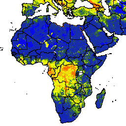
Les données mondiales améliorées sur l'humidité du sol SMAP de la NASA et de l'USDA fournissent des informations sur l'humidité du sol à l'échelle mondiale, avec une résolution spatiale de 10 km. Cet ensemble de données inclut les éléments suivants : surface, sous-surface, humidité du sol (mm), profil d'humidité du sol (%), anomalies d'humidité du sol en surface et en sous-surface (-).
L'ensemble de données est généré en intégrant les observations de l'humidité du sol active et passive (SMAP, Soil Moisture Active Passive) de niveau 3 dérivées par satellite dans le modèle Palmer modifié à deux couches à l'aide d'une approche d'assimilation de données de filtre Kalman d'ensemble (EnKF, Ensemble Kalman Filter) en 1D. Les anomalies d'humidité du sol ont été calculées à partir de la climatologie du jour concerné. La climatologie a été estimée sur la base de l'ensemble des données d'observation du satellite SMAP et de l'approche de la fenêtre mobile centrée sur 31 jours. L'assimilation des observations de l'humidité du sol SMAP permet d'améliorer les prédictions de l'humidité du sol basées sur des modèles, en particulier dans les régions du monde mal instrumentées qui manquent de données de précipitations de bonne qualité.
Cet ensemble de données a été développé par le laboratoire des sciences hydrologiques du centre de vol spatial Goddard de la NASA en coopération avec les services agricoles étrangers de l'USDA et le laboratoire d'hydrologie et de télédétection de l'USDA.
Bandes
Bandes de fréquences
Taille des pixels : 10 000 mètres (toutes les bandes)
| Nom | Unités | Min | Max | Taille des pixels | Description |
|---|---|---|---|---|---|
ssm |
mm | 0* | 25,39* | 10 000 mètres | Humidité de la surface du sol |
susm |
mm | 0* | 274,6* | 10 000 mètres | Humidité du sol en subsurface |
smp |
Fraction | 0* | 1* | 10 000 mètres | Profil d'humidité du sol |
ssma |
Sans dimension | -4* | 4* | 10 000 mètres | Anomalie d'humidité du sol en surface |
susma |
Sans dimension | -4* | 4* | 10 000 mètres | Anomalie d'humidité du sol en subsurface |
Conditions d'utilisation
Conditions d'utilisation
Cet ensemble de données appartient au domaine public et peut être utilisé ou diffusé sans aucune restriction. Pour en savoir plus, consultez le Règlement de la NASA sur les données et les informations scientifiques sur la Terre.
Citations
Sazib, N., J. D. Bolten, et I. E. Mladenova. 2021. Utilisation de la mission NASA Soil Moisture Active Passive pour évaluer la sensibilité au feu et les impacts potentiels en Australie et en Californie. IEEE Journal of Selected Topics in Applied Earth Observations and Remote Sensing, 15: 779-787. doi:10.1109/jstars.2021.3136756
Mladenova, I.E., Bolten, J.D., Crow, W., Sazib, N. and Reynolds, C., 2020. Surveillance de la sécheresse agricole par assimilation des données de récupération de l'humidité du sol SMAP dans un modèle global de bilan hydrique du sol. Avant. Big Data, 3(10). doi:10.3389/fdata.2020.00010
Sazib, N., J. D. Bolten et I. E. Mladenova. 2021. Utilisation de la mission NASA Soil Moisture Active Passive pour évaluer la sensibilité au feu et les impacts potentiels en Australie et en Californie. IEEE Journal of Selected Topics in Applied Earth Observations and Remote Sensing, 15: 779-787. doi:10.1109/jstars.2021.3136756
Mladenova, I.E., Bolten, J.D., Crow, W.T., Sazib, N., Cosh, M.H., Tucker, C.J. et Reynolds, C., 2019. Évaluation de l'application opérationnelle de SMAP pour la surveillance mondiale de la sécheresse agricole. IEEE Journal of Selected Topics in Applied Earth Observations and Remote Sensing, 12(9): 3387-3397. doi:10.1109/JSTARS.2019.2923555
Sazib, N., Mladenova, I., & Bolten, J. (2020). Évaluation de l'impact d'ENSO sur l'agriculture en Afrique à l'aide de données d'observation de la Terre. Frontiers in Sustainable Food Systems, 4, 188. doi:10.3389/fsufs.2020.509914 Google Scholar
Sazib, N., Mladenova, I. et Bolten, J., 2018. Utiliser Google Earth Engine pour évaluer la sécheresse à l'aide de données mondiales sur l'humidité du sol. Remote sensing, 10(8): 1265. doi:10.3390/rs10081265
Bolten, J., W.T. Crow, X. Zhan, T.J. Jackson et C.A. Reynolds (2010). Evaluating the Utility of Remotely Sensed Soil Moisture Retrievals for Operational Agricultural Drought Monitoring, IEEE Transactions on Geoscience and Remote Sensing, 3(1): 57-66. doi:10.1109/JSTARS.2009.2037163 Google Scholar
Bolten, J. et W. T. Crow (2012). Amélioration de la prédiction des conditions de végétation quasi mondiales à l'aide de l'humidité du sol en surface détectée à distance, Geophysical Research Letters, 39 : (L19406). [doi:10.1029/2012GL053470][https://doi.org/10.1029/2012GL053470) Google Scholar
Entekhabi, D, Njoku, EG, O'Neill, PE, Kellogg, KH, Crow, WT, Edelstein, WN, Entin, JK, Goodman, SD, Jackson, TJ, Johnson, J, Kimball, J, Piepmeier, JR, Koster, RD, Martin, N, McDonald, KC, Moghaddam, M, Moran, S, Reichle, R, Shi, JC, Spencer, MW, Thurman, SW, Tsang, L & Van Zyl, J (2010). The soil moisture active passive (SMAP) mission, Proceedings of the IEEE, 98(5): 704-716. doi:10.1109/JPROC.2010.2043918
I. E. Mladenova, J.D. Bolten, W.T. Crow, M.C. Anderson, C.R. Hain, D.M. Johnson, R. Mueller (2017). Intercomparison of Soil Moisture, Evaporative Stress, and Vegetation Indices for Estimating Corn and Soybean Yields Over the U.S., IEEE Journal of Selected Topics in Applied Earth Observations and Remote Sensing, 10(4): 1328-1343. doi:10.1109/JSTARS.2016.2639338
O'Neill, P. E., S. Chan, E. G. Njoku, T. Jackson et R. Bindlish (2016). SMAP L3 Radiometer Global Daily 36 km EASE-Grid Soil Moisture, Version 4. Boulder, Colorado, États-Unis. NASA National Snow and Ice Data Center Distributed Active Archive Center.doi:10.5067/ZX7YX2Y2LHEB
DOI
- https://doi.org/10.1029/2012GL053470
- https://doi.org/10.1109/JPROC.2010.2043918
- https://doi.org/10.1109/JSTARS.2009.2037163
- https://doi.org/10.1109/JSTARS.2016.2639338
- https://doi.org/10.1109/JSTARS.2019.2923555
- https://doi.org/10.1109/jstars.2021.3136756
- https://doi.org/10.3389/fsufs.2020.509914
- https://doi.org/10.3390/rs10081265
- https://doi.org/10.5067/ZX7YX2Y2LHEB
Explorer avec Earth Engine
Éditeur de code (JavaScript)
var dataset = ee.ImageCollection('NASA_USDA/HSL/SMAP10KM_soil_moisture')
                  .filter(ee.Filter.date('2017-04-01', '2017-04-30'));
var soilMoisture = dataset.select('ssm');
var soilMoistureVis = {
  min: 0.0,
  max: 28.0,
  palette: ['0300ff', '418504', 'efff07', 'efff07', 'ff0303'],
};
Map.setCenter(-6.746, 46.529, 2);
Map.addLayer(soilMoisture, soilMoistureVis, 'Soil Moisture');
import ee
import geemap.core as geemap
Colab (Python)
dataset = ee.ImageCollection('NASA_USDA/HSL/SMAP10KM_soil_moisture').filter(
    ee.Filter.date('2017-04-01', '2017-04-30')
)

soil_moisture = dataset.select('ssm')

soil_moisture_vis = {
    'min': 0.0,
    'max': 28.0,
    'palette': ['0300ff', '418504', 'efff07', 'efff07', 'ff0303'],
}

m = geemap.Map()
m.set_center(-6.746, 46.529, 2)
m.add_layer(soil_moisture, soil_moisture_vis, 'Soil Moisture')
m