Page Summary
-
The SMAP Level-4 (L4) Soil Moisture product provides global 3-hourly data on surface and root-zone soil moisture.
-
This dataset also includes research products such as soil temperature, evapotranspiration, and net radiation.
-
The data is available from March 31, 2015, to October 14, 2025.
-
The dataset is in the public domain and can be used without restriction.
-
The data is provided by Google and NSIDC.
- Dataset Availability
- 2015-03-31T00:00:00Z–2026-06-21T22:30:00Z
- Dataset Producer
- Google and NSIDC
- Cadence
- 3 Hours
- Tags
Description
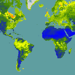
The SMAP Level-4 (L4) Soil Moisture product includes surface soil moisture (0-5 cm vertical average), root-zone soil moisture (0-100 cm vertical average), and additional research products (not validated), including surface meteorological forcing variables, soil temperature, evapotranspiration, and net radiation. This dataset, formally known as the SMAP L4 Global 3-hourly 9 km EASE-Grid Surface and Root Zone Soil Moisture Geophysical Data (SPL4SMGP), is considered the primary product of interest for most users of the SMAP Level-4 (L4) soil moisture data.
SMAP L4 provides uninterrupted soil moisture data. During outages of the SMAP instrument, SMAP L4 soil moisture is based on land model simulations alone, without the concomitant assimilation of SMAP brightness temperature observations. Significant SMAP instrument outages occurred between 19 June and 23 July 2019 and between 6 August and 20 September 2022.
SMAP L-band brightness temperature data from descending and ascending half-orbit satellite passes (approximately 6:00 a.m. and 6:00 p.m. local solar time, respectively) are assimilated into a land surface model that is gridded using an Earth-fixed, global cylindrical 9 km Equal-Area Scalable Earth Grid, Version 2.0 (EASE-Grid 2.0) projection.
The SPL4SMGP product includes a series of 3-hourly time-averaged geophysical data fields from the assimilation system. SPL4SMGP data are transformed to geographic coordinates using GDAL libraries before the data are ingested into Google Earth Engine.
See the SMAP L4 Soil Moisture User Guide and references therein for additional documentation and algorithm details.
See basic and advanced tutorials to learn how to use SMAP data in Earth Engine.
Bands
Bands
Pixel size: 11000 meters (all bands)
| Name | Units | Min | Max | Pixel Size | Description |
|---|---|---|---|---|---|
sm_surface |
Volume fraction | 0 | 0.9 | 11000 meters | Top layer soil moisture (0-5 cm) |
sm_rootzone |
Volume fraction | 0 | 0.9 | 11000 meters | Root zone soil moisture (0-100 cm) |
sm_profile |
Volume fraction | 0 | 0.9 | 11000 meters | Total profile soil moisture (0 cm to model bedrock depth). |
sm_surface_wetness |
0 | 1 | 11000 meters | Top layer soil wetness (0-5 cm; wetness units). Soil wetness units (dimensionless) vary between 0 and 1, indicating relative saturation between completely dry conditions and completely saturated conditions, respectively. |
|
sm_rootzone_wetness |
0 | 1 | 11000 meters | Root zone soil wetness (0-100 cm; wetness units). Soil wetness units (dimensionless) vary between 0 and 1, indicating relative saturation between completely dry conditions and completely saturated conditions, respectively. |
|
sm_profile_wetness |
0 | 1 | 11000 meters | Total profile soil wetness (0 cm to model bedrock depth; wetness units). Soil wetness units (dimensionless) vary between 0 and 1, indicating relative saturation between completely dry conditions and completely saturated conditions, respectively. |
|
surface_temp |
K | 180 | 350 | 11000 meters | Mean land surface temperature (including snow-covered land area). Excluding areas of open water and permanent ice |
soil_temp_layer1 |
K | 210 | 350 | 11000 meters | Soil temperature in layer 1 of soil heat diffusion model |
soil_temp_layer2 |
K | 210 | 330 | 11000 meters | Soil temperature in layer 2 of soil heat diffusion model |
soil_temp_layer3 |
K | 215 | 325 | 11000 meters | Soil temperature in layer 3 of soil heat diffusion model |
soil_temp_layer4 |
K | 220 | 325 | 11000 meters | Soil temperature in layer 4 of soil heat diffusion model |
soil_temp_layer5 |
K | 225 | 325 | 11000 meters | Soil temperature in layer 5 of soil heat diffusion model |
soil_temp_layer6 |
K | 230 | 320 | 11000 meters | Soil temperature in layer 6 of soil heat diffusion model |
snow_mass |
kg/m^2 | 0 | 10000 | 11000 meters | Average snow mass (or snow water equivalent) over land fraction of grid cell |
snow_depth |
m | 0 | 50 | 11000 meters | Snow depth within snow-covered land fraction of grid cell |
land_evapotranspiration_flux |
kg/m^2/s | -0.001 | 0.001 | 11000 meters | Evapotranspiration from land |
overland_runoff_flux |
kg/m^2/s | 0 | 0.05 | 11000 meters | Overland (surface) runoff (including throughflow) |
baseflow_flux |
kg/m^2/s | 0 | 0.01 | 11000 meters | Baseflow |
snow_melt_flux |
kg/m^2/s | 0 | 0.05 | 11000 meters | Snowmelt |
soil_water_infiltration_flux |
kg/m^2/s | 0 | 0.05 | 11000 meters | Soil water infiltration rate |
land_fraction_saturated |
0 | 1 | 11000 meters | Fractional land area that is saturated and snow-free |
|
land_fraction_unsaturated |
0 | 1 | 11000 meters | Fractional land area that is unsaturated (but non-wilting) and snow-free |
|
land_fraction_wilting |
0 | 1 | 11000 meters | Fractional land area that is wilting and snow-free |
|
land_fraction_snow_covered |
0 | 1 | 11000 meters | Fractional land area that is snowcovered |
|
heat_flux_sensible |
W/m^2 | -2500 | 3000 | 11000 meters | Sensible heat flux from land |
heat_flux_latent |
W/m^2 | -2500 | 3000 | 11000 meters | Latent heat flux from land |
heat_flux_ground |
W/m^2 | -1000 | 1000 | 11000 meters | Downward ground heat flux into layer 1 of soil heat diffusion model |
net_downward_shortwave_flux |
W/m^2 | 0 | 1365 | 11000 meters | Net downward shortwave flux over land |
net_downward_longwave_flux |
W/m^2 | -1000 | 200 | 11000 meters | Net downward longwave flux over land |
radiation_shortwave_downward_flux |
W/m^2 | 0 | 1500 | 11000 meters | Downward shortwave flux incident on the surface |
radiation_longwave_absorbed_flux |
W/m^2 | 35 | 800 | 11000 meters | Absorbed (downward) longwave radiation at the surface |
precipitation_total_surface_flux |
kg m^-2 s^-2 | 0 | 0.05 | 11000 meters | Total surface precipitation (incl. snow fall) |
snowfall_surface_flux |
kg m^-2 s^-2 | 0 | 0.05 | 11000 meters | Surface snow fall |
surface_pressure |
K | 40000 | 110000 | 11000 meters | Mean land surface temperature (incl. snow-covered land area) |
height_lowatmmodlay |
m | 40 | 80 | 11000 meters | Center height of lowest atmospheric model layer |
temp_lowatmmodlay |
K | 180 | 350 | 11000 meters | Air temperature at center height of lowest atmospheric model layer |
specific_humidity_lowatmmodlay |
Mass fraction | 0 | 0.4 | 11000 meters | Air specific humidity at center height of lowest atmospheric model layer |
windspeed_lowatmmodlay |
m/s | -60 | 60 | 11000 meters | Surface wind speed at center height of lowest atmospheric model layer |
vegetation_greenness_fraction |
0 | 1 | 11000 meters | Vegetation "greenness" or fraction of transpiring leaves averaged over the land area* of the grid cell. |
|
leaf_area_index |
Area fraction | 0 | 10 | 11000 meters | Vegetation leaf area index |
sm_rootzone_pctl |
% | 0 | 100 | 11000 meters | Root zone soil moisture (0-100 cm; percentile units) |
sm_profile_pctl |
% | 0 | 100 | 11000 meters | Total profile soil moisture (0 cm to model bedrock depth; percentile units) |
depth_to_water_table_from_surface_in_peat |
m | -5 | 0.15 | 11000 meters | Depth to water table from mean surface elevation in peatlands (positive above ground) |
free_surface_water_on_peat_flux |
kg/m^2/s | -0.001 | 0.001 | 11000 meters | Change in free surface water storage on peatlands |
mwrtm_vegopacity |
0 | 2.5 | 11000 meters | Microwave radiative transfer model: Vegetation opacity. |
|
sm_surface_anomaly |
11000 meters | Experimental. Difference of the 30-day average of 'sm_surface', centered on asset date, relative to the same 30-day period averaged across years from 2015 to present, excluding asset year. See this script for anomaly computations. |
Terms of Use
Terms of Use
This dataset is in the public domain and is available without restriction on use and distribution. See NASA's Earth Science Data & Information Policy for additional information.
Citations
Reichle, R., De Lannoy, G., Koster, R. D., Crow, W. T., Kimball, J. S., Liu, Q. & Bechtold, M. (2025). SMAP L4 Global 3-hourly 9 km EASE-Grid Surface and Root Zone Soil Moisture Geophysical Data. (SPL4SMGP, Version 8). [Data Set]. Boulder, Colorado USA. NASA National Snow and Ice Data Center Distributed Active Archive Center. doi:10.5067/T5RUATAQREF8
DOIs
Explore with Earth Engine
Code Editor (JavaScript)
var dataset = ee.ImageCollection('NASA/SMAP/SPL4SMGP/008').first();

var smSurface = dataset.select('sm_surface');
var smSurfaceVis = {
  min: 0.0,
  max: 0.9,
  palette: ['0300ff', '418504', 'efff07', 'efff07', 'ff0303'],
};
Map.setCenter(-6.746, 46.529, 2);
Map.addLayer(smSurface, smSurfaceVis, 'SM Surface');