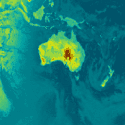
- Disponibilidade de conjuntos de dados
- 1980-01-01T00:00:00Z–2025-12-01T23:00:00Z
- Provedor de conjunto de dados
- NASA/MERRA
- Cadência
- 1 hora
- Tags
Descrição
M2T1NXRAD (ou tavg1_2d_rad_Nx) é uma coleta de dados com média horária na análise retrospectiva da era moderna para pesquisa e aplicativos, versão 2 (MERRA-2). Essa coleção consiste em diagnósticos de radiação, como albedo da superfície, fração da área de nuvem, espessura óptica na nuvem, fluxo de ondas curtas incidentes na superfície (ou seja, radiação solar), fluxo de ondas curtas descendentes líquidas na superfície e fluxo de ondas longas ascendentes no TOA (parte superior da atmosfera), ou seja, radiação de ondas longas (OLR) no TOA. O campo de dados recebe um carimbo de data/hora com o horário central de uma hora a partir das 00h30 UTC, por exemplo: 00:30, 01:30, ... , 23:30 UTC.
O MERRA-2 é a versão mais recente da reanálise atmosférica global para a era dos satélites, produzida pelo Global Modeling and Assimilation Office (GMAO) da NASA usando o Goddard Earth Observing System Model (GEOS) versão 5.12.4. O conjunto de dados abrange o período de 1980 até o presente, com uma latência de aproximadamente três semanas após o fim de um mês.
Bandas
Tamanho do pixel
69.375 metros
Tamanho do pixel Y
55.000 metros
Bandas
| Nome | Unidades | Mín. | Máx. | Tamanho do pixel | Descrição |
|---|---|---|---|---|---|
ALBEDO |
0,01* | 0,898471* | metros | Albedo da plataforma |
|
ALBNIRDF |
0,017455* | 0,820016* | metros | Albedo da superfície para infravermelho próximo difuso |
|
ALBNIRDR |
0,018709* | 0,82001* | metros | Albedo da superfície para feixe de infravermelho próximo |
|
ALBVISDF |
0,016788* | 0,959771* | metros | Albedo da superfície para difusão visível |
|
ALBVISDR |
0,01853* | 0,959762* | metros | Albedo da superfície para feixe visível |
|
CLDHGH |
0* | 0,999236* | metros | Fração da área de nuvem para nuvens altas |
|
CLDLOW |
0* | 0,999997* | metros | Fração da área de nuvem para nuvens baixas |
|
CLDMID |
0* | 0,998779* | metros | Fração da área de nuvem para nuvens médias |
|
CLDTOT |
0* | 1* | metros | Fração da área total de nuvem |
|
EMIS |
0,943074* | 0,999993* | metros | Emissividade da superfície |
|
LWGABCLRCLN |
W/m² | 41,1408* | 458.523* | metros | A superfície absorveu radiação de ondas longas considerando céu limpo e sem aerossol |
LWGABCLR |
W/m² | 41,1414* | 465.929* | metros | A superfície absorveu radiação de ondas longas, considerando um céu sem nuvens |
LWGAB |
W/m² | 41,1446* | 482.398* | metros | Radiação de ondas longas absorvida pela superfície |
LWGEM |
W/m² | 67,5297* | 630,29* | metros | Fluxo de ondas longas emitido da superfície |
LWGNTCLRCLN |
W/m² | -248.748* | 61,0736* | metros | Fluxo de onda longa descendente da rede da superfície, considerando céu claro e sem aerossol |
LWGNTCLR |
W/m² | -248.653* | 62,2794* | metros | Fluxo de ondas longas descendentes da rede de superfície considerando céu claro |
LWGNT |
W/m² | -268.862* | 77,255* | metros | Fluxo de onda longa descendente da rede de superfície |
LWTUPCLRCLN |
W/m² | 80,6768* | 372.229* | metros | Fluxo de ondas longas de ressurgência no TOA, considerando céu claro e sem aerossol |
LWTUPCLR |
W/m² | 80,6768* | 372.229* | metros | Fluxo de ondas longas de ressurgência no TOA, considerando céu claro |
LWTUP |
W/m² | 80,6506* | 370.868* | metros | Fluxo de ondas longas ascendentes na TOA |
SWGDNCLR |
W/m² | -0,008217* | 1155,5* | metros | Fluxo de ondas curtas incidentes na superfície, considerando céu limpo |
SWGDN |
W/m² | 0* | 1127,49* | metros | Fluxo de ondas curtas incidentes na superfície |
SWGNTCLN |
W/m² | 0* | 1088,42* | metros | Fluxo de ondas curtas descendente líquido da superfície, sem considerar aerossóis |
SWGNTCLRCLN |
W/m² | -3,2e-05* | 1088,42* | metros | Fluxo de ondas curtas descendente líquido da superfície, assumindo céu claro e sem aerossol |
SWGNTCLR |
W/m² | -0,001333* | 1083,95* | metros | Fluxo de ondas curtas descendentes da rede de superfície considerando céu limpo |
SWGNT |
W/m² | 0* | 1083,95* | metros | Fluxo de ondas curtas descendente líquido na superfície |
SWTDN |
W/m² | 0* | 1404,28* | metros | Fluxo de ondas curtas de TOA |
SWTNTCLN |
W/m² | 0* | 1315,89* | metros | Fluxo de ondas curtas descendente líquido no TOA sem considerar aerossóis |
SWTNTCLRCLN |
W/m² | 0* | 1317,5* | metros | Fluxo de ondas curtas descendente líquido no TOA, assumindo céu claro e sem aerossol |
SWTNTCLR |
W/m² | 0* | 1316,5* | metros | Fluxo de ondas curtas descendentes da TOA, considerando céu limpo |
SWTNT |
W/m² | 0* | 1313,33* | metros | Fluxo de ondas curtas descendente líquido da TOA |
TAUHGH |
0* | 142.188* | metros | Espessura óptica na nuvem de nuvens altas(exportação) |
|
TAULOW |
0* | 318.218* | metros | Na espessura óptica de nuvens baixas |
|
TAUMID |
0* | 252.995* | metros | Espessura óptica das nuvens médias |
|
TAUTOT |
0* | 348.125* | metros | Na espessura óptica da nuvem de todas as nuvens |
|
TS |
K | 185,73* | 328.864* | metros | Temperatura da pele na superfície |
Termos de Uso
Termos de Uso
A NASA promove o compartilhamento total e aberto de todos os dados com as comunidades de pesquisa e aplicativos, a indústria privada, a academia e o público em geral.
Descobrir com o Earth Engine
Editor de código (JavaScript)
var dataset = ee.ImageCollection('NASA/GSFC/MERRA/rad/2')
                  .filter(ee.Filter.date('2022-02-01', '2022-02-02')).first();
var surface_albedo = dataset.select('ALBEDO');
var saVis = {
  min: -0.428147,
  max: 0.833350,
  palette: ['001137', '01abab', 'e7eb05', '620500']
};
Map.setCenter(-95, 39, 2);
Map.addLayer(surface_albedo, saVis, 'Surface albedo');