- Disponibilidade do conjunto de dados
- 2002-12-31T00:00:00Z–2016-12-10T00:00:00Z
- Produtor do conjunto de dados
- NASA Jet Propulsion Laboratory
- Tags
Descrição
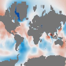
As grades de massa mensais do GRACE Tellus fornecem anomalias gravitacionais mensais em relação a uma linha de base média de 2004 a 2010. Os dados contidos nesse conjunto são unidades de "espessura de água equivalente", que representam os desvios de massa em termos de extensão vertical de água em centímetros. Consulte a visão geral das grades de massa mensais do provedor para mais detalhes.
Esse conjunto de dados é uma versão filtrada do conjunto de dados do oceano GRACE Tellus (GRCTellus). As grades de pressão de fundo (OBP, na sigla em inglês) "EOFR" são obtidas projetando os dados do produto de grades oceânicas GRC regulares nas funções ortogonais empíricas (EOFs, na sigla em inglês) do modelo oceânico para circulação e marés (OMCT, na sigla em inglês). Isso filtra efetivamente os sinais nos dados do GRACE que são inconsistentes com a física e as variações de OBP no modelo oceânico OMCT.
Os campos de OBP reconstruídos filtrados por EOFR concordam melhor com a altura da superfície do mar altimétrica de radar, reduzem o vazamento em torno de calotas polares e geleiras e reduzem o ruído nas latitudes médias, onde a variabilidade de OBP é menor. (Chambers e Willis, 2010)
Observação
- Os conjuntos de dados do oceano GRCTellus são otimizados para examinar a pressão do fundo do oceano regional, mas NÃO são destinados a serem espacialmente calculados para determinar a massa oceânica média global.
Bandas
Bandas
Tamanho do pixel: 111.320 metros (todas as bandas)
| Nome | Unidades | Mín. | Máx. | Tamanho do pixel | Descrição |
|---|---|---|---|---|---|
lwe_thickness_csr |
cm | -18,46* | 12,29* | 111.320 metros | Espessura equivalente de água líquida em centímetros calculada pelo CSR. |
lwe_thickness_gfz |
cm | -15,37* | 14,56* | 111.320 metros | Espessura equivalente de água líquida em centímetros calculada pelo GFZ. |
lwe_thickness_jpl |
cm | -16,59* | 11,7* | 111.320 metros | Espessura equivalente de água líquida em centímetros calculada pelo JPL. |
Propriedades da imagem
Propriedades da imagem
| Nome | Tipo | Descrição |
|---|---|---|
| CSR_END_TIME | DOUBLE | Data de término em milissegundos da solução de harmônicos esféricos do CSR. |
| CSR_START_TIME | DOUBLE | Data de início em milissegundos da solução de harmônicos esféricos do CSR. |
| GFZ_END_TIME | DOUBLE | Data de término em milissegundos da solução de harmônicos esféricos do GFZ. |
| GFZ_START_TIME | DOUBLE | Data de início em milissegundos da solução de harmônicos esféricos do GFZ. |
| JPL_END_TIME | DOUBLE | Data de término em milissegundos da solução de harmônicos esféricos do JPL. |
| JPL_START_TIME | DOUBLE | Data de início em milissegundos da solução de harmônicos esféricos do JPL. |
Termos de Uso
Termos de Uso
Todos os dados produzidos pela NASA da missão GRACE são disponibilizados sem custo financeiro para uso público. Ao usar qualquer um dos dados do GRCTellus, adicione um reconhecimento: "A terra do GRACE está disponível em https://grace.jpl.nasa.gov, com suporte do programa MEaSUREs da NASA" e cite as citações fornecidas.
Citações
D.P. Chambers. 2012. GRACE MONTHLY OCEAN MASS GRIDS NETCDF RELEASE 5.0. Ver. 5.0. PO.DAAC, CA, EUA. Conjunto de dados acessado em [YYYY-MM-DD] em doi:10.5067/TEOCN-0N005.
Chambers, D.P. e J.A. Bonin: Evaluation of Release 05 time-variable gravity coefficients over the ocean. Ocean Science 8, 859-868, 2012. doi:10.5194/os-8-859-2012.
Chambers D.P. e J. K. Willis: A Global Evaluation of Ocean Bottom Pressure from GRACE, OMCT, and Steric-Corrected Altimetry. J. of Oceanic and Atmosph. Technology, vol 27, pp 1395-1402, 2010.. doi:10.1175/2010JTECHO738.1
Identificadores DOI
Explore com o Earth Engine
Editor de código (JavaScript)
var dataset = ee.ImageCollection('NASA/GRACE/MASS_GRIDS/OCEAN_EOFR')
                  .filter(ee.Filter.date('2016-08-01', '2016-08-30'));
var equivalentWaterThicknessCsr = dataset.select('lwe_thickness_csr');
var equivalentWaterThicknessCsrVis = {
  min: -10.0,
  max: 10.0,
};
Map.setCenter(6.746, 46.529, 1);
Map.addLayer(
    equivalentWaterThicknessCsr, equivalentWaterThicknessCsrVis,
    'Equivalent Water Thickness CSR');