- Disponibilidade do conjunto de dados
- 2002-04-01T00:00:00Z–2017-01-07T00:00:00Z
- Produtor de conjunto de dados
- Laboratório de Propulsão a Jato da NASA
- Tags
Descrição
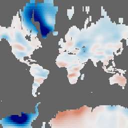
As grades de massa mensais do GRACE Tellus fornecem anomalias gravitacionais mensais em relação a um valor de referência médio de 2004 a 2010. Os dados contidos neste conjunto de dados são unidades de "Espessura equivalente de água", que representam os desvios de massa em termos de extensão vertical de água em centímetros. Consulte a Visão geral das grades mensais em massa do provedor para mais detalhes.
O conjunto de dados GRACE Tellus (GRCTellus) Monthly Mass Grids é produzido por três centros: CSR (U. Texas / Center for Space Research), GFZ (GeoForschungsZentrum Potsdam) e JPL (NASA Jet Propulsion Laboratory). Cada centro faz parte do sistema terrestre GRACE e gera dados de nível 2 (campos harmônicos esféricos) usados neste conjunto de dados. A saída inclui coeficientes harmônicos esféricos do campo gravitacional e dos campos de eliminação de aliasing usados para calculá-los. Como cada centro produz os coeficientes de forma independente, os resultados podem ser ligeiramente diferentes. Recomendamos que a maioria dos usuários use a média dos três conjuntos de dados. Consulte a página Escolher uma solução do provedor para mais detalhes.
Observação
Devido à amostragem e ao pós-processamento das observações do GRACE, as variações de massa da superfície em pequenas escalas espaciais tendem a ser atenuadas. Portanto, os usuários precisam multiplicar os dados terrestres do GRCTellus pela grade de escalonamento disponível em NASA/GRACE/MASS_GRIDS/LAND_AUX_2014.
As grades terrestres do GRCTellus processadas com base nos dados harmônicos esféricos de nível 2 não são adequadas para quantificar com precisão as mudanças na massa de gelo na Groenlândia ou na Antártica, nem em geleiras e calotas polares. Para essas áreas, recomendamos usar a solução de mascon do JPL, disponível como a seguinte coleção de imagens: NASA/GRACE/MASS_GRIDS/MASCON
Bandas
Bandas
Tamanho do pixel: 111.320 metros (todas as bandas)
| Nome | Unidades | Mín. | Máx. | Tamanho do pixel | Descrição |
|---|---|---|---|---|---|
lwe_thickness_csr |
cm | -139,2* | 74,88* | 111.320 metros | Espessura equivalente de água líquida em centímetros calculada pelo CSR. |
lwe_thickness_gfz |
cm | -145,45* | 70,19* | 111.320 metros | Espessura equivalente de água líquida em centímetros calculada pela GFZ. |
lwe_thickness_jpl |
cm | -137,94* | 71,86* | 111.320 metros | Espessura equivalente de água líquida em centímetros calculada pelo JPL. |
Propriedades de imagens
Propriedades da imagem
| Nome | Tipo | Descrição |
|---|---|---|
| CSR_END_TIME | DOUBLE | Data de término em milissegundos da solução de harmônicos esféricos da CSR. |
| CSR_START_TIME | DOUBLE | Data de início em milissegundos da solução de harmônicos esféricos da CSR. |
| GFZ_END_TIME | DOUBLE | Data de término em milissegundos da solução de harmônicos esféricos da GFZ. |
| GFZ_START_TIME | DOUBLE | Data de início em milissegundos da solução de harmônicos esféricos da GFZ. |
| JPL_END_TIME | DOUBLE | Data de término em milissegundos da solução de harmônicos esféricos do JPL. |
| JPL_START_TIME | DOUBLE | Data de início em milissegundos da solução de harmônicos esféricos do JPL. |
Termos de Uso
Termos de Uso
Todos os dados produzidos pela NASA na missão GRACE estão disponíveis sem custo financeiro para uso público. Ao usar qualquer um dos dados do GRCTellus, adicione um reconhecimento: "As áreas terrestres do GRACE estão disponíveis em https://grace.jpl.nasa.gov, com suporte do Programa MEaSUREs da NASA" e cite as fontes fornecidas.
Citações
S.C. Swenson. 2012. GRACE monthly land water mass grids NETCDF RELEASE 5.0. Ver. 5.0. PO.DAAC, CA, EUA. Acesso ao conjunto de dados em [AAAA-MM-DD] em https://doi.org/10.5067/TELND-NC005.
Landerer F.W. e S. C. Swenson, Accuracy of scaled GRACE terrestrial water storage estimates. Water Resources Research, Vol 48, W04531, 11 PP, doi:10.1029/2011WR011453, 2012.
Swenson, S. C. e J. Wahr, Post-processing removal of correlated errors in GRACE data, Geophys. Res. Lett., 33, L08402, doi:10.1029/2005GL025285, 2006.
Identificadores DOI
Explore com o Earth Engine
Editor de código (JavaScript)
var dataset = ee.ImageCollection('NASA/GRACE/MASS_GRIDS/LAND')
                  .filter(ee.Filter.date('2016-08-01', '2016-08-30'));
var equivalentWaterThicknessCsr = dataset.select('lwe_thickness_csr');
var equivalentWaterThicknessCsrVis = {
  min: -25.0,
  max: 25.0,
};
Map.setCenter(6.746, 46.529, 2);
Map.addLayer(
    equivalentWaterThicknessCsr, equivalentWaterThicknessCsrVis,
    'Equivalent Water Thickness CSR');