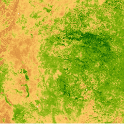
The Normalized Difference Vegetation Index is
generated from the Near-IR and Red bands of each scene as (NIR - Red) /
(NIR + Red), and ranges in value from -1.0 to 1.0. This product is generated from the MODIS/MYD09GA surface reflectance composites.
Bands
Bands
Pixel size: 463.313 meters (all bands)
Name
Min
Max
Pixel Size
Description
NDVI
-1*
1*
463.313 meters
Normalized Difference Vegetation Index
* estimated min or max value
Terms of Use
Terms of Use
MODIS data and products acquired through the LP DAAC have no restrictions on subsequent use, sale, or redistribution.
The Normalized Difference Vegetation Index is generated from the Near-IR and Red bands of each scene as (NIR - Red) / (NIR + Red), and ranges in value from -1.0 to 1.0. This product is generated from the MODIS/MYD09GA surface reflectance composites.
[[["Easy to understand","easyToUnderstand","thumb-up"],["Solved my problem","solvedMyProblem","thumb-up"],["Other","otherUp","thumb-up"]],[["Missing the information I need","missingTheInformationINeed","thumb-down"],["Too complicated / too many steps","tooComplicatedTooManySteps","thumb-down"],["Out of date","outOfDate","thumb-down"],["Samples / code issue","samplesCodeIssue","thumb-down"],["Other","otherDown","thumb-down"]],[],[],["This dataset, MODIS/MYD09GA_NDVI, provides the Normalized Difference Vegetation Index (NDVI) derived from MODIS surface reflectance composites. NDVI values range from -1.0 to 1.0, calculated as (NIR - Red) / (NIR + Red), with a daily cadence and 463.313-meter pixel size. It spans from 2002-07-04 to 2017-03-30. The data is freely available for use, sale, and redistribution. It has been superseded by MODIS/MYD09GA_006_NDVI. Earth Engine access registration is required.\n"]]