Page Summary
-
The Normalized Difference Water Index (NDWI) measures liquid water content in vegetation canopies and is derived from near-infrared and infrared bands.
-
This dataset provides NDWI values ranging from -1.0 to 1.0 and is generated from MODIS/006/MYD09GA surface reflectance composites.
-
The data is available daily from 2002-07-04 to 2023-02-25 and has no restrictions on use, sale, or redistribution.
- Dataset Availability
- 2002-07-04T00:00:00Z–2023-02-25T00:00:00Z
- Dataset Producer
- Cadence
- 1 Day
- Tags
Description
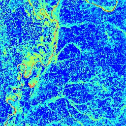
The Normalized Difference Water Index (NDWI) is sensitive to changes in liquid water content of vegetation canopies. It is derived from the Near-IR band and a second IR band, ≈1.24μm when available and the nearest available IR band otherwise. It ranges in value from -1.0 to 1.0. See Gao (1996) for details. This product is generated from the MODIS/006/MYD09GA surface reflectance composites.
Bands
Bands
Pixel size: 463.313 meters (all bands)
| Name | Pixel Size | Description |
|---|---|---|
NDWI |
463.313 meters | Normalized Difference Water Index |
Terms of Use
Terms of Use
MODIS data and products acquired through the LP DAAC have no restrictions on subsequent use, sale, or redistribution.
Explore with Earth Engine
Code Editor (JavaScript)
var dataset = ee.ImageCollection('MODIS/MYD09GA_006_NDWI')
                  .filter(ee.Filter.date('2018-04-01', '2018-06-01'));
var colorized = dataset.select('NDWI');
var colorizedVis = {
  min: 0.0,
  max: 1.0,
  palette: ['0000ff', '00ffff', 'ffff00', 'ff0000', 'ffffff'],
};
Map.setCenter(-7.03125, 31.0529339857, 2);
Map.addLayer(colorized, colorizedVis, 'Colorized');