- Veri Kümesi Kullanılabilirliği
- 1987-01-01T00:00:00Z–2017-01-01T00:00:00Z
- Veri Kümesi Üreticisi
- Dai Yamazaki (Tokyo Üniversitesi)
- Etiketler
Açıklama
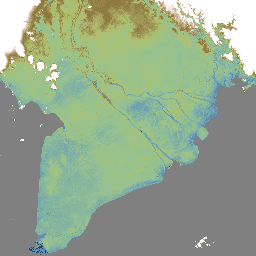
MERIT DEM, mevcut DEM'lerdeki (NASA SRTM3 DEM, JAXA AW3D DEM, Viewfinder Panoramas DEM) büyük hata bileşenleri ortadan kaldırılarak üretilmiş, 3 yay saniyesi çözünürlüğe (~ekvatorda 90 m) sahip yüksek doğruluklu küresel bir DEM'dir.
MERIT DEM, mutlak önyargıyı, şerit gürültüsünü, benek gürültüsünü ve ağaç yüksekliği önyargısını birden fazla uydu veri kümesi ve filtreleme tekniği kullanarak ayırır. Hata kaldırıldıktan sonra, 2 metre veya daha iyi dikey doğrulukla haritalandırılan kara alanları% 39'dan %58'e yükseldi. Yükseklik hatalarının topoğrafya değişkenliğinden daha büyük olduğu düz bölgelerde önemli iyileştirmeler yapıldı. Nehir ağları ve tepe-vadi yapıları gibi manzaralar net bir şekilde gösterildi.
"MERIT DEM, temel veri olarak aşağıdaki ürünler işlenerek geliştirilmiştir:
Yukarıdaki temel demografik bilgilere ek olarak şu ürünler ek veri olarak kullanıldı:
Bantlar
Bantlar
Piksel boyutu: 92,77 metre (tüm bantlar)
| Ad | Piksel Boyutu | Açıklama |
|---|---|---|
dem |
92,77 metre | EGM96 jeoid modeline göre referanslandırılmış, metre cinsinden rakım. |
Kullanım Şartları
Kullanım Şartları
MERIT DEM'i kullanmanız durumunda makaleye atıfta bulunmanız yeterlidir. Veri kümesinin ek işlenmesi/düzenlenmesi için yardım istediyseniz veya araştırma sonucunuz ürüne büyük ölçüde bağlıysa geliştirici, ortak yazarlık isteğinde bulunur.
MERIT DEM, Creative Commons "CC-BY-NC 4.0" veya Open Data Commons "Open Database License (ODbL 1.0)" kapsamında lisanslanmıştır. Çift lisansla, sizin için uygun bir lisans seçebilirsiniz.
Bu lisansların bir kopyasını görüntülemek için lütfen şu adresi ziyaret edin:
- CC-BY-NC 4.0 lisansı: Daha az kısıtlamayla ticari olmayan kullanım.
- ODbL 1.0 lisansı: Ticari kullanım uygundur ancak MERIT DEM'e dayalı türetilmiş veriler aynı ODbL lisansı kapsamında herkese açık hale getirilmelidir. Örneğin, MERIT DEM kullanarak sel tehlikesi haritası oluşturursanız ve buna dayalı bir TİCARİ hizmet sunmak isterseniz tehlike haritasını OdBL lisansı kapsamında HERKESE AÇIK hale getirmeniz gerekir.
Yukarıdaki lisans şartlarının, MERIT DEM'ye dayalı "türetilmiş veriler" için geçerli olduğunu, MERIT DEM ile oluşturulan "üretilmiş çalışma / sanat eseri" (ör. bir dergi makalesindeki şekiller) için geçerli olmadığını unutmayın. Kullanıcılar, sanat eserinin telif hakkına sahip olabilir ve üretilen eser "türetilmiş veri" olarak kabul edilmediğinde herhangi bir lisansı atayabilir.
Kullanıcı, verileri indirip kullanarak bu lisanslardan birinin hüküm ve koşullarını kabul etmiş olur. Bu ücretsiz lisansa rağmen, yazarların açık yazılı izni olmadan verileri orijinal biçiminde diğer web sitelerinde tamamen yeniden dağıtmamalarını rica ederiz.
MERIT DEM'nin telif hakkı geliştiricilere aittir (2018, tüm hakları saklıdır).
Alıntılar
Yamazaki D., D. Ikeshima, R. Tawatari, T. Yamaguchi, F. O'Loughlin, J.C. Neal, C.C. Sampson, S. Kanae & P.D. Bates. Dünyadaki arazi yüksekliklerinin yüksek doğruluklu haritası. Geophysical Research Letters, cilt 44, s. 5844-5853, 2017.
Earth Engine ile Keşif
Kod Düzenleyici (JavaScript)
var dataset = ee.Image('MERIT/DEM/v1_0_3');

var visualization = {
  bands: ['dem'],
  min: -3,
  max: 18,
  palette: [
    '000000', '478fcd', '86c58e', 'afc35e',
    '8f7131', 'b78d4f', 'e2b8a6', 'ffffff']
};

Map.setCenter(90.301, 23.052, 10);

Map.addLayer(dataset, visualization, 'Elevation');