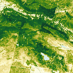
대기권 상단 (TOA) 반사율로 보정된 Landsat 4 TM Collection 1 Tier 1입니다.
보정 계수는 이미지 메타데이터에서 추출됩니다.
TOA 계산에 관한 자세한 내용은 Chander et al. (2009)를 참고하세요.
이러한 컴포지트는 연도의 첫날부터 연도의 마지막 날까지의 각 연간 기간에 있는 모든 장면에서 생성됩니다. 각 연도의 모든 이미지가 컴포지트에 포함되며, 가장 녹색인 픽셀이 컴포지트 값입니다. 여기서 가장 녹색인 픽셀은 정규화된 식생 지수 (NDVI) 값이 가장 높은 픽셀을 의미합니다.
대기권 상단 (TOA) 반사율로 보정된 Landsat 4 TM Collection 1 Tier 1입니다. 보정 계수는 이미지 메타데이터에서 추출됩니다. TOA 계산에 관한 자세한 내용은 Chander et al. (2009)을 참고하세요. 이러한 컴포지트는 연도의 첫날부터 시작하는 각 연간 기간의 모든 장면에서 생성됩니다.
[[["이해하기 쉬움","easyToUnderstand","thumb-up"],["문제가 해결됨","solvedMyProblem","thumb-up"],["기타","otherUp","thumb-up"]],[["필요한 정보가 없음","missingTheInformationINeed","thumb-down"],["너무 복잡함/단계 수가 너무 많음","tooComplicatedTooManySteps","thumb-down"],["오래됨","outOfDate","thumb-down"],["번역 문제","translationIssue","thumb-down"],["샘플/코드 문제","samplesCodeIssue","thumb-down"],["기타","otherDown","thumb-down"]],[],[],["The Landsat 4 TM Collection 1 Tier 1 dataset, available from 1982 to 1993 via Google Earth Engine, provides annual composites of top-of-atmosphere (TOA) reflectance. Composites are created annually, selecting the \"greenest\" pixel with the highest NDVI value from each year's images. The data, with a 30-meter resolution, includes seven spectral bands, a quality assessment (BQA) band, and a greenness index. It is free to use for research, education and nonprofit. The data is public domain and must be acknowledge using \"U.S. Geological Survey\".\n"]]