- Disponibilidade do conjunto de dados
- 1972-07-26T14:46:24Z–1978-01-06T16:11:54Z
- Produtor de conjunto de dados
- USGS
- Tags
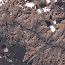
Descrição
Valores de DN do nível 1 da coleção 1 do MSS do Landsat 1, que representam a radiância dimensionada e calibrada no sensor.
As cenas do Landsat com a maior qualidade de dados disponível são colocadas no nível 1 e são consideradas adequadas para análise de processamento de séries temporais. O nível 1 inclui dados processados do terreno de precisão de nível 1 (L1TP) com radiometria bem caracterizada e calibrados entre os diferentes sensores Landsat. O georegistro das cenas de Nível 1 será consistente e dentro das tolerâncias prescritas [raiz do erro quadrático médio (RMSE) de <=12 m]. Todos os dados do Landsat de Nível 1 podem ser considerados consistentes e intercalibrados (independentemente do sensor) em toda a coleção. Confira mais informações nos documentos do USGS.
Bandas
Bandas
| Nome | Tamanho do pixel | Comprimento de onda | Descrição | ||||||||||||||||||||||||||||||||||||||||||||||||||||||||||||||||||||||||||||||||||||||||||||||||
|---|---|---|---|---|---|---|---|---|---|---|---|---|---|---|---|---|---|---|---|---|---|---|---|---|---|---|---|---|---|---|---|---|---|---|---|---|---|---|---|---|---|---|---|---|---|---|---|---|---|---|---|---|---|---|---|---|---|---|---|---|---|---|---|---|---|---|---|---|---|---|---|---|---|---|---|---|---|---|---|---|---|---|---|---|---|---|---|---|---|---|---|---|---|---|---|---|---|---|---|
B4 |
60 metros | 0,5 a 0,6 μm | Verde |
||||||||||||||||||||||||||||||||||||||||||||||||||||||||||||||||||||||||||||||||||||||||||||||||
B5 |
60 metros | 0,6 a 0,7 μm | Vermelho |
||||||||||||||||||||||||||||||||||||||||||||||||||||||||||||||||||||||||||||||||||||||||||||||||
B6 |
60 metros | 0,7 a 0,8 μm | Infravermelho próximo 1 |
||||||||||||||||||||||||||||||||||||||||||||||||||||||||||||||||||||||||||||||||||||||||||||||||
B7 |
30 metros | 0,8 a 1,1 μm | Infravermelho próximo 2 |
||||||||||||||||||||||||||||||||||||||||||||||||||||||||||||||||||||||||||||||||||||||||||||||||
BQA |
60 metros | Máscara de bits de QA da Landsat Collection 1 (consulte a página de QA da Landsat) |
|||||||||||||||||||||||||||||||||||||||||||||||||||||||||||||||||||||||||||||||||||||||||||||||||
Propriedades de imagens
Propriedades da imagem
| Nome | Tipo | Descrição |
|---|---|---|
| CLOUD_COVER | DOUBLE | Porcentagem de cobertura de nuvens (0 a 100), -1 = não calculado. |
| CLOUD_COVER_LAND | DOUBLE | Porcentagem de cobertura de nuvens sobre a terra (0 a 100), -1 = não calculado. |
| COLLECTION_CATEGORY | STRING | Nível da cena. (T1 ou T2) |
| COLLECTION_NUMBER | DOUBLE | Número da coleção. |
| CORRECTION_GAIN_BAND_4 | STRING | Método de ganho de calibragem interna para a banda 4. |
| CORRECTION_GAIN_BAND_5 | STRING | Método interno de ganho de calibragem para a banda 5. |
| CORRECTION_GAIN_BAND_6 | STRING | Método interno de ganho de calibragem para a banda 6. |
| CORRECTION_GAIN_BAND_7 | STRING | Método interno de ganho de calibragem para a banda 7. |
| CPF_NAME | STRING | Nome do arquivo de parâmetro de calibragem. |
| DATA_CATEGORY | STRING | A categoria de dados atual atribuída aos dados. Valores possíveis: ("NOMINAL", "VALIDATION", "EXCHANGE", "TEST", "ENGINEERING") |
| DATA_TYPE | STRING | Identificador do tipo de dados. (L1T ou L1G) |
| DATA_TYPE_L0RP | STRING | String de identificador de tipo de dados usada para criar o produto L0RP. |
| DATE_ACQUIRED | STRING | Data da aquisição da imagem. "AAAA-MM-DD" |
| DATUM | STRING | Dado usado na criação de imagens. |
| EARTH_SUN_DISTANCE | DOUBLE | Distância entre a Terra e o Sol em unidades astronômicas (UA). |
| ELEVATION_SOURCE | STRING | Origem do modelo de elevação usada para produtos padrão corrigidos por terreno (L1T). |
| ELLIPSOID | STRING | Elipsoide usado na criação de imagens. |
| EPHEMERIS_TYPE | STRING | Tipo de dados de efemérides usado para fazer correção geométrica. (Definitivo ou Preditivo) |
| FILE_DATE | DOUBLE | Data do arquivo em milissegundos desde o período. |
| GAIN_BAND_4 | STRING | Ganho de estado para a pulseira 4. (L = ganho baixo, H = ganho alto) |
| GAIN_BAND_5 | STRING | Ganho de estado para a banda 5. (L = ganho baixo, H = ganho alto) |
| GAIN_BAND_6 | STRING | Ganho de estado para a faixa 6. (L = ganho baixo, H = ganho alto) |
| GAIN_BAND_7 | STRING | Ganho de estado para a banda 7. (L = ganho baixo, H = ganho alto) |
| GEOMETRIC_RMSE_MODEL | DOUBLE | Erro quadrático médio combinado (REQM) dos resíduos geométricos (em metros) nas direções transversal (across-track) e longitudinal (along-track), medido nos pontos de controle em terra (GCPs, na sigla em inglês) usados na correção geométrica de precisão. Não está presente nos produtos L1G. |
| GEOMETRIC_RMSE_MODEL_X | DOUBLE | REQM dos resíduos geométricos da direção X (em metros) medido nos GCPs usados na correção de precisão geométrica. Não presente em produtos L1G. |
| GEOMETRIC_RMSE_MODEL_Y | DOUBLE | REQM dos resíduos geométricos da direção Y (em metros) medido nos GCPs usados na correção de precisão geométrica. Não presente em produtos L1G. |
| GEOMETRIC_RMSE_VERIFY | DOUBLE | REQM dos resíduos geométricos (pixels) nas direções de linha e amostra medido no produto corrigido para o terreno de forma independente usando o GLS2000. |
| GEOMETRIC_RMSE_VERIFY_QUAD_LL | DOUBLE | REQM dos resíduos geométricos (pixels) do quadrante inferior esquerdo medido no produto corrigido para o terreno de forma independente usando GLS2000. |
| GEOMETRIC_RMSE_VERIFY_QUAD_LR | DOUBLE | REQM dos resíduos geométricos (pixels) do quadrante inferior direito medido no produto corrigido para o terreno de forma independente usando GLS2000. |
| GEOMETRIC_RMSE_VERIFY_QUAD_UL | DOUBLE | REQM dos resíduos geométricos (pixels) do quadrante superior esquerdo medido no produto corrigido para o terreno de forma independente usando GLS2000. |
| GEOMETRIC_RMSE_VERIFY_QUAD_UR | DOUBLE | REQM dos resíduos geométricos (pixels) do quadrante superior direito medido no produto corrigido para o terreno de forma independente usando GLS2000. |
| GRID_CELL_SIZE_REFLECTIVE | DOUBLE | Tamanho da célula da grade usada na criação da imagem da banda reflexiva. |
| GROUND_CONTROL_POINTS_MODEL | DOUBLE | O número de pontos de controle no solo usados. Não é usado em produtos L1GT. Valores: 0 a 999. O valor 0 é usado para produtos L1T que usaram o refinamento de várias cenas. |
| GROUND_CONTROL_POINTS_VERIFY | DOUBLE | O número de pontos de controle de solo usados na verificação do produto corrigido por terreno. Valores: -1 a 1615 (-1 = não disponível) |
| GROUND_CONTROL_POINTS_VERSION | DOUBLE | O número de pontos de controle de solo usados na verificação do produto corrigido por terreno. Valores: -1 a 1615 (-1 = não disponível) |
| IMAGE_QUALITY | DOUBLE | Qualidade da imagem, 0 = pior, 9 = melhor, -1 = qualidade não calculada |
| LANDSAT_PRODUCT_ID | STRING | A convenção de nomenclatura de cada imagem do Nível 1 da Coleção 1 do Landsat com base nos parâmetros de aquisição e de processamento. Formato: LXSS_LLLL_PPPRRR_YYYYMMDD_yyyymmdd_CC_TX
|
| LANDSAT_SCENE_ID | STRING | A convenção de nomenclatura pré-coleta de cada imagem se baseia em parâmetros de aquisição. Essa era a convenção de nomenclatura usada antes da Coleção 1. Formato: LXSPPPRRRYYYYDDDGSIVV
|
| MAP_PROJECTION | STRING | Projeção usada para representar a superfície tridimensional da Terra para o produto de nível 1. |
| MAP_PROJECTION_L0RA | STRING | Projeção de mapa L0RA aplicada seletivamente a HDTs com base na localização geográfica. Usado para dados de arquivo processados. |
| ORIENTAÇÃO | STRING | Orientação usada na criação da imagem. Valores: NOMINAL = caminho nominal, NORTH_UP = norte para cima, TRUE_NORTH = norte verdadeiro, USER = usuário |
| PRESENT_BAND_4 | STRING | Presença da faixa 4 (Y = Sim, N = Não, M = Ausente, I = Desconhecido) |
| PRESENT_BAND_5 | STRING | Presença da banda 5 (Y = Sim, N = Não, M = Ausente, I = Desconhecido) |
| PRESENT_BAND_6 | STRING | Presença da banda 6 (Y = Sim, N = Não, M = Ausente, I = Desconhecido) |
| PRESENT_BAND_7 | STRING | Presença da banda 7 (Y = Sim, N = Não, M = Ausente, I = Desconhecido) |
| PROCESSING_SOFTWARE_VERSION | STRING | Nome e versão do software de processamento usado para gerar o produto de nível 1. |
| RADIANCE_ADD_BAND_4 | DOUBLE | Fator de reescala aditivo usado para converter DN calibrado em radiância para a banda 4. |
| RADIANCE_ADD_BAND_5 | DOUBLE | Fator de reescala aditivo usado para converter DN calibrado em radiância para a banda 5. |
| RADIANCE_ADD_BAND_6 | DOUBLE | Fator de reescala aditivo usado para converter DN calibrado em radiância para a banda 6. |
| RADIANCE_ADD_BAND_7 | DOUBLE | Fator de reescala aditivo usado para converter DN calibrado em radiância para a banda 7. |
| RADIANCE_MULT_BAND_4 | DOUBLE | Fator de reescala multiplicativo usado para converter o DN da banda 4 calibrada em radiância. |
| RADIANCE_MULT_BAND_5 | DOUBLE | Fator de reescala multiplicativo usado para converter o DN da banda 5 calibrada em radiância. |
| RADIANCE_MULT_BAND_6 | DOUBLE | Fator de reescala multiplicativo usado para converter o DN da banda 6 calibrada em radiância. |
| RADIANCE_MULT_BAND_7 | DOUBLE | Fator de reescala multiplicativo usado para converter o DN da banda 7 calibrada em radiância. |
| REFLECTANCE_ADD_BAND_4 | DOUBLE | Fator de reescala aditivo usado para converter o DN da banda 4 calibrada em refletância. |
| REFLECTANCE_ADD_BAND_5 | DOUBLE | Fator de reescala aditivo usado para converter o DN da banda 5 calibrada em refletância. |
| REFLECTANCE_ADD_BAND_6 | DOUBLE | Fator de reescala aditivo usado para converter o DN da banda 6 calibrada em refletância. |
| REFLECTANCE_ADD_BAND_7 | DOUBLE | Fator de reescala aditivo usado para converter o DN da banda 7 calibrada em refletância. |
| REFLECTANCE_MULT_BAND_4 | DOUBLE | Fator multiplicativo usado para converter o DN da banda 4 calibrada em refletância. |
| REFLECTANCE_MULT_BAND_5 | DOUBLE | Fator multiplicativo usado para converter o DN da banda 5 calibrada em refletância. |
| REFLECTANCE_MULT_BAND_6 | DOUBLE | Fator multiplicativo usado para converter o DN da banda 6 calibrada em refletância. |
| REFLECTANCE_MULT_BAND_7 | DOUBLE | Fator multiplicativo usado para converter o DN da banda 7 calibrada em refletância. |
| REFLECTIVE_LINES | DOUBLE | Número de linhas de produtos para as bandas refletivas. |
| REFLECTIVE_SAMPLES | DOUBLE | Número de amostras de produtos para as bandas reflexivas. |
| REQUEST_ID | STRING | ID da solicitação, nnnyymmdd0000_0000
|
| RESAMPLING_OPTION | STRING | Opção de reamostragem usada na criação da imagem. |
| SATURATION_BAND_4 | STRING | Flag que indica pixels saturados para a banda 4 ("Y"/"N") |
| SATURATION_BAND_5 | STRING | Flag que indica pixels saturados para a banda 5 ("Y"/"N") |
| SATURATION_BAND_6 | STRING | Flag que indica pixels saturados para a banda 6 ("Y"/"N") |
| SATURATION_BAND_7 | STRING | Flag que indica pixels saturados para a banda 7 ("Y"/"N") |
| SCENE_CENTER_TIME | STRING | Tempo do centro da cena da imagem adquirida. HH:MM:SS.SSSSSSSZ
|
| SENSOR_ID | STRING | Sensor usado para capturar dados. |
| SPACECRAFT_ID | STRING | Identificação de espaçonaves. |
| STATION_ID | STRING | Estação terrestre/organização que recebeu os dados. |
| SUN_AZIMUTH | DOUBLE | Ângulo azimutal do Sol em graus para a localização do centro da imagem no momento da aquisição do centro da imagem. |
| SUN_ELEVATION | DOUBLE | Ângulo de elevação do Sol em graus para a localização do centro da imagem no momento da aquisição do centro da imagem. |
| UTM_ZONE | DOUBLE | Número da zona UTM usado na projeção do mapa do produto. |
| WRS_PATH | DOUBLE | O número do caminho orbital do WRS (001 a 251). |
| WRS_ROW | DOUBLE | Linha WRS do satélite Landsat (001 a 248). |
Termos de Uso
Termos de Uso
Os conjuntos de dados do Landsat são criados pelo governo federal e, portanto, pertencem ao domínio público. Eles podem ser usados, transferidos ou reproduzidos sem restrição de direitos autorais.
O USGS precisa ser reconhecido ou creditado como fonte de dados. Para isso, inclua uma linha de citação de texto, como no exemplo abaixo.
(nome do produto, imagem, fotografia ou conjunto de dados), cortesia do Serviço Geológico dos EUA
Exemplo: imagem do Landsat-7, cortesia do Serviço Geológico dos EUA
Consulte as diretrizes do sistema de identidade visual do USGS para mais detalhes sobre a citação e o reconhecimento adequados dos produtos do USGS.