- Phạm vi cung cấp tập dữ liệu
- 2001-01-01T00:00:00Z–2021-01-01T00:00:00Z
- Nhà sản xuất tập dữ liệu
- Uỷ ban Châu Âu, Trung tâm Nghiên cứu chung, Hệ thống thông tin toàn cầu về cháy rừng
- Thẻ
Mô tả
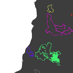
Ranh giới cháy dựa trên tập dữ liệu MODIS MCD64A1. Dữ liệu được tính toán dựa trên một thuật toán phụ thuộc vào việc mã hoá mối quan hệ không gian – thời gian giữa các mảng khu vực bị cháy trong cấu trúc đồ thị.
Mỗi đám cháy có một số riêng biệt để xác định sự kiện.
Giản đồ bảng
Lược đồ bảng
| Tên | Loại | Mô tả |
|---|---|---|
| Giấy tờ tuỳ thân | SLC | Mã dạng số của đám cháy |
| InitialDate | SLC | Ngày kích hoạt ban đầu tính bằng mili giây kể từ ngày 1970-01-01 |
Điều khoản sử dụng
Điều khoản sử dụng
Trích dẫn
Trích dẫn:
Artés, T., Oom, D., De Rigo, D., Durrant, T. H., Maianti, P., Libertà, G., & San-Miguel-Ayanz, J. (2019). Một tập dữ liệu toàn cầu về cháy rừng để phân tích chế độ cháy và hành vi cháy. Scientific data, 6(1), 1-11. doi:10.1038/s41597-019-0312-2
DOI
Khám phá bằng Earth Engine
Trình soạn thảo mã (JavaScript)
// Folder name for a series of tables.
var folder = 'JRC/GWIS/GlobFire/v2/DailyPerimeters';

// List available tables using ee.data.listAssets with asynchronous callback.
function printAssetList(listAssetsOutput) {
  print('Asset list:', listAssetsOutput['assets']);
}
ee.data.listAssets(folder, {}, printAssetList);

// Define a table name (table id) identified from the list of available tables.
var tableName = 'JRC/GWIS/GlobFire/v2/DailyPerimeters/2020';

var computeArea = function(f) {
  return f.set({'area': f.area()});
};

// Import a selected table as a FeatureCollection.
var features = ee.FeatureCollection(tableName).map(computeArea);

// Visualization parameters for linear fire area gradient.
var visParams = {
  palette: ['f5ff64', 'b5ffb4', 'beeaff', 'ffc0e8', '8e8dff', 'adadad'],
  min: 0,
  max: 600000000,
  opacity: 0.8,
};

// Paint fire perimeters to an image using computed fire area as the value property.
var image = ee.Image().float().paint(features, 'area');

// Display the image to the map (include features for exploring with Inspector).
Map.addLayer(image, visParams, 'GlobFire 2020');
Map.addLayer(features, null, 'For Inspector', false);
Map.setCenter(-121.23, 39.7, 12);