- Disponibilidad del conjunto de datos
- 1984-03-16T00:00:00Z–2019-01-01T00:00:00Z
- Proveedor del conjunto de datos
- EC JRC / Google
- Intervalo climatológico
- 1 mes
- Etiquetas
Descripción
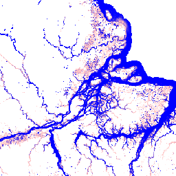
Este conjunto de datos contiene mapas de la ubicación y la distribución temporal de las aguas superficiales de 1984 a 2018, y proporciona estadísticas sobre la extensión y el cambio de esas superficies de agua. Para obtener más información, consulta el artículo de revista asociado: High-resolution mapping of global surface water and its long-term changes (Nature, 2016) y la Guía del usuario de datos en línea.
Estos datos se generaron con 3,865,618 escenas de Landsat 5, 7 y 8 adquiridas entre el 16 de marzo de 1984 y el 31 de diciembre de 2018. Cada píxel se clasificó individualmente como agua o no agua con un sistema experto, y los resultados se recopilaron en un historial mensual para todo el período y dos épocas (1984-1999 y 2000-2018) para la detección de cambios.
La colección de recurrencia mensual contiene 12 imágenes: medidas mensuales de la estacionalidad del agua según los valores de ocurrencia detectados en ese mes durante todos los años.
Bandas
Bandas
Tamaño de píxel: 30 metros (todas las bandas)
| Nombre | Unidades | Mín. | Máx. | Tamaño de los píxeles | Descripción | ||||||||||||||||||||||||||||||||||||||||||||||||||||||||||||||||||||||||||||||||||||||||||||||
|---|---|---|---|---|---|---|---|---|---|---|---|---|---|---|---|---|---|---|---|---|---|---|---|---|---|---|---|---|---|---|---|---|---|---|---|---|---|---|---|---|---|---|---|---|---|---|---|---|---|---|---|---|---|---|---|---|---|---|---|---|---|---|---|---|---|---|---|---|---|---|---|---|---|---|---|---|---|---|---|---|---|---|---|---|---|---|---|---|---|---|---|---|---|---|---|---|---|---|---|
monthly_recurrence |
% | 0 | 100 | 30 metros | Es el valor de recurrencia expresado como un porcentaje para este mes. |
||||||||||||||||||||||||||||||||||||||||||||||||||||||||||||||||||||||||||||||||||||||||||||||
has_observations |
30 metros | Es una marca que indica si el mes tiene observaciones. |
|||||||||||||||||||||||||||||||||||||||||||||||||||||||||||||||||||||||||||||||||||||||||||||||||
Propiedades de imágenes
Propiedades de la imagen
| Nombre | Tipo | Descripción |
|---|---|---|
| mes | DOUBLE | Mes |
Condiciones de Uso
Condiciones de Uso
Todos los datos que se muestran aquí se producen en el marco del Programa Copernicus y se proporcionan sin cargo y sin restricciones de uso. Para obtener la información completa de la licencia, consulta el Reglamento de Copernicus.
Las publicaciones, los modelos y los productos de datos que utilicen estos conjuntos de datos deben incluir el reconocimiento adecuado, lo que incluye citar los conjuntos de datos y el artículo de la revista como en la siguiente cita.
Si utilizas estos datos como una capa en un mapa publicado, incluye el siguiente texto de atribución: "Fuente: CE JRC/Google"
Citas
Jean-Francois Pekel, Andrew Cottam, Noel Gorelick, Alan S. Belward, M. (2015). High-resolution mapping of global surface water and its long-term changes. Nature 540, 418-422 (2016). (doi:10.1038/nature20584)
Explora con Earth Engine
Editor de código (JavaScript)
var dataset = ee.ImageCollection('JRC/GSW1_1/MonthlyRecurrence');

var visualization = {
  bands: ['monthly_recurrence'],
  min: 0.0,
  max: 100.0,
  palette: ['ffffff', 'ffbbbb', '0000ff']
};

Map.setCenter(-51.482, -0.835, 6);

Map.addLayer(dataset, visualization, 'Monthly Recurrence');