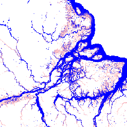
此数据集包含 1984 年至 2015 年地表水的时空分布地图,并提供有关这些水域的范围和变化情况的统计信息。如需了解详情,请参阅相关期刊文章:High-resolution mapping of global surface water and its long-term changes(《自然》,2016 年)和…
[[["易于理解","easyToUnderstand","thumb-up"],["解决了我的问题","solvedMyProblem","thumb-up"],["其他","otherUp","thumb-up"]],[["没有我需要的信息","missingTheInformationINeed","thumb-down"],["太复杂/步骤太多","tooComplicatedTooManySteps","thumb-down"],["内容需要更新","outOfDate","thumb-down"],["翻译问题","translationIssue","thumb-down"],["示例/代码问题","samplesCodeIssue","thumb-down"],["其他","otherDown","thumb-down"]],[],[],["This dataset maps the location and temporal distribution of surface water from 1984 to 2015 using over 3 million Landsat scenes. It classifies each pixel as water or non-water, creating a monthly history of water occurrence. The collection includes 12 images showing monthly water seasonality based on recurrence values. Data includes monthly recurrence percentages and a flag indicating valid observations for each month, all at a 30-meter pixel resolution. The data is available under the Copernicus Programme and free to use.\n"]]