Page Summary
-
The dataset provides global forest/non-forest maps generated from ALOS PALSAR data between 2007 and 2018.
-
The classification defines "forest" based on FAO criteria using radar backscatter intensity.
-
The dataset includes a single band 'fnf' with pixel values representing Forest, Non-Forest, and Water.
-
A newer version of this dataset with 4 classes for 2017-2020 is available in JAXA/ALOS/PALSAR/YEARLY/FNF4.
-
Users must acknowledge JAXA's ownership of the dataset when publishing results.
- Dataset Availability
- 2007-01-01T00:00:00Z–2018-01-01T00:00:00Z
- Dataset Producer
- JAXA EORC
- Tags
Description
A newer version of this dataset with 4 classes for 2017-2020 can be found in JAXA/ALOS/PALSAR/YEARLY/FNF4
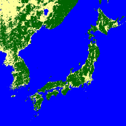
The global forest/non-forest map (FNF) is generated by classifying the SAR image (backscattering coefficient) in the global 25m resolution PALSAR-2/PALSAR SAR mosaic so that strong and low backscatter pixels are assigned as "forest" and "non-forest", respectively. Here, "forest" is defined as the natural forest with the area larger than 0.5 ha and forest cover over 10%. This definition is the same as the Food and Agriculture Organization (FAO) definition. Since the radar backscatter from the forest depends on the region (climate zone), the classification of Forest/Non-Forest is conducted by using a region-dependent threshold of backscatter. The classification accuracy is checked by using in-situ photos and high-resolution optical satellite images. Detailed information is available in the provider's Dataset Description.
Attention:
- Backscatter values may vary significantly from path to path over high latitude forest areas. This is due to the change of backscattering intensity caused by freezing trees in winter. Please note that this may affect the classification of forest/non-forest.
Bands
Bands
Pixel size: 25 meters (all bands)
| Name | Min | Max | Pixel Size | Description |
|---|---|---|---|---|
fnf |
1 | 3 | 25 meters | Forest/Non-Forest landcover classification |
fnf Class Table
| Value | Color | Description |
|---|---|---|
| 1 | #006400 | Forest |
| 2 | #feff99 | Non-Forest |
| 3 | #0000ff | Water |
Terms of Use
Terms of Use
JAXA retains ownership of the dataset and cannot guarantee any problem caused by or possibly caused by using the datasets. Anyone wishing to publish any results using the datasets should clearly acknowledge the ownership of the data in the publication.
Citations
Masanobu Shimada, Takuya Itoh, Takeshi Motooka, Manabu Watanabe, Shiraishi Tomohiro, Rajesh Thapa, and Richard Lucas, "New Global Forest/Non-forest Maps from ALOS PALSAR Data (2007-2010)", Remote Sensing of Environment, 155, pp. 13-31, December 2014. doi:10.1016/j.rse.2014.04.014.
Explore with Earth Engine
Code Editor (JavaScript)
var dataset = ee.ImageCollection('JAXA/ALOS/PALSAR/YEARLY/FNF')
                  .filterDate('2017-01-01', '2017-12-31');
var forestNonForest = dataset.select('fnf');
var forestNonForestVis = {
  min: 1,
  max: 3,
  palette: ['006400', 'feff99', '0000ff'],
};
Map.setCenter(136.85, 37.37, 4);
Map.addLayer(forestNonForest, forestNonForestVis, 'Forest/Non-Forest');