- Disponibilidad del conjunto de datos
- 2009-01-01T00:00:00Z–2021-01-01T00:00:00Z
- Proveedor del conjunto de datos
- IGN
- Etiquetas
Descripción
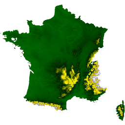
El conjunto de datos ALTI del RGE describe el modelo digital de elevación (MDE) de Francia con un tamaño de píxel de 1 m. Se creó a partir de estudios obtenidos por lidar aéreo o por correlación de imágenes aéreas.
El Lidar se implementó en áreas propensas a inundaciones, costeras y grandes bosques. La precisión vertical del MDT en estas áreas se encuentra entre 0.2 m y 0.5 m. El radar se usó en áreas montañosas (Alpes, Pirineos, Cevenas y Córcega). Precaución: En áreas con pendientes pronunciadas, la precisión vertical promedio es del orden de los 7 m.
La precisión de estos campos se verificó con varias fuentes: las redes viales e hidrográficas de la BD TOPO, las terminales geodésicas y los puntos calculados en el terreno.
En el resto del territorio, se usan técnicas de correlación de fotos aéreas. En ciertas zonas tratadas por correlación, no hay mediciones terrestres en grandes extensiones debido a la presencia de vegetación (por ejemplo, áreas boscosas). Para completar estos vacíos, se usan datos de altimetría de 1987 a 2001 (BD Alti). La precisión vertical del MDT en estas áreas se encuentra entre 0.5 m y 0.7 m.
Actualmente, la colección incluye una sola imagen IGN/RGE_ALTI/1M/2_0/FXX que muestra la Francia metropolitana.
Este conjunto de datos se preparó y se transfirió con la ayuda de Guillaume Attard y Julien Bardonnet (AGEOCE). El proceso de preparación se describe aquí.
Consulta también la guía del usuario.
Bandas
Bandas
Tamaño de píxel: 1 metro (todas las bandas)
| Nombre | Unidades | Mín. | Máx. | Tamaño de los píxeles | Descripción |
|---|---|---|---|---|---|
MNT |
m | -40* | 4,810* | 1 metro | Elevación del terreno en metros. |
SRC |
1 metro | Es la fuente principal de los datos que se usan para calcular la altitud del nodo. Consulta el Apéndice B, página 26, en la guía del usuario. |
|||
DST |
m | 0 | 255 | 1 metro | Es la distancia en metros entre el nodo y el punto más cercano que se usa para calcular su altitud. |
Condiciones de Uso
Condiciones de Uso
Citas
IGN (2021). RGE ALTI 1m [Conjunto de datos]. Fecha de acceso: 1 de julio de 2022, desde el sitio web de IGN
Explora con Earth Engine
Editor de código (JavaScript)
var dataset = ee.Image('IGN/RGE_ALTI/1M/2_0/FXX');
var elevation = dataset.select('MNT');

var elevationVis = {
  min: 0,
  max: 1000,
  palette: ['006600', '002200', 'fff700', 'ab7634', 'c4d0ff', 'ffffff']
};

Map.addLayer(elevation, elevationVis, 'Elevation');
Map.setCenter(3, 47, 5);