Page Summary
-
The dataset provides digital orthophotos covering the Brandenburg state of Germany with a pixel size of 0.2 meters.
-
The dataset is available from 2021-08-23 to 2023-01-20 and includes bands for Near infrared, Red, Green, and Blue.
-
Terms of use require attribution to the provider, reference to the data license, and a link to the dataset URI.
- Dataset Availability
- 2021-08-23T00:00:00Z–2023-01-20T00:00:00Z
- Dataset Producer
- Brandenburg orthophotos
- Tags
Description
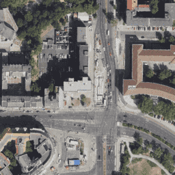
Orthophotos are an aerial photo dataset covering the Brandenburg state of Germany. This data is provided by State government of Brandenburg (LGB). Digital orthophotos are digitally corrected aerial photos and show all objects that are visible from the air at the time of recording in a parallel perspective. They have a high density of information on ecological, phenological, geographical and other topics.
For more information, please see the Brandenburg orthophotos documentation
Bands
Bands
Pixel size: 0.2 meters (all bands)
| Name | Min | Max | Pixel Size | Description |
|---|---|---|---|---|
N |
0 | 255 | 0.2 meters | Near infrared |
R |
0 | 255 | 0.2 meters | Red |
G |
0 | 255 | 0.2 meters | Green |
B |
0 | 255 | 0.2 meters | Blue |
Terms of Use
Terms of Use
The user must ensure that the source note contains the following information:
- the name of the provider,
- the annotation "Data licence Germany - attribution - Version 2.0" or "dl-de/by-2-0" referring to the licence text available at www.govdata.de/dl-de/by-2-0, and
- a reference to the dataset (URI). This applies only if the entity keeping the data provides the pieces of information 1-3 for the source note.
Changes, editing, new designs or other amendments must be marked as such in the source note.
For more details please see the Terms of use
Citations
Data License Germany - Attribution - Version 2.0
Explore with Earth Engine
Code Editor (JavaScript)
var dataset = ee.Image('Germany/Brandenburg/orthos/20cm');
Map.setCenter(13.386091, 52.507899, 18);
Map.addLayer(dataset, null, 'Brandenburg 20cm');