- Доступность набора данных
- 2000-02-17T00:00:00Z–2018-12-10T00:00:00Z
- Производитель наборов данных
- Cloud to Street (C2S) / Dartmouth Flood Observatory (DFO)
- Теги
- c2
Описание
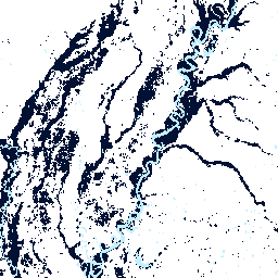
The Global Flood Database contains maps of the extent and temporal distribution of 913 flood events occurring between 2000-2018. For more information, see the associated journal article .
Данные о наводнениях были собраны в Дартмутской обсерватории по изучению наводнений и использованы для получения изображений MODIS. Были отобраны 913 событий, которые были успешно нанесены на карту (прошли контроль качества как имеющие значительное затопление, выходящее за рамки постоянной воды) с использованием 12 719 сцен с датчиков MODIS Terra и Aqua. Каждый пиксель был классифицирован как вода или не вода с разрешением 250 метров в течение всего диапазона дат каждого наводнения, и были сгенерированы последующие данные, включая максимальную площадь затопления («затопленная» полоса) и продолжительность затопления в днях («продолжительность» полоса). Классификация воды и не воды во время наводнения включает постоянную воду (здесь передискретизация 30-метрового набора данных JRC Global Surface Water, представляющего постоянную воду, до разрешения 250 метров), которую можно замаскировать для выделения паводковой воды с помощью полосы «jrc_perm_water». Были добавлены дополнительные диапазоны качества данных, отражающие облачность во время наводнения (например, "clear_views" обозначает количество ясных дней, в течение которых наблюдалось наводнение между его началом и концом, а "clear_perc" — процент ясных дней от общей продолжительности события в днях).
Each image in the ImageCollection represents the map of an individual flood. The collection can be filtered by date, country, or Dartmouth Flood Observatory original ID.
Группы
Группы
Размер пикселя: 30 метров (все диапазоны)
| Имя | Единицы | Мин | Макс | Размер пикселя | Описание |
|---|---|---|---|---|---|
flooded | 0 | 1 | 30 метров | Максимальный объем паводковых вод во время стихийного бедствия.
| |
duration | д | 0 | 65535 | 30 метров | Duration of surface water during an event in days. Pixel values indicate the number of composite days a pixel's area was considered water during an event. 3-day MODIS composites were used. |
clear_views | д | 0 | 65535 | 30 метров | Number of cloud-free observations in days between the start and end day of each event. Cloud coverage is determined by the MODIS Quality Assurance band ('state_1km'). |
clear_perc | % | 0 | 100 | 30 метров | Процент наблюдений с безоблачным небом во время данного наводнения. Это эквивалентно полосе 'clear_views', но нормализовано по количеству изображений MODIS за одно наводнение. Облачность определяется полосой контроля качества MODIS 'state_1km'. |
jrc_perm_water | 0 | 1 | 30 метров | Permanent water determined by the JRC Global Surface Water dataset using the 'transition' band. Resolution is maintained as the original 30-meter resolution of the JRC dataset.
|
Свойства изображения
Свойства изображения
| Имя | Тип | Описание |
|---|---|---|
| идентификатор | ИНТ | Unique catalog ID of flood event that aligns with the Dartmouth Flood Observatory (DFO). |
| cc | НИТЬ | Three-letter ISO country codes (in a list) for countries for which flood water was detected in watersheds intersecting the DFO event polygon. |
| страны | НИТЬ | Country names (in a list) for countries for which flood water was detected in watersheds intersecting the DFO event polygon. |
| dfo_centroid_x | ДВОЙНОЙ | Centroid longitude of DFO polygon estimating the location of a flood event (DFO database). |
| dfo_centroid_y | ДВОЙНОЙ | Centroid latitude of DFO polygon estimating the location of a flood event (DFO database). |
| dfo_country | НИТЬ | Основная страна, пострадавшая от наводнения (база данных DFO). |
| dfo_other_country | НИТЬ | Второстепенная страна, пострадавшая от наводнения (база данных DFO). |
| dfo_displaced | ИНТ | Estimated total number of people left homeless or evacuated after a flood event (DFO database). |
| dfo_main_cause | НИТЬ | The main cause of a flood event in the DFO database. Not normalized. |
| dfo_severity | ДВОЙНОЙ | Степень тяжести наводнения (база данных DFO):
|
| dfo_dead | ИНТ | Estimated fatalities due to a flood event (DFO database). |
| dfo_validation_type | НИТЬ | Primary source of flood event confirmation (DFO database). Not normalized. |
| glide_index | НИТЬ | |
| gfd_country_code | НИТЬ | Comma-separated list of two-letter FIPS country codes for countries intersecting with the watershed used as the area of interest in the water detection algorithm. |
| gfd_country_name | НИТЬ | Country names (in a list) for countries intersecting with the watershed used as the area of interest in the water detection algorithm. |
| composite_type | НИТЬ | Number of days used for compositing in water detection algorithm. |
| threshold_type | НИТЬ | Type of thresholds used to classify water/ non-water in water detection algorithm - "otsu" or "standard". |
| threshold_b1b2 | ДВОЙНОЙ | Threshold value applied to the b2b1-ratio used in the water detection algorithm. |
| threshold_b7 | ДВОЙНОЙ | Threshold value applied to band 7 (SWIR) used in the water detection algorithm. |
| otsu_sample_res | ДВОЙНОЙ | Пространственное разрешение (в м) редуктора, используемого для построения мозаики MODIS, на основе которой затем производится выборка и оценка порогового значения Оцу (доступно только для наводнений, в которых использовалось значение Оцу, а не пороговое значение по умолчанию). |
| slope_threshold | ДВОЙНОЙ | Value used to mask steep areas from water detection algorithm to minimize error from terrain shadows. |
Условия эксплуатации
Условия эксплуатации
This work is licensed under the Creative Commons Attribution Non Commercial 4.0 International license.
Цитаты
Теллман, Б., Дж. А. Салливан, К. Кун, А. Дж. Кеттнер, К. С. Дойл, Г. Р. Бракенридж, Т. Эриксон, Д. А. Слейбэк. (Принято к публикации.) Спутники наблюдают за увеличением доли населения, подверженного наводнениям. Nature. doi:10.1038/s41586-021-03695-w
Исследуйте мир с помощью Earth Engine.
Редактор кода (JavaScript)
var gfd = ee.ImageCollection('GLOBAL_FLOOD_DB/MODIS_EVENTS/V1');

// An individual flood event - flooding due to Hurricane Isaac in the USA.
var hurricaneIsaacDartmouthId = 3977;
var hurricaneIsaacUsa = ee.Image(
    gfd.filterMetadata('id', 'equals', hurricaneIsaacDartmouthId).first());
Map.setOptions('SATELLITE');
Map.setCenter(-90.2922, 29.4064, 9);
Map.addLayer(
  hurricaneIsaacUsa.select('flooded').selfMask(),
  {min: 0, max: 1, palette: '001133'},
  'Hurricane Isaac - Inundation Extent');

// The duration (number of days a flood event lasted).
var durationPalette = ['c3effe', '1341e8', '051cb0', '001133'];
Map.addLayer(
  hurricaneIsaacUsa.select('duration').selfMask(),
  {min: 0, max: 4, palette: durationPalette},
  'Hurricane Isaac - Duration');

// Map all floods to generate the satellite-observed historical flood plain.
var gfdFloodedSum = gfd.select('flooded').sum();
Map.addLayer(
  gfdFloodedSum.selfMask(),
  {min: 0, max: 10, palette: durationPalette},
  'GFD Satellite Observed Flood Plain');

// Overlay permanent water to distinguish flood water.
var jrc = gfd.select('jrc_perm_water').sum().gte(1);
Map.addLayer(
  jrc.selfMask(),
  {min: 0, max: 1, palette: 'C3EFFE'},
  'JRC Permanent Water');