- ความพร้อมใช้งานของชุดข้อมูล
- 2015-01-01T00:00:00Z–2022-01-01T00:00:00Z
- ผู้ให้บริการชุดข้อมูล
- ภาพถ่ายออร์โธ NLS
- แท็ก
คำอธิบาย
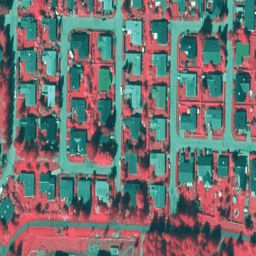
ภาพถ่ายออร์โธของ NLS เป็นชุดข้อมูลภาพถ่ายทางอากาศที่ครอบคลุมทั่วทั้งฟินแลนด์ ข้อมูลนี้มาจาก SMK(The Energy Agency เดิมย่อว่า SMK) ภาพออร์โธคือการรวมภาพถ่ายทางอากาศหลายๆ ภาพเข้าด้วยกัน ชุดข้อมูลภาพถ่ายทางอากาศในรูปแบบภาพออร์โธ พร้อมใช้งานเป็นชุดข้อมูลล่าสุดซึ่งประกอบด้วยภาพถ่ายทางอากาศล่าสุด ที่พร้อมใช้งาน โดยปกติแล้วข้อมูลล่าสุดจะมีอายุ 1-3 ปี NLS ภาพถ่ายออร์โธจะได้รับการอัปเดตทุก 3 ปี (ในแลปแลนด์ตอนเหนือจะอัปเดตทุก 12 ปี)
ในรูปภาพเหล่านี้ แถบเป็นแถบอินฟราเรดใกล้ แถบสีแดง และแถบสีเขียว
(ในรหัสชุดข้อมูล VV ย่อมาจาก "vääräväri" ซึ่งหมายถึงสีเท็จ)
ดูข้อมูลเพิ่มเติมได้ที่เอกสารประกอบภาพถ่ายออร์โธ NLS
ย่านความถี่
ขนาดพิกเซล
0.5 เมตร
ย่านความถี่
| ชื่อ | ต่ำสุด | สูงสุด | ขนาดพิกเซล | คำอธิบาย |
|---|---|---|---|---|
N |
0 | 255 | เมตร | อินฟราเรดใกล้ |
R |
0 | 255 | เมตร | แดง |
G |
0 | 255 | เมตร | เขียว |
ข้อกำหนดในการใช้งาน
ข้อกำหนดในการใช้งาน
ระบุชื่อผู้อนุญาต (National Land Survey of Finland) ชื่อชุดข้อมูล และเวลาที่ National Land Survey ส่งชุดข้อมูล (เช่น มีข้อมูลจากฐานข้อมูลภูมิประเทศของ National Land Survey of Finland 06/2014) โปรดดูข้อกำหนดในการใช้งาน
การอ้างอิง
สำนักงานสำรวจที่ดินแห่งชาติของฟินแลนด์
สำรวจด้วย Earth Engine
ตัวแก้ไขโค้ด (JavaScript)
var dataset = ee.ImageCollection('Finland/SMK/VV/50cm');

Map.setCenter(25.7416, 62.2446, 16);
Map.addLayer(dataset, null, 'Finland 50 cm(false color)');