- ความพร้อมใช้งานของชุดข้อมูล
- 2020-01-01T00:00:00Z–2021-12-31T23:59:59Z
- ผู้ผลิตชุดข้อมูล
- ESA WorldCereal Consortium
- แท็ก
คำอธิบาย
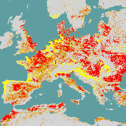
ชุดผลิตภัณฑ์ WorldCereal 10 ม. ปี 2021 ของ European Space Agency (ESA) ประกอบด้วย แผนที่พืชผลประจำปีและตามฤดูกาลระดับโลก รวมถึงความน่าเชื่อถือที่เกี่ยวข้อง โดยสร้างขึ้นเพื่อเป็นส่วนหนึ่งของโปรเจ็กต์ ESA-WorldCereal ดูข้อมูลเพิ่มเติมเกี่ยวกับ เนื้อหาของผลิตภัณฑ์เหล่านี้และระเบียบวิธีที่ใช้ในการสร้างได้ใน [1]
คอลเล็กชันนี้มีรูปภาพเขตเกษตรนิเวศ (AEZ) สูงสุด 106 รูปสำหรับ ผลิตภัณฑ์แต่ละรายการ ซึ่งทั้งหมดได้รับการประมวลผลตามฤดูกาลในภูมิภาคของตนเอง และควรพิจารณาเป็นผลิตภัณฑ์อิสระ ฤดูกาลเหล่านี้ อธิบายไว้ในรายการด้านล่างและได้รับการพัฒนาใน [2] ซึ่งเป็นส่วนหนึ่งของ โปรเจ็กต์ โปรดทราบว่าซีเรียลตามที่ WorldCereal อธิบายรวมถึงข้าวสาลี ข้าวบาร์เลย์ และข้าวไรย์ ซึ่งอยู่ในเผ่า Triticeae
คำอธิบายฤดูกาลของ WorldCereal
- tc-annual: รอบ 1 ปีที่กำหนดใน AEZ ภายในสิ้นสุดฤดูปลูกที่พิจารณาล่าสุด
- tc-wintercereals: ฤดูปลูกธัญพืชหลักที่กำหนดไว้ใน AEZ
- tc-springcereals: ฤดูปลูกธัญพืชฤดูใบไม้ผลิที่ไม่บังคับ กำหนดไว้ใน AEZ บางแห่งเท่านั้น
- tc-maize-main: ฤดูปลูกข้าวโพดหลักที่กำหนดไว้ใน AEZ
- tc-maize-second: ฤดูปลูกข้าวโพดที่ 2 (ไม่บังคับ) กำหนดไว้ใน AEZ บางแห่งเท่านั้น
ผลิตภัณฑ์ที่พร้อมใช้งานในคอลเล็กชันนี้ ได้แก่
- temporarycrops
- Maize
- wintercereals
- springcereals
- การชลประทาน
ผลิตภัณฑ์ (รูปภาพ) แต่ละรายการมีการจัดประเภทแบบไบนารี (0 หรือ 100) และช่วงความเชื่อมั่น (0-100) โปรดทราบว่าระบบไม่ได้ประมวลผล AEZ ที่ไม่มีผลิตภัณฑ์ชลประทาน เนื่องจากไม่มีข้อมูล Landsat ความร้อน
ควรกรองคอลเล็กชันโดยใช้พร็อพเพอร์ตี้รูปภาพต่อไปนี้อย่างน้อย 1 รายการ
- aez_id ซึ่งมีรหัสของ AEZ ที่รูปภาพเป็นของ
- ผลิตภัณฑ์ โดยอธิบายชื่อผลิตภัณฑ์ WorldCereal ของรูปภาพ
- season โดยอธิบายซีซันที่รูปภาพใช้ได้
ข้อมูลอ้างอิง:
- [1] เอกสารเกี่ยวกับระเบียบวิธีและผลิตภัณฑ์ของ WorldCereal
- [2] เอกสารเกี่ยวกับฤดูกาลทั่วโลกของ WorldCereal
ชุดข้อมูล WorldCereal
- เวอร์ชัน 100 สำหรับปี 2021
ย่านความถี่
ย่านความถี่
ขนาดพิกเซล: 10 เมตร (ทุกแถบ)
| ชื่อ | ต่ำสุด | สูงสุด | ขนาดพิกเซล | คำอธิบาย |
|---|---|---|---|---|
classification |
0 | 100 | 10 เมตร | การแยกประเภท: 0 หรือ 100 |
confidence |
0 | 100 | 10 เมตร | ความมั่นใจ 0 ถึง 100 |
พร็อพเพอร์ตี้รูปภาพ
พร็อพเพอร์ตี้รูปภาพ
| ชื่อ | ประเภท | คำอธิบาย |
|---|---|---|
| aez_id | INT | รหัสของเขตเกษตรนิเวศ (AEZ) ที่ผลิตภัณฑ์เป็นของ |
| ผลิตภัณฑ์ | STRING | ชื่อผลิตภัณฑ์ WorldCereal |
| season | STRING | ฤดูกาลที่ผลิตภัณฑ์ใช้งานได้ |
ข้อกำหนดในการใช้งาน
ข้อกำหนดในการใช้งาน
การอ้างอิง
Van Tricht, K., Degerickx, J., Gilliams, S., Zanaga, D., Battude, M., Grosu, A., Brombacher, J., Lesiv, M., Bayas, J. ค. L., Karanam, S., Fritz, S., Becker-Reshef, I., Franch, B., Mollà-Bononad, B., Boogaard, H., Pratihast, A. K., and Szantoi, Z.: WorldCereal: ระบบโอเพนซอร์สแบบไดนามิกสำหรับ การทำแผนที่พืชผลและการชลประทานระดับโลกตามฤดูกาลและทำซ้ำได้, Earth Syst. Sci. Data Discuss. [preprint], doi:10.5194/essd-2023-184, in review, 2023.,
DOI
สำรวจด้วย Earth Engine
ตัวแก้ไขโค้ด (JavaScript)
var dataset = ee.ImageCollection('ESA/WorldCereal/2021/MODELS/v100')

// Set satellite background
Map.setOptions('SATELLITE');

// Typically we'd want to mask the "other" class (value 0)
// in the images
function mask_other(img) {
  return img.updateMask(img.neq(0))
}

// Apply the mask_other function to the collection
dataset = dataset.map(mask_other);

/*--------------------------------------------------
Basic example for a global mosaic of temporary crops
--------------------------------------------------*/

// Get a global mosaic for all agro-ecological zone (AEZ) of temporary crops
var temporarycrops = dataset.filter('product == "temporarycrops"').mosaic();

// Visualization specifics
var visualization_class = {
  bands: ["classification"],
  max: 100,
  palette: ["ff0000"]
};

var visualization_conf = {
  bands: ['confidence'],
  min: [0],
  max: [100],
  palette: ['be0000','fff816','069711'],
};

// Show global classification mosaic
Map.centerObject(temporarycrops);
Map.addLayer(temporarycrops, visualization_class, 'Temporary crops');

// By default don't show confidence layer
Map.addLayer(
    temporarycrops, visualization_conf, 'Temporary crops confidence', false);

/*--------------------------------------------------
Advanced example for tc-maize-main season products
in a specific AEZ
--------------------------------------------------*/

// Filter on AEZ and season
var tc_maize_main_46172 = dataset.filter(
  ee.Filter.eq('season', 'tc-maize-main')
  ).filter(ee.Filter.eq('aez_id', 46172));

// Get the different products
var maize = tc_maize_main_46172.filter('product == "maize"');
var irrigation = tc_maize_main_46172.filter('product == "irrigation"');

// Visualization specifics
var visualization_maize = {
  bands: ["classification"],
  max: 100,
  palette: ["#ebc334"]
};

var visualization_irrigation = {
  bands: ["classification"],
  max: 100,
  palette: ["#2d79eb"]
};

// Show maize and irrigation classification
Map.addLayer(maize, visualization_maize, 'Maize');
Map.addLayer(irrigation, visualization_irrigation, 'Active irrigation');

// Uncomment the line below to zoom to a region
// where maize, other crops and active irrigation are visible
// Map.setCenter(-0.9911, 43.5017, 12)