Page Summary
-
The FireCCI51 dataset provides monthly global burned area information at approximately 250m resolution from 2001 to 2020, based on MODIS data.
-
The dataset includes estimated burn date, confidence level, and burned land cover information, along with observation flags.
-
FireCCI51 uses a hybrid algorithm combining active fire detection and contextual growing based on the Near Infrared (NIR) band.
-
This dataset was developed as part of the ESA Climate Change Initiative (CCI) Programme and is also included in the Copernicus Climate Change Service (C3S).
-
The dataset is free and open to all users, with requirements for acknowledgment and citation of the data providers.
- Dataset Availability
- 2001-01-01T00:00:00Z–2020-12-01T00:00:00Z
- Dataset Producer
- European Space Agency (ESA) Climate Change Initiative (CCI) Programme, Fire ECV
- Cadence
- 1 Month
- Tags
Description
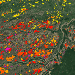
The MODIS Fire_cci Burned Area pixel product version 5.1 (FireCCI51) is a monthly global ~250m spatial resolution dataset containing information on burned area as well as ancillary data. It is based on surface reflectance in the Near Infrared (NIR) band from the MODIS instrument onboard the Terra satellite, as well as active fire information from the same sensor of the Terra and Aqua satellites.
The burned area algorithm uses a two-phase hybrid approach. In a first step pixels with a high probability of being burned (called "seeds") are detected based on the active fires. In a second one, a contextual growing is applied to completely detect the fire patch. This growing phase is controlled by an adaptive thresholding, where thresholds are computed based on the specific characteristics of the area surrounding each seed. The variable used to guide the whole detection process is the NIR drop between pre- and post-fire images.
The dataset includes for each pixel the estimated day of the first detection of the fire, the confidence level of that detection, and the land cover that has been burned (extracted from the ESA CCI Land Cover dataset v2.0.7). In addition, an observation flag is provided to identify the pixels that were not processed due to the lack of valid observations or because they belong to a non-burnable land cover.
FireCCI51 was developed as part of the ESA Climate Change Initiative (CCI) Programme, and it is also part of the Copernicus Climate Change Service (C3S).
Bands
Bands
Pixel size: 250 meters (all bands)
| Name | Units | Min | Max | Pixel Size | Description |
|---|---|---|---|---|---|
BurnDate |
1 | 366 | 250 meters | Estimated day of the year of the first detection of the burn |
|
ConfidenceLevel |
% | 1 | 100 | 250 meters | Probability of detecting a pixel as burned, expressing the uncertainty of the detection for all pixels, even if they are classified as unburned. |
LandCover |
250 meters | Land cover category of the burned pixels, extracted from the CCI LandCover v2.0.7 product. See Defourny, P., Lamarche, C., Bontemps, S., De Maet, T., Van Bogaert, E., Moreau, I., Brockmann, C., Boettcher, M., Kirches, G., Wevers, J., Santoro, M., Ramoino, F., & Arino, O. (2017). Land Cover Climate Change Initiative - Product User Guide v2. Issue 2.0. [online] Available at: https://maps.elie.ucl.ac.be/CCI/viewer/download/ESACCI-LC-Ph2-PUGv2_2.0.pdf accessed: July 2020. © ESA Climate Change Initiative - Land Cover led by UCLouvain (2017). |
|||
ObservedFlag |
250 meters | Flags indicating why a pixel was not processed.
|
LandCover Class Table
| Value | Color | Description |
|---|---|---|
| 0 | #000000 | No Data |
| 10 | #ffff64 | Cropland, rainfed |
| 20 | #aaf0f0 | Cropland, irrigated or post-flooding |
| 30 | #dcf064 | Mosaic cropland (>50%) / natural vegetation (tree, shrub, herbaceous cover) (<50%) |
| 40 | #c8c864 | Mosaic natural vegetation (tree, shrub, herbaceous cover) (>50%) / cropland (<50%) |
| 50 | #006400 | Tree cover, broadleaved, evergreen, closed to open (>15%) |
| 60 | #00a000 | Tree cover, broadleaved, deciduous, closed to open (>15%) |
| 70 | #003c00 | Tree cover, needleleaved, evergreen, closed to open (>15%) |
| 80 | #285000 | Tree cover, needleleaved, deciduous, closed to open (>15%) |
| 90 | #788200 | Tree cover, mixed leaf type (broadleaved and needleleaved) |
| 100 | #8ca000 | Mosaic tree and shrub (>50%) / herbaceous cover (<50%) |
| 110 | #be9600 | Mosaic herbaceous cover (>50%) / tree and shrub (<50%) |
| 120 | #966400 | Shrubland |
| 130 | #ffb432 | Grassland |
| 140 | #ffdcd2 | Lichens and mosses |
| 150 | #ffebaf | Sparse vegetation (tree, shrub, herbaceous cover) (<15%) |
| 170 | #009678 | Tree cover, flooded, saline water |
| 180 | #00dc82 | Shrub or herbaceous cover, flooded, fresh/saline/brackish water |
Terms of Use
Terms of Use
This dataset is free and open to all users for any purpose, with the following terms and conditions:
Users of the data are required to acknowledge the ESA Climate Change Initiative and the Fire CCI project together with the individual data providers if the data are used in a presentation or publication. Please also cite any relevant dataset DOIs.
Intellectual property rights (IPR) in the CCI data lie with the researchers and organisations producing the data.
Liability: no warranty is given as to the quality or the accuracy of the CCI data or its suitability for any use. All implied conditions relating to the quality or suitability of the information, and all liabilities arising from the supply of the information (including any liability arising in negligence) are excluded to the fullest extent permitted by law.
Citations
Padilla Parellada, M. (2018): ESA Fire Climate Change Initiative (Fire_cci): MODIS Fire_cci Burned Area Pixel product, version 5.1. Centre for Environmental Data Analysis, 01 November 2018. https://doi.org/10.5285/58f00d8814064b79a0c49662ad3af537.
Related publication: Lizundia-Loiola, J., Otón, G., Ramo, R., Chuvieco, E. (2020): A spatio-temporal active-fire clustering approach for global burned area mapping at 250m from MODIS data. Remote Sensing of Environment, 236, 111493. https://doi.org/10.1016/j.rse.2019.111493
DOIs
Explore with Earth Engine
Code Editor (JavaScript)
// Visualize FireCCI51 for one year
var dataset = ee.ImageCollection('ESA/CCI/FireCCI/5_1')
                  .filterDate('2020-01-01', '2020-12-31');
var burnedArea = dataset.select('BurnDate');

// Use a circular palette to assign colors to date of first detection
var baVis = {
  min: 1,
  max: 366,
  palette: [
    'ff0000', 'fd4100', 'fb8200', 'f9c400', 'f2ff00', 'b6ff05',
    '7aff0a', '3eff0f', '02ff15', '00ff55', '00ff99', '00ffdd',
    '00ddff', '0098ff', '0052ff', '0210ff', '3a0dfb', '7209f6',
    'a905f1', 'e102ed', 'ff00cc', 'ff0089', 'ff0047', 'ff0004'
  ]
};
var maxBA = burnedArea.max();

Map.setCenter(0, 18, 2.1);
Map.addLayer(maxBA, baVis, 'Burned Area');
import ee
import geemap.core as geemap
Colab (Python)
# Visualize FireCCI51 for one year
dataset = ee.ImageCollection('ESA/CCI/FireCCI/5_1').filterDate(
    '2020-01-01', '2020-12-31'
)

burned_area = dataset.select('BurnDate')
max_ba = burned_area.max()

# Use a circular palette to assign colors to date of first detection
ba_vis = {
    'min': 1,
    'max': 366,
    'palette': [
        'ff0000', 'fd4100', 'fb8200', 'f9c400', 'f2ff00', 'b6ff05',
        '7aff0a', '3eff0f', '02ff15', '00ff55', '00ff99', '00ffdd',
        '00ddff', '0098ff', '0052ff', '0210ff', '3a0dfb', '7209f6',
        'a905f1', 'e102ed', 'ff00cc', 'ff0089', 'ff0047', 'ff0004'
    ],
}

m = geemap.Map()
m.set_center(0, 18, 2.1)
m.add_layer(max_ba, ba_vis, 'Burned Area')
m