- Disponibilité de l'ensemble de données
- 2006-01-24T00:00:00Z–2011-05-13T00:00:00Z
- Producteur de l'ensemble de données
- Conservation Science Partners
- Tags
Description
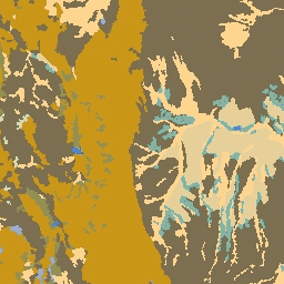
L'ensemble de données sur la lithologie fournit des classes de types généraux de matériau parent du sol en surface. Il ne provient d'aucun MNE.
Les ensembles de données, les formes de relief et la physiographie (également appelées facettes terrestres) de la Conservation Science Partners (CSP) Ecologically Relevant Geomorphology (ERGo) contiennent des données détaillées et multiscalaires sur les formes de relief et les modèles physiographiques. Bien que ces données puissent être utilisées de nombreuses façons, leur objectif initial était de développer une classification et une carte écologiquement pertinentes des formes de relief et des classes physiographiques adaptées à la planification de l'adaptation au changement climatique. Étant donné la grande incertitude associée aux futures conditions climatiques et l'incertitude encore plus grande concernant les réponses écologiques, fournir des informations sur ce qui est peu susceptible de changer constitue une base solide pour permettre aux gestionnaires d'élaborer des plans d'adaptation au changement climatique robustes. La quantification de ces caractéristiques du paysage est sensible à la résolution. Nous fournissons donc la résolution la plus élevée possible compte tenu de l'étendue et des caractéristiques d'un indice donné.
Bandes
Bandes de fréquences
Taille des pixels : 90 mètres (toutes les bandes)
| Nom | Taille des pixels | Description |
|---|---|---|
b1 |
90 mètres | Classes de lithologie |
Tableau des classes b1
| Valeur | Couleur | Description |
|---|---|---|
| 0 | #356eff | Eau |
| 1 | #acb6da | Carbonate |
| 3 | #d6b879 | Non carbonaté |
| 4 | #313131 | Intrusif alcalin |
| 5 | #eda800 | Résidu silicique |
| 7 | #616161 | Volcanique extrusif |
| 8 | #d6d6d6 | Sédiments colluviaux |
| 9 | #d0ddae | Argile de till glaciaire |
| 10 | #b8d279 | Loam de till glaciaire |
| 11 | #d5d378 | Till glaciaire grossier |
| 13 | #141414 | Amende pour sédiments fins de lac glaciaire |
| 14 | #6db155 | Dépôts fluvioglaciaires grossiers |
| 15 | #9b6d55 | Hydrique |
| 16 | #feeec9 | Sédiments éoliens grossiers |
| 17 | #d6b879 | Sédiments éoliens fins |
| 18 | #00b7ec | Sédiments de lac salé |
| 19 | #ffda90 | Alluvions et sédiments côtiers fins |
| 20 | #f8b28c | Sédiments côtiers grossiers |
Conditions d'utilisation
Conditions d'utilisation
Citations
Theobald, D. M., Harrison-Atlas, D., Monahan, W. B. & Albano, C. M. (2015). Cartes écologiquement pertinentes des formes de relief et de la diversité physiographique pour la planification de l'adaptation au changement climatique. PloS one, 10(12), e0143619
Explorer avec Earth Engine
Éditeur de code (JavaScript)
var dataset = ee.Image('CSP/ERGo/1_0/US/lithology');
var lithology = dataset.select('b1');
var lithologyVis = {
  min: 0.0,
  max: 20.0,
  palette: [
    '356eff', 'acb6da', 'd6b879', '313131', 'eda800', '616161', 'd6d6d6',
    'd0ddae', 'b8d279', 'd5d378', '141414', '6db155', '9b6d55', 'feeec9',
    'd6b879', '00b7ec', 'ffda90', 'f8b28c'
  ],
};
Map.setCenter(-105.8636, 40.3439, 11);
Map.addLayer(lithology, lithologyVis, 'Lithology');