- Disponibilidad del conjunto de datos
- 2006-01-24T00:00:00Z–2011-05-13T00:00:00Z
- Proveedor del conjunto de datos
- Conservation Science Partners
- Etiquetas
Descripción
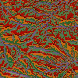
El conjunto de datos de formas del terreno de ALOS proporciona clases de formas del terreno creadas combinando el índice de carga continua de insolación y calor (CHILI) y los conjuntos de datos del índice de posición topográfica multiescala (mTPI). Se basa en el DEM NED de 10 m del USGS (disponible en EE.UU. como USGS/NED).
Los conjuntos de datos, las formas terrestres y la fisiografía de la geomorfología ecológicamente pertinente (ERGo) de Conservation Science Partners (CSP) contienen datos detallados y a múltiples escalas sobre las formas terrestres y los patrones fisiográficos (también conocidos como facetas terrestres). Si bien estos datos tienen muchos usos potenciales, el propósito original era desarrollar una clasificación y un mapa de formas terrestres y clases fisiográficas pertinentes desde el punto de vista ecológico que sean adecuados para la planificación de la adaptación al clima. Dado que existe una gran incertidumbre asociada a las condiciones climáticas futuras y aún más incertidumbre en torno a las respuestas ecológicas, proporcionar información sobre lo que es poco probable que cambie ofrece una base sólida para que los administradores elaboren planes sólidos de adaptación al clima. La cuantificación de estas características del paisaje es sensible a la resolución, por lo que proporcionamos la resolución más alta posible dada la extensión y las características de un índice determinado.
Bandas
Bandas
Tamaño de píxel: 10 metros (todas las bandas)
| Nombre | Tamaño de los píxeles | Descripción |
|---|---|---|
constant |
10 metros | Clases de accidentes geográficos derivadas de NED |
Tabla de clases constante
| Valor | Color | Descripción |
|---|---|---|
| 11 | #141414 | Cresta (cálida) |
| 12 | #383838 | Cresta |
| 13 | #808080 | Cresta (frío) |
| 14 | #ebeb8f | Montaña/división |
| 15 | #f7d311 | Acantilado |
| 21 | #aa0000 | Pendiente superior (cálida) |
| 22 | #d89382 | Pendiente superior |
| 23 | #ddc9c9 | Pendiente superior (frío) |
| 24 | #dccdce | Parte superior de la pendiente (plana) |
| 31 | #1c6330 | Pendiente inferior (cálida) |
| 32 | #68aa63 | Pendiente más baja |
| 33 | #b5c98e | Pendiente inferior (frío) |
| 34 | #e1f0e5 | Pendiente inferior (plana) |
| 41 | #a975ba | Un valle |
| 42 | #6f198c | Valle (estrecho) |
Condiciones de Uso
Condiciones de Uso
Citas
Theobald, D. M., Harrison-Atlas, D., Monahan, W. B., y Albano, C. M. (2015). Mapas ecológicamente relevantes de formas terrestres y diversidad fisiográfica para la planificación de la adaptación al clima. PloS one, 10(12), e0143619
Explora con Earth Engine
Editor de código (JavaScript)
var dataset = ee.Image('CSP/ERGo/1_0/US/landforms');
var landforms = dataset.select('constant');
var landformsVis = {
  min: 11.0,
  max: 42.0,
  palette: [
    '141414', '383838', '808080', 'ebeb8f', 'f7d311', 'aa0000', 'd89382',
    'ddc9c9', 'dccdce', '1c6330', '68aa63', 'b5c98e', 'e1f0e5', 'a975ba',
    '6f198c'
  ],
};
Map.setCenter(-105.58, 40.5498, 11);
Map.addLayer(landforms, landformsVis, 'Landforms');