- Disponibilidad del conjunto de datos
- 1950-01-01T00:00:00Z–2013-12-31T00:00:00Z
- Proveedor del conjunto de datos
- CSIRO/SLGA
- Etiquetas
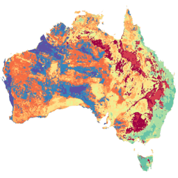
Descripción
La cuadrícula de suelo y paisaje de Australia (SLGA) es un conjunto de datos integral de atributos del suelo en toda Australia con una resolución de 3 segundos de arco (píxeles de ~90 m). Las superficies son los resultados del modelado que describen la distribución espacial de los atributos del suelo a partir de los datos existentes del suelo y las covariables ambientales. Consulta Viscarra Rossel et al. (2015) para obtener más detalles. El SLGA se puede usar en estudios de procesos de la zona vadosa, como el transporte de solutos, los flujos de agua subterránea y nutrientes más allá de la zona radicular, así como en un amplio espectro de aplicaciones ecológicas, hidrológicas y ambientales más amplias.
Cada producto contiene seis mapas digitales de atributos del suelo y sus límites superior e inferior de confianza, que representan el atributo del suelo en seis profundidades: de 0 a 5 cm, de 5 a 15 cm, de 15 a 30 cm, de 30 a 60 cm, de 60 a 100 cm y de 100 a 200 cm. Estos atributos de profundidad y suelo son coherentes con las especificaciones de GlobalSoilMap.
Esta colección tiene 12 imágenes. Diez de ellos contienen datos de los atributos principales del suelo del GSM, y los otros dos contienen atributos del GSM de profundidad del regolito y profundidad del suelo.
| Atributo | Descripción | Código | Cantidad de bandas |
|---|---|---|---|
| Densidad aparente (toda la Tierra) | Densidad aparente de todo el suelo (incluidos los fragmentos gruesos) en masa por unidad de volumen con un método equivalente al método de núcleo | BDW | 18 |
| Carbono orgánico | Fracción de masa de carbono por peso en el material del suelo de menos de 2 mm según lo determinado por combustión seca a 900 grados Celsius | SOC | 18 |
| Arcilla | Fracción de masa inferior a 2 µm del material del suelo inferior a 2 mm determinada con el método de pipeta | CLY | 18 |
| Limo | Fracción de masa de 2 a 20 µm del material del suelo de menos de 2 mm determinada con el método de pipeta | SLT | 18 |
| Arena | Fracción de masa de 20 µm a 2 mm del material del suelo de menos de 2 mm determinada con el método de pipeta | SND | 18 |
| pH (CaCl2) | pH de la extracción de cloruro de calcio 0.01 M en una proporción de 1:5 de suelo | pHc | 18 |
| Capacidad de agua disponible | Capacidad de agua disponible calculada para cada uno de los incrementos de profundidad especificados | AWC | 18 |
| Nitrógeno total | Fracción de masa del nitrógeno total en el suelo por peso | NTO | 18 |
| Fósforo total | Fracción de masa del fósforo total en el suelo por peso | PTO | 18 |
| Capacidad de intercambio catiónico efectiva | Cationes extraídos con cloruro de bario (BaCl2) más H + Al intercambiables | ECE | 18 |
| Profundidad del regolito | Profundidad hasta la roca dura. La profundidad incluye todo el regolito. | DER | 3 |
| Profundidad del suelo | Profundidad del perfil del suelo (horizontes A y B) | DES | 3 |
Bandas
Bandas
Tamaño de píxel: 92.77 metros (todas las bandas)
| Nombre | Unidades | Tamaño de los píxeles | Descripción |
|---|---|---|---|
AWC_000_005_EV |
% | 92.77 metros | Valor estimado del atributo del suelo a una profundidad de 0 a 5 cm |
AWC_000_005_05 |
% | 92.77 metros | Límite inferior del percentil 5 de confianza del atributo del suelo a una profundidad de 0 a 5 cm |
AWC_000_005_95 |
% | 92.77 metros | Límite de confianza del percentil 95 del atributo del suelo a una profundidad de 0 a 5 cm |
AWC_005_015_EV |
% | 92.77 metros | Valor estimado del atributo del suelo a una profundidad de 5 a 15 cm |
AWC_005_015_05 |
% | 92.77 metros | Límite inferior del intervalo de confianza del percentil 5 del atributo del suelo a una profundidad de 5 a 15 cm |
AWC_005_015_95 |
% | 92.77 metros | Límite de confianza del percentil 95 del atributo del suelo a una profundidad de 5 a 15 cm |
AWC_015_030_EV |
% | 92.77 metros | Valor estimado del atributo del suelo a una profundidad de 15 a 30 cm |
AWC_015_030_05 |
% | 92.77 metros | Límite de confianza del percentil 5 del atributo del suelo a una profundidad de 15 a 30 cm |
AWC_015_030_95 |
% | 92.77 metros | Límite de confianza del percentil 95 del atributo del suelo a una profundidad de 15 a 30 cm |
AWC_030_060_EV |
% | 92.77 metros | Valor estimado del atributo del suelo a una profundidad de 30 a 60 cm |
AWC_030_060_05 |
% | 92.77 metros | Límite inferior del intervalo de confianza del percentil 5 del atributo del suelo a una profundidad de 30 a 60 cm |
AWC_030_060_95 |
% | 92.77 metros | Límite de confianza del percentil 95 del atributo del suelo a una profundidad de 30 a 60 cm |
AWC_060_100_EV |
% | 92.77 metros | Valor estimado del atributo del suelo a una profundidad de 60 a 100 cm |
AWC_060_100_05 |
% | 92.77 metros | Límite de confianza del percentil 5 del atributo del suelo a una profundidad de 60 a 100 cm |
AWC_060_100_95 |
% | 92.77 metros | Límite de confianza del percentil 95 del atributo del suelo a una profundidad de 60 a 100 cm |
AWC_100_200_EV |
% | 92.77 metros | Valor estimado del atributo del suelo a una profundidad de 100 a 200 cm |
AWC_100_200_05 |
% | 92.77 metros | El límite inferior del intervalo de confianza del percentil 5 del atributo del suelo a una profundidad de 100 a 200 cm |
AWC_100_200_95 |
% | 92.77 metros | Límite de confianza del percentil 95 del atributo del suelo a una profundidad de 100 a 200 cm |
BDW_000_005_EV |
g/cm³ | 92.77 metros | Valor estimado del atributo del suelo a una profundidad de 0 a 5 cm |
BDW_000_005_05 |
g/cm³ | 92.77 metros | Límite inferior del percentil 5 de confianza del atributo del suelo a una profundidad de 0 a 5 cm |
BDW_000_005_95 |
g/cm³ | 92.77 metros | Límite de confianza del percentil 95 del atributo del suelo a una profundidad de 0 a 5 cm |
BDW_005_015_EV |
g/cm³ | 92.77 metros | Valor estimado del atributo del suelo a una profundidad de 5 a 15 cm |
BDW_005_015_05 |
g/cm³ | 92.77 metros | Límite inferior del intervalo de confianza del percentil 5 del atributo del suelo a una profundidad de 5 a 15 cm |
BDW_005_015_95 |
g/cm³ | 92.77 metros | Límite de confianza del percentil 95 del atributo del suelo a una profundidad de 5 a 15 cm |
BDW_015_030_EV |
g/cm³ | 92.77 metros | Valor estimado del atributo del suelo a una profundidad de 15 a 30 cm |
BDW_015_030_05 |
g/cm³ | 92.77 metros | Límite de confianza del percentil 5 del atributo del suelo a una profundidad de 15 a 30 cm |
BDW_015_030_95 |
g/cm³ | 92.77 metros | Límite de confianza del percentil 95 del atributo del suelo a una profundidad de 15 a 30 cm |
BDW_030_060_EV |
g/cm³ | 92.77 metros | Valor estimado del atributo del suelo a una profundidad de 30 a 60 cm |
BDW_030_060_05 |
g/cm³ | 92.77 metros | Límite inferior del intervalo de confianza del percentil 5 del atributo del suelo a una profundidad de 30 a 60 cm |
BDW_030_060_95 |
g/cm³ | 92.77 metros | Límite de confianza del percentil 95 del atributo del suelo a una profundidad de 30 a 60 cm |
BDW_060_100_EV |
g/cm³ | 92.77 metros | Valor estimado del atributo del suelo a una profundidad de 60 a 100 cm |
BDW_060_100_05 |
g/cm³ | 92.77 metros | Límite de confianza del percentil 5 del atributo del suelo a una profundidad de 60 a 100 cm |
BDW_060_100_95 |
g/cm³ | 92.77 metros | Límite de confianza del percentil 95 del atributo del suelo a una profundidad de 60 a 100 cm |
BDW_100_200_EV |
g/cm³ | 92.77 metros | Valor estimado del atributo del suelo a una profundidad de 100 a 200 cm |
BDW_100_200_05 |
g/cm³ | 92.77 metros | El límite inferior del intervalo de confianza del percentil 5 del atributo del suelo a una profundidad de 100 a 200 cm |
BDW_100_200_95 |
g/cm³ | 92.77 metros | Límite de confianza del percentil 95 del atributo del suelo a una profundidad de 100 a 200 cm |
CLY_000_005_EV |
% | 92.77 metros | Valor estimado del atributo del suelo a una profundidad de 0 a 5 cm |
CLY_000_005_05 |
% | 92.77 metros | Límite inferior del percentil 5 de confianza del atributo del suelo a una profundidad de 0 a 5 cm |
CLY_000_005_95 |
% | 92.77 metros | Límite de confianza del percentil 95 del atributo del suelo a una profundidad de 0 a 5 cm |
CLY_005_015_EV |
% | 92.77 metros | Valor estimado del atributo del suelo a una profundidad de 5 a 15 cm |
CLY_005_015_05 |
% | 92.77 metros | Límite inferior del intervalo de confianza del percentil 5 del atributo del suelo a una profundidad de 5 a 15 cm |
CLY_005_015_95 |
% | 92.77 metros | Límite de confianza del percentil 95 del atributo del suelo a una profundidad de 5 a 15 cm |
CLY_015_030_EV |
% | 92.77 metros | Valor estimado del atributo del suelo a una profundidad de 15 a 30 cm |
CLY_015_030_05 |
% | 92.77 metros | Límite de confianza del percentil 5 del atributo del suelo a una profundidad de 15 a 30 cm |
CLY_015_030_95 |
% | 92.77 metros | Límite de confianza del percentil 95 del atributo del suelo a una profundidad de 15 a 30 cm |
CLY_030_060_EV |
% | 92.77 metros | Valor estimado del atributo del suelo a una profundidad de 30 a 60 cm |
CLY_030_060_05 |
% | 92.77 metros | Límite inferior del intervalo de confianza del percentil 5 del atributo del suelo a una profundidad de 30 a 60 cm |
CLY_030_060_95 |
% | 92.77 metros | Límite de confianza del percentil 95 del atributo del suelo a una profundidad de 30 a 60 cm |
CLY_060_100_EV |
% | 92.77 metros | Valor estimado del atributo del suelo a una profundidad de 60 a 100 cm |
CLY_060_100_05 |
% | 92.77 metros | Límite de confianza del percentil 5 del atributo del suelo a una profundidad de 60 a 100 cm |
CLY_060_100_95 |
% | 92.77 metros | Límite de confianza del percentil 95 del atributo del suelo a una profundidad de 60 a 100 cm |
CLY_100_200_EV |
% | 92.77 metros | Valor estimado del atributo del suelo a una profundidad de 100 a 200 cm |
CLY_100_200_05 |
% | 92.77 metros | El límite inferior del intervalo de confianza del percentil 5 del atributo del suelo a una profundidad de 100 a 200 cm |
CLY_100_200_95 |
% | 92.77 metros | Límite de confianza del percentil 95 del atributo del suelo a una profundidad de 100 a 200 cm |
DER_000_200_EV |
m | 92.77 metros | El valor estimado de la profundidad del regolito |
DER_000_200_05 |
m | 92.77 metros | Límite de confianza del percentil 5 para la profundidad del regolito |
DER_000_200_95 |
m | 92.77 metros | Límite de confianza del percentil 95 para la profundidad del regolito |
DES_000_200_EV |
m | 92.77 metros | Valor estimado de la profundidad del suelo |
DES_000_200_05 |
m | 92.77 metros | Límite de confianza del percentil 5 para la profundidad del suelo |
DES_000_200_95 |
m | 92.77 metros | Límite de confianza del percentil 5 para la profundidad del suelo |
ECE_000_005_EV |
meq/100 g | 92.77 metros | Valor estimado del atributo del suelo a una profundidad de 0 a 5 cm |
ECE_000_005_05 |
meq/100 g | 92.77 metros | Límite inferior del percentil 5 de confianza del atributo del suelo a una profundidad de 0 a 5 cm |
ECE_000_005_95 |
meq/100 g | 92.77 metros | Límite de confianza del percentil 95 del atributo del suelo a una profundidad de 0 a 5 cm |
ECE_005_015_EV |
meq/100 g | 92.77 metros | Valor estimado del atributo del suelo a una profundidad de 5 a 15 cm |
ECE_005_015_05 |
meq/100 g | 92.77 metros | Límite inferior del intervalo de confianza del percentil 5 del atributo del suelo a una profundidad de 5 a 15 cm |
ECE_005_015_95 |
meq/100 g | 92.77 metros | Límite de confianza del percentil 95 del atributo del suelo a una profundidad de 5 a 15 cm |
ECE_015_030_EV |
meq/100 g | 92.77 metros | Valor estimado del atributo del suelo a una profundidad de 15 a 30 cm |
ECE_015_030_05 |
meq/100 g | 92.77 metros | Límite de confianza del percentil 5 del atributo del suelo a una profundidad de 15 a 30 cm |
ECE_015_030_95 |
meq/100 g | 92.77 metros | Límite de confianza del percentil 95 del atributo del suelo a una profundidad de 15 a 30 cm |
ECE_030_060_EV |
meq/100 g | 92.77 metros | Valor estimado del atributo del suelo a una profundidad de 30 a 60 cm |
ECE_030_060_05 |
meq/100 g | 92.77 metros | Límite inferior del intervalo de confianza del percentil 5 del atributo del suelo a una profundidad de 30 a 60 cm |
ECE_030_060_95 |
meq/100 g | 92.77 metros | Límite de confianza del percentil 95 del atributo del suelo a una profundidad de 30 a 60 cm |
ECE_060_100_EV |
meq/100 g | 92.77 metros | Valor estimado del atributo del suelo a una profundidad de 60 a 100 cm |
ECE_060_100_05 |
meq/100 g | 92.77 metros | Límite de confianza del percentil 5 del atributo del suelo a una profundidad de 60 a 100 cm |
ECE_060_100_95 |
meq/100 g | 92.77 metros | Límite de confianza del percentil 95 del atributo del suelo a una profundidad de 60 a 100 cm |
ECE_100_200_EV |
meq/100 g | 92.77 metros | Valor estimado del atributo del suelo a una profundidad de 100 a 200 cm |
ECE_100_200_05 |
meq/100 g | 92.77 metros | Límite inferior del intervalo de confianza del percentil 5 del atributo del suelo a una profundidad de 100 a 200 cm |
ECE_100_200_95 |
meq/100 g | 92.77 metros | Límite de confianza del percentil 95 del atributo del suelo a una profundidad de 100 a 200 cm |
NTO_000_005_EV |
% | 92.77 metros | Valor estimado del atributo del suelo a una profundidad de 0 a 5 cm |
NTO_000_005_05 |
% | 92.77 metros | Límite inferior del percentil 5 de confianza del atributo del suelo a una profundidad de 0 a 5 cm |
NTO_000_005_95 |
% | 92.77 metros | Límite de confianza del percentil 95 del atributo del suelo a una profundidad de 0 a 5 cm |
NTO_005_015_EV |
% | 92.77 metros | Valor estimado del atributo del suelo a una profundidad de 5 a 15 cm |
NTO_005_015_05 |
% | 92.77 metros | Límite inferior del intervalo de confianza del percentil 5 del atributo del suelo a una profundidad de 5 a 15 cm |
NTO_005_015_95 |
% | 92.77 metros | Límite de confianza del percentil 95 del atributo del suelo a una profundidad de 5 a 15 cm |
NTO_015_030_EV |
% | 92.77 metros | Valor estimado del atributo del suelo a una profundidad de 15 a 30 cm |
NTO_015_030_05 |
% | 92.77 metros | Límite de confianza del percentil 5 del atributo del suelo a una profundidad de 15 a 30 cm |
NTO_015_030_95 |
% | 92.77 metros | Límite de confianza del percentil 95 del atributo del suelo a una profundidad de 15 a 30 cm |
NTO_030_060_EV |
% | 92.77 metros | Valor estimado del atributo del suelo a una profundidad de 30 a 60 cm |
NTO_030_060_05 |
% | 92.77 metros | Límite inferior del intervalo de confianza del percentil 5 del atributo del suelo a una profundidad de 30 a 60 cm |
NTO_030_060_95 |
% | 92.77 metros | Límite de confianza del percentil 95 del atributo del suelo a una profundidad de 30 a 60 cm |
NTO_060_100_EV |
% | 92.77 metros | Valor estimado del atributo del suelo a una profundidad de 60 a 100 cm |
NTO_060_100_05 |
% | 92.77 metros | Límite de confianza del percentil 5 del atributo del suelo a una profundidad de 60 a 100 cm |
NTO_060_100_95 |
% | 92.77 metros | Límite de confianza del percentil 95 del atributo del suelo a una profundidad de 60 a 100 cm |
NTO_100_200_EV |
% | 92.77 metros | Valor estimado del atributo del suelo a una profundidad de 100 a 200 cm |
NTO_100_200_05 |
% | 92.77 metros | El límite inferior del intervalo de confianza del percentil 5 del atributo del suelo a una profundidad de 100 a 200 cm |
NTO_100_200_95 |
% | 92.77 metros | Límite de confianza del percentil 95 del atributo del suelo a una profundidad de 100 a 200 cm |
pHc_000_005_EV |
92.77 metros | Valor estimado del atributo del suelo a una profundidad de 0 a 5 cm |
|
pHc_000_005_05 |
92.77 metros | Límite inferior del percentil 5 de confianza del atributo del suelo a una profundidad de 0 a 5 cm |
|
pHc_000_005_95 |
92.77 metros | Límite de confianza del percentil 95 del atributo del suelo a una profundidad de 0 a 5 cm |
|
pHc_005_015_EV |
92.77 metros | Valor estimado del atributo del suelo a una profundidad de 5 a 15 cm |
|
pHc_005_015_05 |
92.77 metros | Límite inferior del intervalo de confianza del percentil 5 del atributo del suelo a una profundidad de 5 a 15 cm |
|
pHc_005_015_95 |
92.77 metros | Límite de confianza del percentil 95 del atributo del suelo a una profundidad de 5 a 15 cm |
|
pHc_015_030_EV |
92.77 metros | Valor estimado del atributo del suelo a una profundidad de 15 a 30 cm |
|
pHc_015_030_05 |
92.77 metros | Límite de confianza del percentil 5 del atributo del suelo a una profundidad de 15 a 30 cm |
|
pHc_015_030_95 |
92.77 metros | Límite de confianza del percentil 95 del atributo del suelo a una profundidad de 15 a 30 cm |
|
pHc_030_060_EV |
92.77 metros | Valor estimado del atributo del suelo a una profundidad de 30 a 60 cm |
|
pHc_030_060_05 |
92.77 metros | Límite inferior del intervalo de confianza del percentil 5 del atributo del suelo a una profundidad de 30 a 60 cm |
|
pHc_030_060_95 |
92.77 metros | Límite de confianza del percentil 95 del atributo del suelo a una profundidad de 30 a 60 cm |
|
pHc_060_100_EV |
92.77 metros | Valor estimado del atributo del suelo a una profundidad de 60 a 100 cm |
|
pHc_060_100_05 |
92.77 metros | Límite de confianza del percentil 5 del atributo del suelo a una profundidad de 60 a 100 cm |
|
pHc_060_100_95 |
92.77 metros | Límite de confianza del percentil 95 del atributo del suelo a una profundidad de 60 a 100 cm |
|
pHc_100_200_EV |
92.77 metros | Valor estimado del atributo del suelo a una profundidad de 100 a 200 cm |
|
pHc_100_200_05 |
92.77 metros | Límite inferior del intervalo de confianza del percentil 5 del atributo del suelo a una profundidad de 100 a 200 cm |
|
pHc_100_200_95 |
92.77 metros | Límite de confianza del percentil 95 del atributo del suelo a una profundidad de 100 a 200 cm |
|
PTO_000_005_EV |
% | 92.77 metros | Valor estimado del atributo del suelo a una profundidad de 0 a 5 cm |
PTO_000_005_05 |
% | 92.77 metros | Límite inferior del percentil 5 de confianza del atributo del suelo a una profundidad de 0 a 5 cm |
PTO_000_005_95 |
% | 92.77 metros | Límite de confianza del percentil 95 del atributo del suelo a una profundidad de 0 a 5 cm |
PTO_005_015_EV |
% | 92.77 metros | Valor estimado del atributo del suelo a una profundidad de 5 a 15 cm |
PTO_005_015_05 |
% | 92.77 metros | Límite inferior del intervalo de confianza del percentil 5 del atributo del suelo a una profundidad de 5 a 15 cm |
PTO_005_015_95 |
% | 92.77 metros | Límite de confianza del percentil 95 del atributo del suelo a una profundidad de 5 a 15 cm |
PTO_015_030_EV |
% | 92.77 metros | Valor estimado del atributo del suelo a una profundidad de 15 a 30 cm |
PTO_015_030_05 |
% | 92.77 metros | Límite de confianza del percentil 5 del atributo del suelo a una profundidad de 15 a 30 cm |
PTO_015_030_95 |
% | 92.77 metros | Límite de confianza del percentil 95 del atributo del suelo a una profundidad de 15 a 30 cm |
PTO_030_060_EV |
% | 92.77 metros | Valor estimado del atributo del suelo a una profundidad de 30 a 60 cm |
PTO_030_060_05 |
% | 92.77 metros | Límite inferior del intervalo de confianza del percentil 5 del atributo del suelo a una profundidad de 30 a 60 cm |
PTO_030_060_95 |
% | 92.77 metros | Límite de confianza del percentil 95 del atributo del suelo a una profundidad de 30 a 60 cm |
PTO_060_100_EV |
% | 92.77 metros | Valor estimado del atributo del suelo a una profundidad de 60 a 100 cm |
PTO_060_100_05 |
% | 92.77 metros | Límite de confianza del percentil 5 del atributo del suelo a una profundidad de 60 a 100 cm |
PTO_060_100_95 |
% | 92.77 metros | Límite de confianza del percentil 95 del atributo del suelo a una profundidad de 60 a 100 cm |
PTO_100_200_EV |
% | 92.77 metros | Valor estimado del atributo del suelo a una profundidad de 100 a 200 cm |
PTO_100_200_05 |
% | 92.77 metros | El límite inferior del intervalo de confianza del percentil 5 del atributo del suelo a una profundidad de 100 a 200 cm |
PTO_100_200_95 |
% | 92.77 metros | Límite de confianza del percentil 95 del atributo del suelo a una profundidad de 100 a 200 cm |
SLT_000_005_EV |
% | 92.77 metros | Valor estimado del atributo del suelo a una profundidad de 0 a 5 cm |
SLT_000_005_05 |
% | 92.77 metros | Límite inferior del percentil 5 de confianza del atributo del suelo a una profundidad de 0 a 5 cm |
SLT_000_005_95 |
% | 92.77 metros | Límite de confianza del percentil 95 del atributo del suelo a una profundidad de 0 a 5 cm |
SLT_005_015_EV |
% | 92.77 metros | Valor estimado del atributo del suelo a una profundidad de 5 a 15 cm |
SLT_005_015_05 |
% | 92.77 metros | Límite inferior del intervalo de confianza del percentil 5 del atributo del suelo a una profundidad de 5 a 15 cm |
SLT_005_015_95 |
% | 92.77 metros | Límite de confianza del percentil 95 del atributo del suelo a una profundidad de 5 a 15 cm |
SLT_015_030_EV |
% | 92.77 metros | Valor estimado del atributo del suelo a una profundidad de 15 a 30 cm |
SLT_015_030_05 |
% | 92.77 metros | Límite de confianza del percentil 5 del atributo del suelo a una profundidad de 15 a 30 cm |
SLT_015_030_95 |
% | 92.77 metros | Límite de confianza del percentil 95 del atributo del suelo a una profundidad de 15 a 30 cm |
SLT_030_060_EV |
% | 92.77 metros | Valor estimado del atributo del suelo a una profundidad de 30 a 60 cm |
SLT_030_060_05 |
% | 92.77 metros | Límite inferior del intervalo de confianza del percentil 5 del atributo del suelo a una profundidad de 30 a 60 cm |
SLT_030_060_95 |
% | 92.77 metros | Límite de confianza del percentil 95 del atributo del suelo a una profundidad de 30 a 60 cm |
SLT_060_100_EV |
% | 92.77 metros | Valor estimado del atributo del suelo a una profundidad de 60 a 100 cm |
SLT_060_100_05 |
% | 92.77 metros | Límite de confianza del percentil 5 del atributo del suelo a una profundidad de 60 a 100 cm |
SLT_060_100_95 |
% | 92.77 metros | Límite de confianza del percentil 95 del atributo del suelo a una profundidad de 60 a 100 cm |
SLT_100_200_EV |
% | 92.77 metros | Valor estimado del atributo del suelo a una profundidad de 100 a 200 cm |
SLT_100_200_05 |
% | 92.77 metros | El límite inferior del intervalo de confianza del percentil 5 del atributo del suelo a una profundidad de 100 a 200 cm |
SLT_100_200_95 |
% | 92.77 metros | Límite de confianza del percentil 95 del atributo del suelo a una profundidad de 100 a 200 cm |
SND_000_005_EV |
% | 92.77 metros | Valor estimado del atributo del suelo a una profundidad de 0 a 5 cm |
SND_000_005_05 |
% | 92.77 metros | Límite inferior del percentil 5 de confianza del atributo del suelo a una profundidad de 0 a 5 cm |
SND_000_005_95 |
% | 92.77 metros | Límite de confianza del percentil 95 del atributo del suelo a una profundidad de 0 a 5 cm |
SND_005_015_EV |
% | 92.77 metros | Valor estimado del atributo del suelo a una profundidad de 5 a 15 cm |
SND_005_015_05 |
% | 92.77 metros | Límite inferior del intervalo de confianza del percentil 5 del atributo del suelo a una profundidad de 5 a 15 cm |
SND_005_015_95 |
% | 92.77 metros | Límite de confianza del percentil 95 del atributo del suelo a una profundidad de 5 a 15 cm |
SND_015_030_EV |
% | 92.77 metros | Valor estimado del atributo del suelo a una profundidad de 15 a 30 cm |
SND_015_030_05 |
% | 92.77 metros | Límite de confianza del percentil 5 del atributo del suelo a una profundidad de 15 a 30 cm |
SND_015_030_95 |
% | 92.77 metros | Límite de confianza del percentil 95 del atributo del suelo a una profundidad de 15 a 30 cm |
SND_030_060_EV |
% | 92.77 metros | Valor estimado del atributo del suelo a una profundidad de 30 a 60 cm |
SND_030_060_05 |
% | 92.77 metros | Límite inferior del intervalo de confianza del percentil 5 del atributo del suelo a una profundidad de 30 a 60 cm |
SND_030_060_95 |
% | 92.77 metros | Límite de confianza del percentil 95 del atributo del suelo a una profundidad de 30 a 60 cm |
SND_060_100_EV |
% | 92.77 metros | Valor estimado del atributo del suelo a una profundidad de 60 a 100 cm |
SND_060_100_05 |
% | 92.77 metros | Límite de confianza del percentil 5 del atributo del suelo a una profundidad de 60 a 100 cm |
SND_060_100_95 |
% | 92.77 metros | Límite de confianza del percentil 95 del atributo del suelo a una profundidad de 60 a 100 cm |
SND_100_200_EV |
% | 92.77 metros | Valor estimado del atributo del suelo a una profundidad de 100 a 200 cm |
SND_100_200_05 |
% | 92.77 metros | El límite inferior del intervalo de confianza del percentil 5 del atributo del suelo a una profundidad de 100 a 200 cm |
SND_100_200_95 |
% | 92.77 metros | Límite de confianza del percentil 95 del atributo del suelo a una profundidad de 100 a 200 cm |
SOC_000_005_EV |
% | 92.77 metros | Valor estimado del atributo del suelo a una profundidad de 0 a 5 cm |
SOC_000_005_05 |
% | 92.77 metros | Límite inferior del percentil 5 de confianza del atributo del suelo a una profundidad de 0 a 5 cm |
SOC_000_005_95 |
% | 92.77 metros | Límite de confianza del percentil 95 del atributo del suelo a una profundidad de 0 a 5 cm |
SOC_005_015_EV |
% | 92.77 metros | Valor estimado del atributo del suelo a una profundidad de 5 a 15 cm |
SOC_005_015_05 |
% | 92.77 metros | Límite inferior del intervalo de confianza del percentil 5 del atributo del suelo a una profundidad de 5 a 15 cm |
SOC_005_015_95 |
% | 92.77 metros | Límite de confianza del percentil 95 del atributo del suelo a una profundidad de 5 a 15 cm |
SOC_015_030_EV |
% | 92.77 metros | Valor estimado del atributo del suelo a una profundidad de 15 a 30 cm |
SOC_015_030_05 |
% | 92.77 metros | Límite de confianza del percentil 5 del atributo del suelo a una profundidad de 15 a 30 cm |
SOC_015_030_95 |
% | 92.77 metros | Límite de confianza del percentil 95 del atributo del suelo a una profundidad de 15 a 30 cm |
SOC_030_060_EV |
% | 92.77 metros | Valor estimado del atributo del suelo a una profundidad de 30 a 60 cm |
SOC_030_060_05 |
% | 92.77 metros | Límite inferior del intervalo de confianza del percentil 5 del atributo del suelo a una profundidad de 30 a 60 cm |
SOC_030_060_95 |
% | 92.77 metros | Límite de confianza del percentil 95 del atributo del suelo a una profundidad de 30 a 60 cm |
SOC_060_100_EV |
% | 92.77 metros | Valor estimado del atributo del suelo a una profundidad de 60 a 100 cm |
SOC_060_100_05 |
% | 92.77 metros | Límite de confianza del percentil 5 del atributo del suelo a una profundidad de 60 a 100 cm |
SOC_060_100_95 |
% | 92.77 metros | Límite de confianza del percentil 95 del atributo del suelo a una profundidad de 60 a 100 cm |
SOC_100_200_EV |
% | 92.77 metros | Valor estimado del atributo del suelo a una profundidad de 100 a 200 cm |
SOC_100_200_05 |
% | 92.77 metros | El límite inferior del intervalo de confianza del percentil 5 del atributo del suelo a una profundidad de 100 a 200 cm |
SOC_100_200_95 |
% | 92.77 metros | Límite de confianza del percentil 95 del atributo del suelo a una profundidad de 100 a 200 cm |
Propiedades de imágenes
Propiedades de la imagen
| Nombre | Tipo | Descripción |
|---|---|---|
| anzlic_topic_category | STRING | Categoría de tema según el Consejo de Información Espacial de Australia y Nueva Zelanda |
| contacto | STRING | Contacto general |
| contact_gee_ingestion | STRING | Con quién comunicarse si hay problemas relacionados con la transferencia de datos a Earth Engine |
| contact_lead_researcher | STRING | Investigador principal |
| contact_project_director | STRING | Director del proyecto |
| contact_project_leader | STRING | Líder del proyecto |
| country | STRING | País que abarca este recurso |
| country_code | STRING | Código de país ISO |
| crédito | STRING | Crédito |
| tipo de datos | STRING | "Valor numérico" o "Valor categórico" |
| datatype_code | STRING | "N" o "C" |
| date_created | DOUBLE | Fecha de publicación |
| estimate_spatial_support | STRING | GSM v2.3, nivel 1 o 2, "P" o "B" |
| estimate_spatial_support_code | STRING | Estimación puntual o estimación de bloque |
| field_of_research | STRING | "Ciencias del suelo no clasificadas en otra parte" |
| gsm_type | STRING | Tipo de atributo de GlobalSoilMap |
| product_type | STRING | "Métodos de kriging y minería de datos", "Modelos compuestos". Varios modelos combinados con promedios ponderados por varianza" o "Métodos de desagregación de polígonos" |
| product_type_code | STRING | "N", "C" o "D" |
| proyecto | STRING | "National Soil Attribute Maps - Composite product", "Australia-wide 3D Soil Attribute Maps", "Western Australia Polygon Dissaggregation (DAFW)", "South Australia Polygon Dissaggregation (DEWNR)" o "Tasmania (DPIWE) Soil Attribute Mapping" |
| project_code | STRING | "NAT", "TRN", "WAT", "SAT" o "TAS" |
| provider_url | STRING | URL del proveedor |
| rights_statement | STRING | Declaración de derechos |
Condiciones de Uso
Condiciones de Uso
Todos los productos desarrollados por Soil and Landscape Grid of Australia están disponibles sin costo bajo una licencia de Creative Commons Attribution (CC BY), y los usuarios deben leer la Renuncia de responsabilidad.
Citas
Viscarra Rossel, Raphael; Chen, Charlie; Grundy, Mike; Searle, Ross; Clifford, David; Odgers, Nathan; Holmes, Karen; Griffin, Ted; Liddicoat, Craig; Kidd, Darren (2014): Soil and Landscape Grid National Soil Attribute Maps - SOIL ATTRIBUTE Release 1. v2. CSIRO. Recopilación de datos doi:10.1071/SR14366.
Viscarra Rossel, R., Chen, C., Grundy, M., Searle, R., Clifford, D., Odgers, N., Holmes, K., Griffin, T., Liddicoat, C., y Kidd, D. (2014). Soil and Landscape Grid National Soil Attribute Maps - Bulk Density - Whole Earth (3" resolution) - Release 1 [Conjunto de datos]. CSIRO.
Viscarra Rossel, R., Chen, C., Grundy, M., Searle, R., Odgers, N., Holmes, K., Griffin, T., Liddicoat, C., Kidd, D., y Clifford, D. (2014). Soil and Landscape Grid National Soil Attribute Maps - Clay (resolución de 3") - Release 1 [Conjunto de datos]. CSIRO.
Viscarra Rossel, R., Chen, C., Grundy, M., Searle, R., Clifford, D., Odgers, N., Holmes, K., Griffin, T., Liddicoat, C., y Kidd, D. (2014). Soil and Landscape Grid National Soil Attribute Maps - Effective Cation Exchange Capacity (3" resolution) - Release 1 [Conjunto de datos]. CSIRO.
Viscarra Rossel, R., Chen, C., Grundy, M., Searle, R., Clifford, D., Odgers, N., Holmes, K., Griffin, T., Liddicoat, C., y Kidd, D. (2014). Soil and Landscape Grid National Soil Attribute Maps - pH - CaCl2 (resolución de 3") - Versión 1 [Conjunto de datos]. CSIRO.
Viscarra Rossel, R., Chen, C., Grundy, M., Searle, R., Odgers, N., Holmes, K., Griffin, T., Liddicoat, C., Kidd, D., y Clifford, D. (2014). Soil and Landscape Grid National Soil Attribute Maps - Sand (resolución de 3") - Release 1 [Conjunto de datos]. CSIRO.
Viscarra Rossel, R., Chen, C., Grundy, M., Searle, R., Odgers, N., Holmes, K., Griffin, T., Liddicoat, C., Kidd, D., y Clifford, D. (2014). Soil and Landscape Grid National Soil Attribute Maps - Silt (resolución de 3") - Release 1 [Conjunto de datos]. CSIRO.
Viscarra Rossel, R., Chen, C., Grundy, M., Searle, R., Clifford, D., Odgers, N., Holmes, K., Griffin, T., Liddicoat, C., y Kidd, D. (2014). Soil and Landscape Grid National Soil Attribute Maps - Soil Depth (resolución de 3") - Versión 1 [Conjunto de datos]. CSIRO.
Viscarra Rossel, R., Chen, C., Grundy, M., Searle, R., Clifford, D., Odgers, N., Holmes, K., Griffin, T., Liddicoat, C., y Kidd, D. (2014). Soil and Landscape Grid National Soil Attribute Maps - Total Nitrogen (resolución de 3") - Versión 1 [Conjunto de datos]. CSIRO.
Viscarra Rossel, R., Chen, C., Grundy, M., Searle, R., Clifford, D., Odgers, N., Holmes, K., Griffin, T., Liddicoat, C., y Kidd, D. (2014). Soil and Landscape Grid National Soil Attribute Maps - Total Phosphorus (resolución de 3") - Versión 1 [Conjunto de datos]. CSIRO.
Viscarra Rossel, R., Chen, C., Grundy, M., Searle, R., Clifford, D., Odgers, N., Holmes, K., Griffin, T., Liddicoat, C., y Kidd, D. (2014). Soil and Landscape Grid National Soil Attribute Maps - Organic Carbon (3" resolution) - Release 1 [Conjunto de datos]. CSIRO.
Wilford, J., Searle, R., Thomas, M., y Grundy, M. (2015). Soil and Landscape Grid National Soil Attribute Maps - Depth of Regolith (3" resolution) - Release 2 [Conjunto de datos]. CSIRO.
DOI
- https://doi.org/10.4225/08/546ED604ADD8A
- https://doi.org/10.4225/08/546EE212B0048
- https://doi.org/10.4225/08/546EEE35164BF
- https://doi.org/10.4225/08/546F091C11777
- https://doi.org/10.4225/08/546F17EC6AB6E
- https://doi.org/10.4225/08/546F29646877E
- https://doi.org/10.4225/08/546F48D6A6D48
- https://doi.org/10.4225/08/546F540FE10AA
- https://doi.org/10.4225/08/546F564AE11F9
- https://doi.org/10.4225/08/546F617719CAF
- https://doi.org/10.4225/08/547523BB0801A
- https://doi.org/10.4225/08/55C9472F05295
Explora con Earth Engine
Editor de código (JavaScript)
var dataset = ee.ImageCollection('CSIRO/SLGA')
                  .filter(ee.Filter.eq('attribute_code', 'DES'));
var soilDepth = dataset.select('DES_000_200_EV');
var soilDepthVis = {
  min: 0.1,
  max: 1.84,
  palette: ['8d6738', '252525'],
};
Map.setCenter(132.495, -21.984, 5);
Map.addLayer(soilDepth, soilDepthVis, 'Soil Depth');