Page Summary
-
The Actueel Hoogtebestand Nederland (AHN) is a dataset providing detailed and precise elevation data for the whole of the Netherlands, collected using laser technology with 5 cm vertical accuracy.
-
The AHN3 dataset, covering 2014-2019, includes 0.5m Digital Surface Model (DSM) and Digital Terrain Model (DTM) variables.
-
DTM represents ground elevation, while DSM represents the elevation of the tallest surfaces.
-
AHN datasets are Open Data, free to use without restrictions under the CC-0 license.
- Dataset Availability
- 2014-01-01T00:00:00Z–2019-01-01T00:00:00Z
- Dataset Producer
- AHN
- Tags
Description
The Actueel Hoogtebestand Nederland (AHN) is a dataset with detailed and precise elevation data for the whole of the Netherlands. Elevation information was collected from helicopters and aircraft using laser technology with vertical accuracy of 5 cm.
AHN3 Dataset contains the Netherlands AHN 0.5m DSM and DTM variables. The data cover the period between 2014 and 2019.
The Digital Terrain Model (DTM) product represents the elevation of the ground, while the Digital Surface Model (DSM) product represents the elevation of the tallest surfaces at that point.
Bands
Bands
Pixel size: 0.5 meters (all bands)
| Name | Units | Pixel Size | Description |
|---|---|---|---|
dtm |
m | 0.5 meters | Elevation of the ground |
dsm |
m | 0.5 meters | Elevation of the tallest surfaces at that point |
Terms of Use
Terms of Use
The datasets of the AHN are available as Open Data. This means that the data can be used by anyone for free and without restrictions. For more information visit the Open Data page. Downloads are available under the terms of the CC-0 license.
Explore with Earth Engine
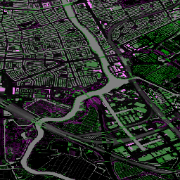
Code Editor (JavaScript)
var dataset = ee.ImageCollection('AHN/AHN3');
var elevation = dataset.select('dsm');
var elevationVis = {
  min: -5.0,
  max: 30.0,
};
Map.setCenter(5.76583, 51.855276, 16);
Map.addLayer(elevation, elevationVis, 'AHN3 dsm');