Datasets tagged political in Earth Engine
Sử dụng bộ sưu tập để sắp xếp ngăn nắp các trang
Lưu và phân loại nội dung dựa trên lựa chọn ưu tiên của bạn.
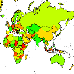
Văn phòng Nhà địa lý học của Hoa Kỳ cung cấp tập dữ liệu Ranh giới quốc tế quy mô lớn (LSIB). Lớp này được lấy từ 2 tập dữ liệu khác: một tệp vectơ đường LSIB và Đường bờ biển dạng vectơ trên thế giới (WVS) của Cơ quan Tình báo Địa không gian Quốc gia (NGA). Ranh giới bên trong phản ánh … của chính phủ Hoa Kỳ
Văn phòng Nhà địa lý học của Hoa Kỳ cung cấp tập dữ liệu Ranh giới quốc tế quy mô lớn (LSIB). Phiên bản chi tiết (2013) được lấy từ 2 tập dữ liệu khác: một tệp vectơ đường LSIB và Đường bờ biển vectơ thế giới (WVS) của Cơ quan Tình báo Địa không gian Quốc gia (NGA). Ranh giới bên trong …
[[["Dễ hiểu","easyToUnderstand","thumb-up"],["Giúp tôi giải quyết được vấn đề","solvedMyProblem","thumb-up"],["Khác","otherUp","thumb-up"]],[["Thiếu thông tin tôi cần","missingTheInformationINeed","thumb-down"],["Quá phức tạp/quá nhiều bước","tooComplicatedTooManySteps","thumb-down"],["Đã lỗi thời","outOfDate","thumb-down"],["Vấn đề về bản dịch","translationIssue","thumb-down"],["Vấn đề về mẫu/mã","samplesCodeIssue","thumb-down"],["Khác","otherDown","thumb-down"]],[],[],["The US Office of the Geographer provides the Large Scale International Boundary (LSIB) dataset. The dataset comes in two versions: detailed and simplified, both derived from an LSIB line vector file and the National Geospatial-Intelligence Agency's (NGA) World Vector Shorelines (WVS). Both versions contain interior boundaries. The dataset includes political borders and information about countries.\n"]]