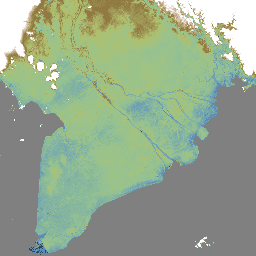
MERIT DEM, un DEM globale ad alta precisione con una risoluzione di 3 secondi d'arco (~90 m all'equatore) prodotto eliminando i principali componenti di errore dai DEM esistenti (NASA SRTM3 DEM, JAXA AW3D DEM, Viewfinder Panoramas DEM). MERIT DEM separa la distorsione assoluta, il rumore a strisce, il rumore speckle e…
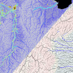
MERIT Hydro è una nuova mappa globale della direzione del flusso con una risoluzione di 3 secondi d'arco (~90 m all'equatore) derivata dalla versione 1.0.3 dei dati di elevazione MERIT DEM e dei set di dati sui corpi idrici (G1WBM, GSWO e OpenStreetMap). MERIT Hydro contiene l'output di un nuovo …
[[["Facile da capire","easyToUnderstand","thumb-up"],["Il problema è stato risolto","solvedMyProblem","thumb-up"],["Altra","otherUp","thumb-up"]],[["Mancano le informazioni di cui ho bisogno","missingTheInformationINeed","thumb-down"],["Troppo complicato/troppi passaggi","tooComplicatedTooManySteps","thumb-down"],["Obsoleti","outOfDate","thumb-down"],["Problema di traduzione","translationIssue","thumb-down"],["Problema relativo a esempi/codice","samplesCodeIssue","thumb-down"],["Altra","otherDown","thumb-down"]],[],[],["MERIT DEM is a high-accuracy global Digital Elevation Model (DEM) with a 3 arc-second resolution. It was created by removing errors from existing DEMs. MERIT Hydro, derived from MERIT DEM, is a global flow direction map, also at 3 arc-second resolution, that uses water body datasets. Supplementary visualization layers for MERIT Hydro are also available. The main actions include the creation of these datasets and the enhancement of resolution and correction of errors.\n"]]