-
MERIT Hydro: Global Hydrography Datasets
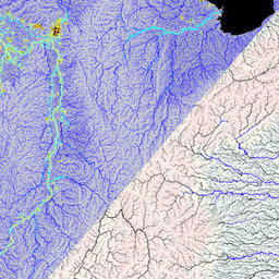
MERIT Hydro is a new global flow direction map at 3 arc-second resolution (~90 m at the equator) derived from the version 1.0.3 of the MERIT DEM elevation data and water body datasets (G1WBM, GSWO and OpenStreetMap). MERIT Hydro contains the output of a new … dem elevation flow-direction hand hydrography hydrosheds -
MERIT Hydro: Supplementary Visualization Layers

Supplementary visualization layers for MERIT Hydro dem elevation flow-direction hand hydrography hydrosheds
[{
"type": "thumb-down",
"id": "missingTheInformationINeed",
"label":"Missing the information I need"
},{
"type": "thumb-down",
"id": "tooComplicatedTooManySteps",
"label":"Too complicated / too many steps"
},{
"type": "thumb-down",
"id": "outOfDate",
"label":"Out of date"
},{
"type": "thumb-down",
"id": "samplesCodeIssue",
"label":"Samples / code issue"
},{
"type": "thumb-down",
"id": "otherDown",
"label":"Other"
}]
[{
"type": "thumb-up",
"id": "easyToUnderstand",
"label":"Easy to understand"
},{
"type": "thumb-up",
"id": "solvedMyProblem",
"label":"Solved my problem"
},{
"type": "thumb-up",
"id": "otherUp",
"label":"Other"
}]