Datasets tagged flow-direction in Earth Engine
Sử dụng bộ sưu tập để sắp xếp ngăn nắp các trang
Lưu và phân loại nội dung dựa trên lựa chọn ưu tiên của bạn.
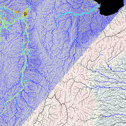
MERIT Hydro là một bản đồ hướng dòng chảy toàn cầu mới có độ phân giải 3 giây cung (~90 m ở đường xích đạo) được lấy từ phiên bản 1.0.3 của dữ liệu độ cao DEM MERIT và các tập dữ liệu về vùng nước (G1WBM, GSWO và OpenStreetMap). MERIT Hydro chứa đầu ra của một …
[[["Dễ hiểu","easyToUnderstand","thumb-up"],["Giúp tôi giải quyết được vấn đề","solvedMyProblem","thumb-up"],["Khác","otherUp","thumb-up"]],[["Thiếu thông tin tôi cần","missingTheInformationINeed","thumb-down"],["Quá phức tạp/quá nhiều bước","tooComplicatedTooManySteps","thumb-down"],["Đã lỗi thời","outOfDate","thumb-down"],["Vấn đề về bản dịch","translationIssue","thumb-down"],["Vấn đề về mẫu/mã","samplesCodeIssue","thumb-down"],["Khác","otherDown","thumb-down"]],[],[],["MERIT Hydro offers a global flow direction map with a 3 arc-second resolution, derived from MERIT DEM elevation data and water body datasets (G1WBM, GSWO, OpenStreetMap). It utilizes elevation, flow-direction, and hydrography data. It offers supplementary visualization layers that share the same data origins and tag categories, offering additional tools for understanding the hydrography data. The dataset focuses on mapping water flow direction globally.\n"]]