-
US EPA Ecoregions (Level III)
The U.S. Environmental Protection Agency (USEPA) provides the Ecoregions dataset to serve as a spatial framework for the research, assessment, management, and monitoring of ecosystems and ecosystem components. Ecoregions denote areas of general similarity in ecosystems and in the type, quality, and quantity of environmental … ecoregions epa -
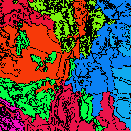
US EPA Ecoregions (Level IV)

The U.S. Environmental Protection Agency (USEPA) provides the Ecoregions dataset to serve as a spatial framework for the research, assessment, management, and monitoring of ecosystems and ecosystem components. Ecoregions denote areas of general similarity in ecosystems and in the type, quality, and quantity of environmental … ecoregions epa -
RESOLVE Ecoregions 2017
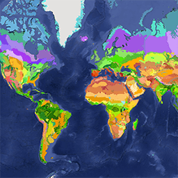
The RESOLVE Ecoregions dataset, updated in 2017, offers a depiction of the 846 terrestrial ecoregions that represent our living planet. View the stylized map at https://ecoregions2017.appspot.com/ or in Earth Engine. Ecoregions, in the simplest definition, are ecosystems of regional extent. Specifically, ecoregions represent distinct assemblages … biodiversity conservation ecoregions global
[{
"type": "thumb-down",
"id": "missingTheInformationINeed",
"label":"Missing the information I need"
},{
"type": "thumb-down",
"id": "tooComplicatedTooManySteps",
"label":"Too complicated / too many steps"
},{
"type": "thumb-down",
"id": "outOfDate",
"label":"Out of date"
},{
"type": "thumb-down",
"id": "samplesCodeIssue",
"label":"Samples / code issue"
},{
"type": "thumb-down",
"id": "otherDown",
"label":"Other"
}]
[{
"type": "thumb-up",
"id": "easyToUnderstand",
"label":"Easy to understand"
},{
"type": "thumb-up",
"id": "solvedMyProblem",
"label":"Solved my problem"
},{
"type": "thumb-up",
"id": "otherUp",
"label":"Other"
}]