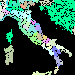
이 버전의 GAUL 데이터 세트는 500m로 단순화되었습니다. Global Administrative Unit Layers (GAUL)는 전 세계 모든 국가의 행정 단위에 관한 최적의 정보를 수집하고 배포하여 행정 단위를 나타내는 공간 데이터 세트의 표준화에 기여합니다. …
[[["이해하기 쉬움","easyToUnderstand","thumb-up"],["문제가 해결됨","solvedMyProblem","thumb-up"],["기타","otherUp","thumb-up"]],[["필요한 정보가 없음","missingTheInformationINeed","thumb-down"],["너무 복잡함/단계 수가 너무 많음","tooComplicatedTooManySteps","thumb-down"],["오래됨","outOfDate","thumb-down"],["번역 문제","translationIssue","thumb-down"],["샘플/코드 문제","samplesCodeIssue","thumb-down"],["기타","otherDown","thumb-down"]],[],[],["The Global Administrative Unit Layers (GAUL) dataset compiles and disseminates information on administrative units for all countries, aiding in the standardization of spatial datasets representing these units. Two versions are available: GAUL 2015 (second-level units) and a simplified 500m version. Both provide global layers and are related to administrative borders, counties, and districts. These datasets are made available by the FAO.\n"]]